
Dangerous double rain systems zero in on Australia’s north and east
A double whammy of treacherous rain systems are smashing much of Australia bringing dangerous downpours and a possible East Coast Low.

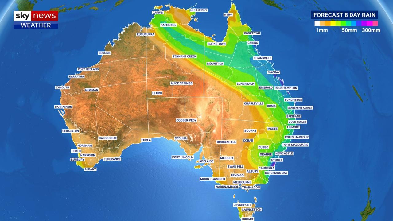
Two massive rain events have begun smashing large parts of Australia – with one potentially delivering a season’s worth of rain in just five days.
Sydney will be one of the worst affected areas over the coming days as the NSW coast between the Central Coast and the Illawarra is forecast to cop 200-300mm of rain.
Forecasters have warned the systems, including a treacherous East Coast Low zeroing in on Sydney as well as torrential rain across much of Queensland, are likely to be “intense”.
Sky News Weather senior meteorologist Tom Saunders said Katherine could record 25mm of rain as the event passes through. That’s compared to the usual 1mm the Northern Territory town receives in July.
“That’s more than 10 times the average rainfall.”
Mr Saunders said an upper level trough was the cause of the weather drama pushing up from southern Australia.
“That trough will interact with tropical moisture to produce unseasonable rain (breaking) even July records”.
Stream more weather news live & on demand with Flash. 25+ news channels in 1 place. New to Flash? Try 1 month free. Offer ends 31 October, 2022 >
Intense drenching for Queensland
The first system, crossing Australia’s north, is already in full swing.
Darwin copped 8mm of rain on Thursday while Katherine saw more than 10mm.
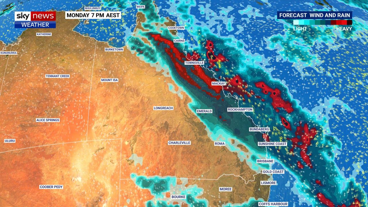
Clearing by Saturday the system is then likely to move into Queensland.
“The falls should intensify on Sunday with heavy falls likely on Monday and Tuesday through northern and eastern Queensland,” said Mr Saunders.
Between Friday and Tuesday, Rockhampton is looking at between 100-175mm of rain. Mackay could push 200mm.
“Mackay, Rockhampton – they only average about 35mm in the entire month of July. So you’re talking about a season’s worth of rain falling in one week.”
Cairns could see up to 30mm on Friday, a respite for the weekend, then between another 10 and 50mm on Monday and Tuesday with highs of 27C.
Brisbane will be soggy too. Friday could see 10-20mm come down and then 15-25mm on Saturday. A shower or two on Sunday will lead up to another 10mm on Monday and 35mm possible for Tuesday.
The Queensland capital should see highs of between 17-21C and minimums in the low teens.
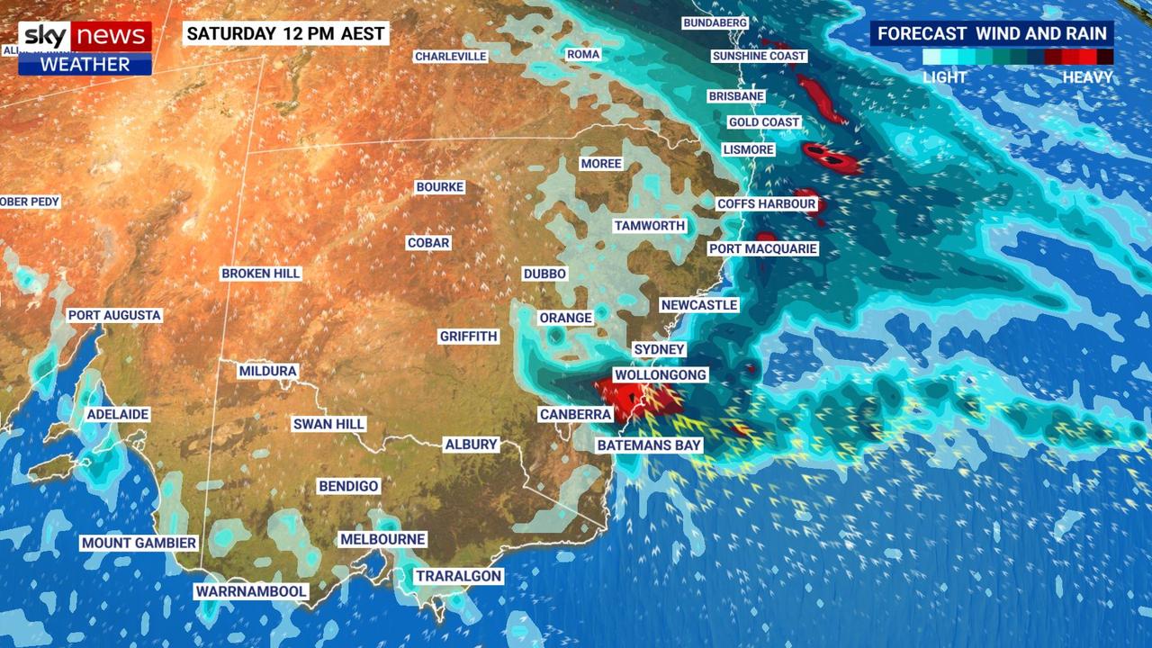
Dangerous East Coast Low brewing for NSW
Further down the coast and an East Coast Low is possible on the weekend.
These systems have many of the characteristics of cyclones but aren’t classified as such as they are in subtropical waters. That doesn’t mean they can’t pack a punch, however.
“East Coast Lows can produce torrential rain and flooding, flash flooding and river flooding, damaging winds, power outages and coastal erosion,” said Mr Saunders.
Right now it’s looking like southern Sydney and the Illawarra could see as much as 200mm of rain with 100mm for the north coast. Isolated patches of 300mm are a possibility.
The Bureau of Meteorology has the rain cranking up over Sydney from Friday when a relatively modest 15mm could fall. Then on Saturday, the forecast is for 20-40mm and 45-80mm on Sunday.
Heavy falls over Sydney continue early next week. Temperatures in the Harbour City should be around 17C with lows of 11-13C.
In northern NSW, Kempsey could see 20mm or more of rain every day from Saturday to Tuesday. Ballina is forecast to get 30mm on Saturday.
Canberra might escape the worst of the weather. But it won’t escape the rain entirely. A few showers on Friday will be followed by up to 25mm across the weekend as a whole.
It will also be getting chillier with maximums of 12C sinking to 1C on Friday morning.
Sun peeking through elsewhere
The rain will barely trouble Melbourne. It may just see a sprinkle or two on Friday and Saturday and otherwise it will be cloudy with some sun peeking through.
The mercury will peak in the mid-teens with 6C lows across the coming days and into the weekend.

A passing shower could brush through Hobart on Thursday but that’s about it for the coming days. Partly cloudy conditions are due across the weekend with highs of 11-14C and dawn minimums of 3C.
A dry weekend of mid-teen temperatures in Adelaide and nights getting down to around 7C. Sunday could see some sun.
Blissful winter blue skies are in store for Perth towards and across the weekend with balmy highs of 20C but colder mornings of 7C. Rain will return by around Tuesday.

200 species dead in ‘unprecedented’ disaster
Scientists have offered a grim outlook for Aussies hoping for an immediate solution to an ‘unprecedented’ disaster leaving the water at Aussie beaches toxic.

Australia told to brace for a soaking
Parts of Australia that have already experienced a wet weekend should expect more downpours in the week ahead.

‘Big’: Wild weather warning to Aussies
Aussies in several states have been warned to brace for a weekend of wild weather, with the risk of floods and damaging winds.