
Sydney’s coldest day for 37 years as major winter storm grips
The mercury in Sydney sank even lower then expected delivering a day that hasn’t been this chilly` for almost four decades.

It’s official – Sydney shivered through its coldest day for almost four decades today while some its suburbs were even chillier.
Sydney had a projected high of just 11C but it couldn’t even reach that instead topping out at a mere 10.3C.
The last time it was that cold was way back in 1984, 37 years ago.
Bankstown’s high of 9.6C made it the coldest day since 1983. Penrith in Sydney’s west scraped to 8.3C which is its coldest day since records began, about 25 years for that suburb.
Scone in the Hunter Valley reached 8.2C, its coldest day in more than three decades. Nearby Cessnock saw its chilliest day since records began there almost 50 years ago.
Narrabri, in the state’s north, got to 7.4C. The last day it was that cold was in 1962.
The culprit was a cold pool of Antarctic that has been barrelling across eastern Australia.
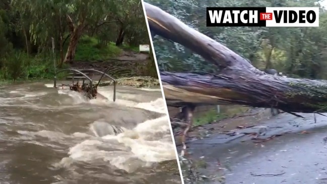
Snow blanketed many regional towns with more to come. While in Victoria, wild storms wreaked havoc with intense rain and wind bringing down trees and powerlines.
“A major winter storm outbreak continues to impact multiple states,” Sky News Weather meteorologist Alison Osborne said on Thursday.
For rolling coverage of Australia’s weather events, tune into Sky News Weather on Foxtel Channel 601

“Rare, remarkable” snowfall due
“New England (in the state’s north east) is set to see some very rare and very remarkable snowfall later today,” Ms Osborne added earlier on Thursday,
Towns including Orange, Oberon, Leura and Guyra have seen snow. Armidale and Inverell could well see some more snow later on Thursday.
Bureau of Meteorology meteorologist Gabrielle Woodhouse told news.com.au as much as half a metre of snow had descended in the last 24 hours on the Perisher and Thredbo ski resorts.
“We don’t often see really widespread snowfall across the NSW ranges all the way up to the Queensland border. And likewise, we don’t see snow falling down to such low levels so it is quite significant,” she said on Thursday afternoon.
The snow should become more contained to the ski areas on Friday and the mercury will go up a touch.
Victoria, however, could still some more rainfall before the low pressure system is done with the state.
Around 200mm of rain fell in some areas of Gippsland, in Victoria, overnight.
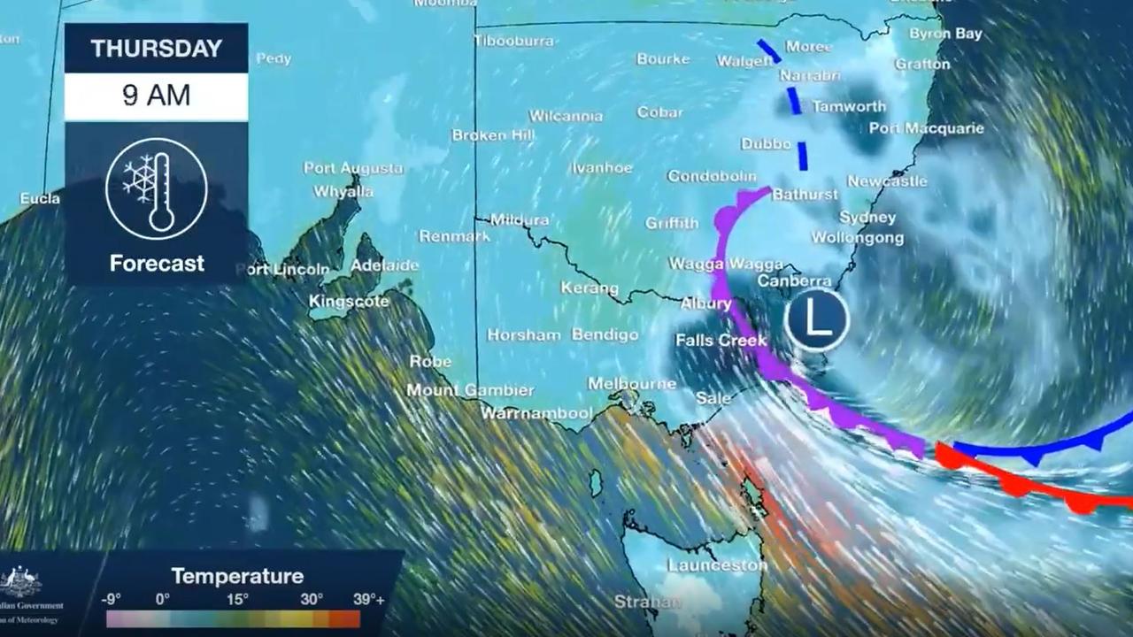
Warnings for Victoria
There are now multiple flood warnings on rivers in Victoria including the Latrobe, Maribyrnong, Goulburn, and Yarra.
Melbourne will top out at just 16C on Thursday and 15C on Friday. Rainfall of up to 25mm can be expected up until Saturday. Wet at Traralgon with 35mm from Thursday to Saturday.
RELATED: ‘Major winter storm’ set to hit Australia’s south and east

New South Wales and the ACT
As well as the chill it’s also likely to be wet in Sydney on Thursday with up to 15mm of rain with more showers on Friday.
The mercury is forecast to reach 17C on Thursday, and 19C the day after with lows of 7C.
For other areas of NSW snow and ice may lead to dangerous driving conditions.
Inverell, in northern NSW, could top out at just 6C on Thursday. Tamworth may peak at 7C – it hasn’t been that cold since 1998. Armidale could see up to 20cms of snow into a 5C Thursday.
Further south, more snow is likely for Orange, Oberon and the Blue Mountains.
On the ski resorts it’s going to be a bumper start to the snow season with up to 60cms across the Alps. Some of that snow could come in blizzards.
Rain for Canberra with showers until Friday. A high of 10C on Thursday and between 11-13C heading into the weekend. Lows nearing zero.
RELATED: Australia’s winter weather outlook: Warmer but wetter season ahead

South Australia and Tasmania
Dry in Adelaide with maximums of 17C for the rest of the week with overnight minimums of 10C.
Hobart will drop to a maximum of just 13C on Thursday before heading to the mid-teens for the weekend. Lows of 11C. Expect heavy showers of between 5-20mm most days until Saturday. A number of flood warnings are in place for eastern Tasmania
Even tropical areas could feel the chill
Brisbane will get warmer with a high of 19C today reaching 22C by Sunday but with morning lows of 8C. Generally dry in Queensland’s capital.
It will be colder further north though with Rockhampton’s minimum sinking to just 3C on Friday morning.
Up in the Top End it’s hardly going to be cold but the system farther south could have an effect bringing overnights lows into the high teens for Darwin.
A different weather system is affecting Western Australia. Thursday will see heavy falls of up to 15mm with some of the rain also heading to the south west corner of the state.
Maximums of 20C in Perth for much of the week and into the weekend.

Reason housing crisis could get worse
Australians are already facing a shortfall of more than 640,000 affordable homes. There’s one reason that might get even worse.

Severe frost alert for Aussie farmers
Farmers are being urged to keep their livestock warm as a freezing start to winter puts animals at risk.

Aussie-first hydrogen servo opens
Australia’s first publicly accessible hydrogen service station has opened, in a huge move towards decarbonising commercial vehicles.