
‘Major winter storm’ set to hit Australia’s south and east
A “major winter storm” is gearing up to bring one of the fiercest polar blasts Australia has seen in years which could even spread to tropical areas.

This week’s polar blast is shaping up to be a “major winter storm” with up to 200mm of rain, destructive winds and cooler temperatures even in tropical parts of the country.
But it’s the snow that could really be remarkable with predictions it will be the “heaviest in years,” a forecaster has said.
The Bureau of Meteorology has said “20 million Australians are set to shiver”.
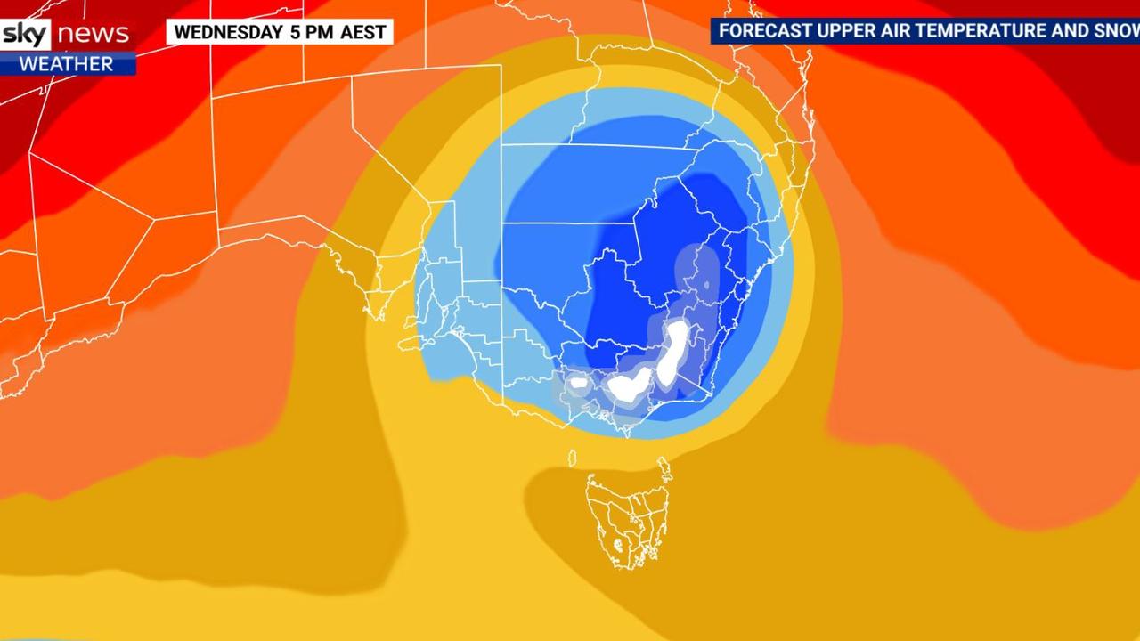
A hefty chunk of polar air has surged up from the Southern Ocean and is currently working its way across Australia’s east. A complex low is then expected to develop on Tuesday in the Tasman Sea intensifying on Wednesday and Thursday.
“This low pressure system will deepen near the far south coast of NSW while driving wild weather particularly to eastern Victoria where we’re likely to see flooding due to rainfall in the order of 100 or 200 millimetres,” Sky News Weather meteorologist Rob Sharpe said.
The low is likely to form into a huge spiral which could curve around NSW and Victoria delivering waves of rain.
Perth is away from the polar palaver but it will be hit by a weather system all of its own also bringing rain and chillier mornings.
Climate scientists have said there has been an increase in short, sharp rainfall events during winter despite lower rainfall overall in the country’s south east during April to October.
For rolling coverage of Australia’s weather events, tune into Sky News Weather on Foxtel Channel 601
Not your typical polar blast, forecasters warn
“What separates this system from typical cold outbreaks is not the temperature but the amount of moisture,” said Mr Sharpe.
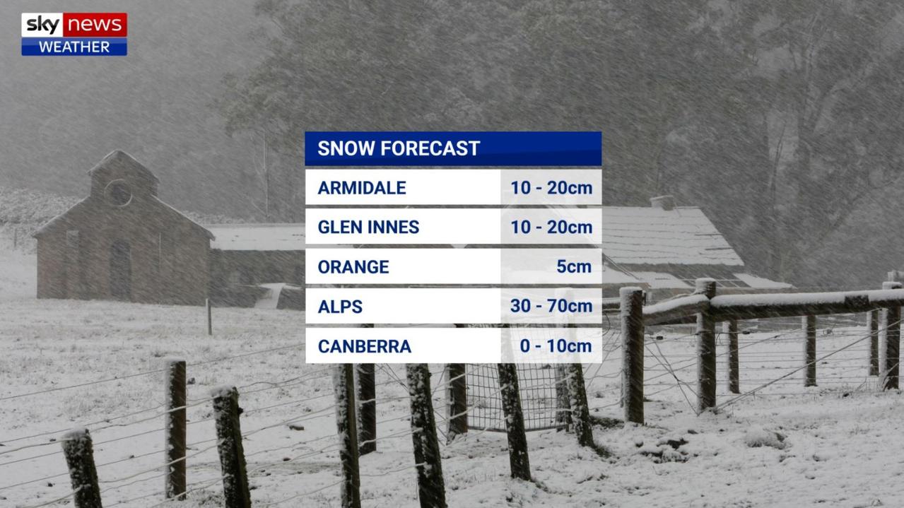
“Dustings of snow are quite common for our higher towns but anything above 5cm is rare. The heaviest snow in years is likely to fall along parts of the NSW Ranges through Wednesday and Thursday.”
Up to 20cm could fall in the Northern Tablelands, with Armidale in the firing line on Wednesday; the same day Orange, Oberon, Katoomba and Canberra could see the white stuff with healthy dumps on the ski fields
“We are expecting 30-70cm widespread for the resorts as well as some rain – particularly on the lower slopes,” said Mr Sharpe.
But southern Queensland may miss out on the snow.
“It will be cold enough, but there’s not much moisture moving through at the right time.”
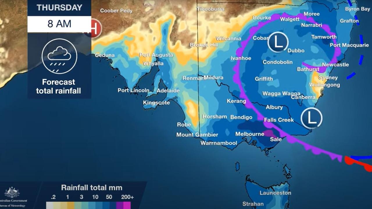
Hail, storms, wind and rain are possible from Queensland down to central NSW and the ACT through the week but it’s Victoria bearing the brunt.
The possibility of an East Coast Low remains. The Bureau of Meteorology defines an East Coast Low as an intense low pressure system which occurs a few times of year off the eastern coast of Australia.
So strong, they can produce many of the effects of cyclones but in subtropical waters.
RELATED: Australia’s winter weather outlook: Warmer but wetter season ahead

When capitals will be hit
A wet day in Adelaide but the showers should clear on Wednesday leaving cloudy skies. Temperatures will struggle to get to 13C today and 14C on Wednesday with overnight lows of 8-9C.
A severe weather warning is in place on Tuesday for Port Lincoln, Port Augusta and Whyalla for damaging gusts of up to 100km/h.
Hobart will drop to a maximum of just 11C on Wednesday and a minimum of 9C. It’s not getting much warmer only creeping up to 15C on the weekend. Some heavy falls on Wednesday and showers continuing into the weekend.
A cold and wet week in Melbourne topping out at just 13C on Tuesday and Wednesday and only reaching 16C by Friday. The coldest minimum will be 7C on Wednesday morning.
Rainfall of 6-15mm of Tuesday, up to 25mm on Wednesday and then another 10mm possible on Thursday.
Far wetter in Mallacoota though with 35-50mm on Wednesday and 40-60mm on Thursday and another 20mm on Friday.
An initial flood watch in place for multiple rivers in the Gippsland region. Flooding could be exacerbated by already swollen rivers.
Up in the Alps and it is a bumper start to the ski season with 90-130mm of snow forecast for Mt Buller and Mt Hotham from Wednesday to Friday
Across the border and Wednesday is looking particularly wet in the south east. Merimbula could see 40-60mm on Wednesday, the same again on Thursday and another 30mm is possible on Friday.
After a mild beginning to the week with highs of 20C on Tuesday, midweek in Sydney will be cold and damp.
The mercury is forecast to top out at 16C on Wednesday and 14C on Thursday with a lows of 7C.
Rain will settle in on from Wednesday with up to 10mm and then a possible 20mm on Thursday, 15mm on Friday with the rain clearing by the weekend.
Heavy rain for Canberra too with between 35 and 60mm across Wednesday and Thursday. A high of just 9C in the capital on Wednesday with Thursday dropping to -1C
â„ï¸This week, plunging temperatures will see #snow fall across parts of southern & eastern Australia, from the #BlueMountains right up to #NSW's Northern Tablelands—and possibly further north into southern #Qld. View our snow forecast maps here: https://t.co/ByG5YyVjFHpic.twitter.com/Jxl5HVMi64
— Bureau of Meteorology, Australia (@BOM_au) June 7, 2021
Even tropical areas could feel the chill
Brisbane will start the week in the mid-twenties but 18C will be the top by midweek with chilly mornings of 8C to end the week. Wednesday could see around 8mm of rain falling.
“Tropical Queensland will feel the cool change sweep through late on Wednesday,” said Mr Sharpe.
“By Thursday morning it will be much colder, particularly south from Townsville. Some areas will see nights more than 10 degrees colder than what will occur on Monday and Tuesday nights.”
Rockhampton’s minimum will sink from 16C early on Wednesday to 4C on Friday morning.
Colder in Darwin, wet in Perth
Up in the Top End it’s hardly going to be cold but the system farther south could have an effect bringing maximum temperatures down towards the end of the week to a mere 30C. Overnights lows could drop into the high teens. That’s duvet weather for Darwin.
“Western Australia has different weather system that from Wednesday into Thursday will see heavy falls in parts of the northwest and in the southwest corner we’ll see a decent amount of rainfall,” said Mr Sharpe.
Maximums of 18C in Perth for much of the week increasing to 22C on Thursday when a storm is possible. Showers sweeping through on Wednesday to Friday with between 20-40mm falling over the three days.
Water vapour satellite 🛰ï¸shows that while eastern #Australia's #weather is coming up from the south, #WA's weather is coming down from the north. As the east shivers, an unseasonal tropical low will bring #rain and wind to WA's west coast from tomorrow ðŸŒ§ï¸ pic.twitter.com/UtLMsEsVzT
— Bureau of Meteorology, Australia (@BOM_au) June 7, 2021
Short, sharp rainfall events increasing
Climate scientists have said the number of one and two day winter heavy rainfall events, which could occur this week, are on the increase.
Analysis from the Australian National University found short, sharp bursts had become more frequent and intensified while longer rain spells had decreased.
“This intensification of flash flooding has important implications for water and land management and emergency services”, said Associate Professor David Holmes from the Monash University Climate Change Communication Research Hub.
“While there will clearly be some large regional variations this finding gives a prime example of why limiting increases in global temperatures to 1.5C rather than 2C is so important.”

Reason housing crisis could get worse
Australians are already facing a shortfall of more than 640,000 affordable homes. There’s one reason that might get even worse.

Severe frost alert for Aussie farmers
Farmers are being urged to keep their livestock warm as a freezing start to winter puts animals at risk.

Aussie-first hydrogen servo opens
Australia’s first publicly accessible hydrogen service station has opened, in a huge move towards decarbonising commercial vehicles.