
Polar air set to blast south eastern Australia while desert winds scorch east coast
A blast of Antarctic air will bring back winter to some capitals, including Adelaide – but elsewhere the same system will bring scorching temperatures nearing 40C.

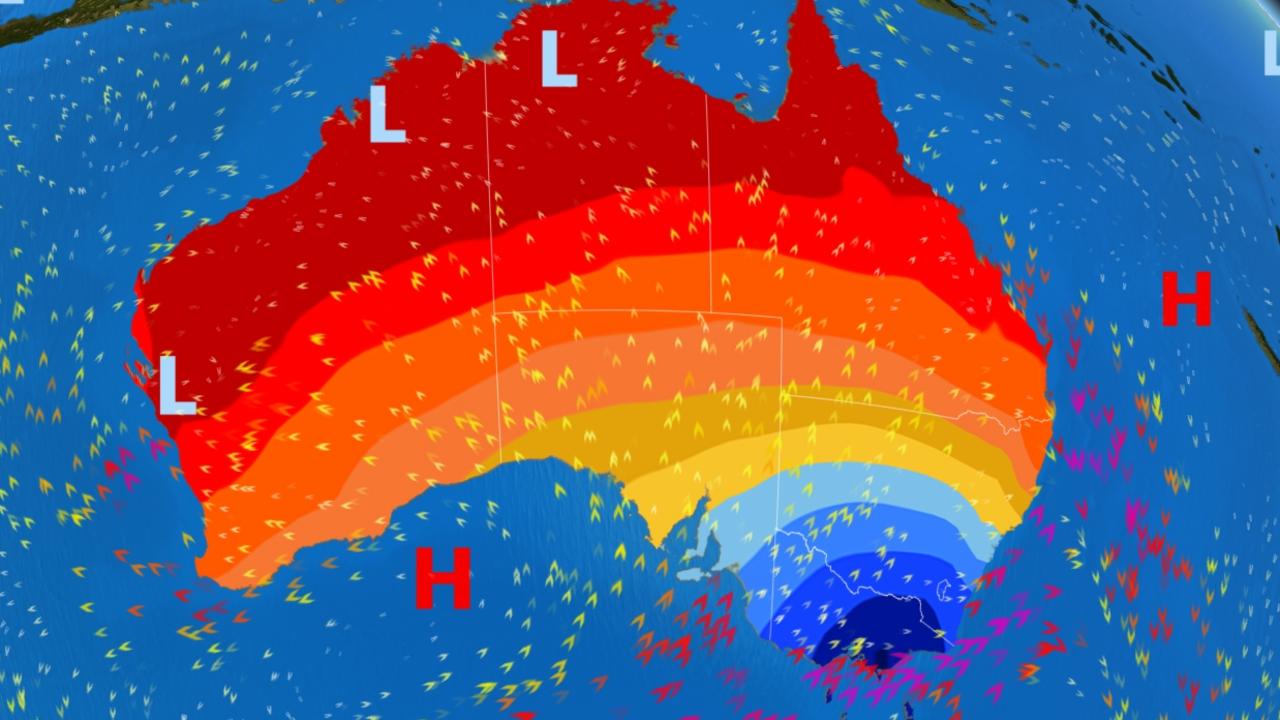
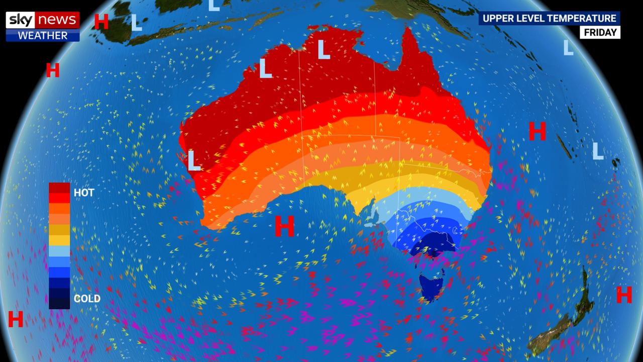
Spring is set to take a break as Antarctic air blasts its way across the continent in the coming days.
Temperatures up to 10 degrees below average will sweep across the south east, with heavy rain, gale force winds, hail and snow on high ground.
But head north and the cold front will actually have the opposite affect bringing hot desert air towards the coast and hiking up the fire danger levels.
On Friday, Melbourne will be rugging up to battle through a high of just 14C but in Brisbane they will be taking the layers off as the mercury reaches 37C.
“This week a wintry weather pattern is developing across southeastern Australia,” said Sky News Weather channel meteorologist Tom Saunders.
“We have a series of cold fronts moving through and that will bring polar air to the south east that will peak on Friday and Saturday.
“Temperatures will drop below average. They’re already 5 degrees below average in south east Australia and it will be even colder on Friday, as much as 10 degrees below average.”
ADELAIDE, MELBOURNE, HOBART AND CANBERRA
The rain will come first leading to a showery Thursday in Adelaide with the mercury getting to 19C.
There will be less rain in South Australia on Friday but also slightly cooler temperatures with a maximum of 18C and hovering around the 20C mark all weekend. Minimums of just 12C and as low as 9C on Saturday morning.
However, by Monday it will be back to more summery weather with a top of 31C forecast and clear skies, followed by 31C on Tuesday.
Quite the change from the hailstorm that devastated farms in the Riverland earlier this week.
For Melbourne, today’s 23C high will sink to 18C on a wet Thursday and then 14C on Friday. The weekend will only be a touch warmer. Cold lows of around 11C and just 8C on Saturday morning.
The average for November is for daytime highs of 22C. Ballarat will be even cooler with a high of just 11C on Friday and a wintry low of 5C.
The city can expect to see around 15mm of rain but on the coast and in eastern parts of the state that could get up to 25mm.
The Bureau of Meteorology issued a severe weather warning on Wednesday for damaging winds across the state's southern coast and into Gippsland.
Just as cold in Tasmania, with Hobart also peaking at 14C on Friday but with an even chiller low of 5C on Saturday morning. Expect maximums in the mid-teens from Thursday onwards with scattered showers.
The conditions will be cold enough for snow to fall on higher ground in Tasmania with a low of -3C on Saturday at the peak of Mt Wellington. On the mainland, the Alps could also see some flurries. Today will be windy in Tassie’s north.
Canberrans could be forgiven for thinking they’ve travelled back to winter on Saturday when the early morning low will be just 1C. Today’s 24C maximum will drop to 17C by the weekend. A possible shower on Friday.
Things are warmer in Sydney. On Thursday, temperatures could breach the 30C mark ahead of the cold front. But the weekend will see the maximums drop briefly below the November average with a Saturday high of just 21C. By Sunday, however, things will return to normal with a peak of 26C.
The Bureau warned of damaging winds across much of the Great Diving Range on Wednesday.
SEVERE WEATHER WARNING for DAMAGING WINDS issued for East Gippsland and parts of Central, South West, North East and West and South Gippsland Forecast Districts.
— VicEmergency (@vicemergency) November 6, 2019
More info https://t.co/do7sPEvQWh pic.twitter.com/U5G4scnVvl
The Fire Danger Rating is set to be SEVERE in some parts of the state over the coming days 🔥
— Qld Fire & Emergency (@QldFES) November 5, 2019
Our crews are ready to respond should a bushfire begin, however you can be on the lookout too!
If you see a fire, or your property is under threat, call Triple Zero (000) immediately. pic.twitter.com/CtTYIZ3oTI
SYDNEY, BRISBANE, DARWIN AND PERTH
Mr Saunders said the cold front would have a very different effect heading north from Sydney.
“A wintry weather pattern in late spring often leads to extreme weather conditions. The westerly winds associated with the cold front will drag hot dry air from the interior to the northern NSW coast and southern Queensland.
“And because the wind is from the west, it will have low humidity and that will really raise fire dangers. There is every chance of major out of control bushfires,” he said.
For Grafton, in northern NSW, that means a six day run of 30C+ temperatures with a blistering high of 38C on Friday.
North of the Tweed, Brisbane will see similar conditions with Friday topping out at 37C. Expect 33C on Thursday and 31C on a dry and sunny weekend. Lows from the mid-teens to low twenties.
Townsville’s hottest day will be on Saturday with 35C but every day for the next week is likely to be north of 30C.
Dry in Darwin with highs of 34C and lows of 26C.
Western Australia will also be hot. Perth will edge up from today’s 27C to 37C on a windy Saturday before a 14 degree slump to 23C on Sunday.

Port Lincoln has a new home of local news
Port Lincoln and communities on the lower Eyre Peninsula now have a dedicated daily news website with the launch of The Port Lincoln News. Find out more here.

Council’s $65,000 civic centre repair bill
Scaffolding has gone up around Port Lincoln’s civic centre as work starts on repairs to its “unsafe” balconies, more than two years since issues were first identified.

Two new cases but no new restrictions
South Australians will not face even harsher coronavirus restrictions, it has just been announced, despite two new cases. REWATCH HERE.