
Melbourne’s dramatic evolution captured in aerial photographs
MELBOURNE’S rapid growth and booming outer suburbs have been captured from above in a series of before and after photographs. Point Cook’s housing explosion headlines the city’s dramatic evolution. SEE HOW MELBOURNE HAS CHANGED

Melbourne
Don't miss out on the headlines from Melbourne . Followed categories will be added to My News.
POWERFUL before and after photographs of Melbourne’s changing landscape reveal the city’s rapid growth from above.
Aerial photographs — taken four kilometres into the air — have captured some of the city’s largest infrastructure developments from conception to completion over the past decade.
MORE MELBOURNE STORIES:
HOW YOUR SUBURB RANKS FOR LIVING, WORKING, PLAYING
WHAT MELBURNIANS QUEUED FOR IN 1989
THE DARK PAST OF MELBOURNE’S LANEWAYS
Shane Preston from Nearmap said the photos detail Melbourne’s “dramatic evolution”.
“It’s a 10 year historical library of growth,” he said.
As well as charting major infrastructure projects such as AAMI stadium, the Royal Melbourne Hospital and the Docklands, the images also highlight the aggressive expansion of Melbourne’s outer suburbs.
“It’s just so dramatically different,” Mr Preston said.
“Point Cook did really stand out for me for its dramatic evolution,” he said.
Photographs taken in 2009 of Point Cook show sparse, empty paddocks. Almost 10 years later, hundreds of houses fill the same area.
The explosion of housing can also been seen in suburbs such as Doreen, Truganina and Clyde.
Mr Preston said the high-resolution aerial imagery is vital for strategic planning.
“(Nearmap) go and fly these areas regularly and monitor the progress of these sites, from the planning stage right through to where the place the solar panels,” he said.

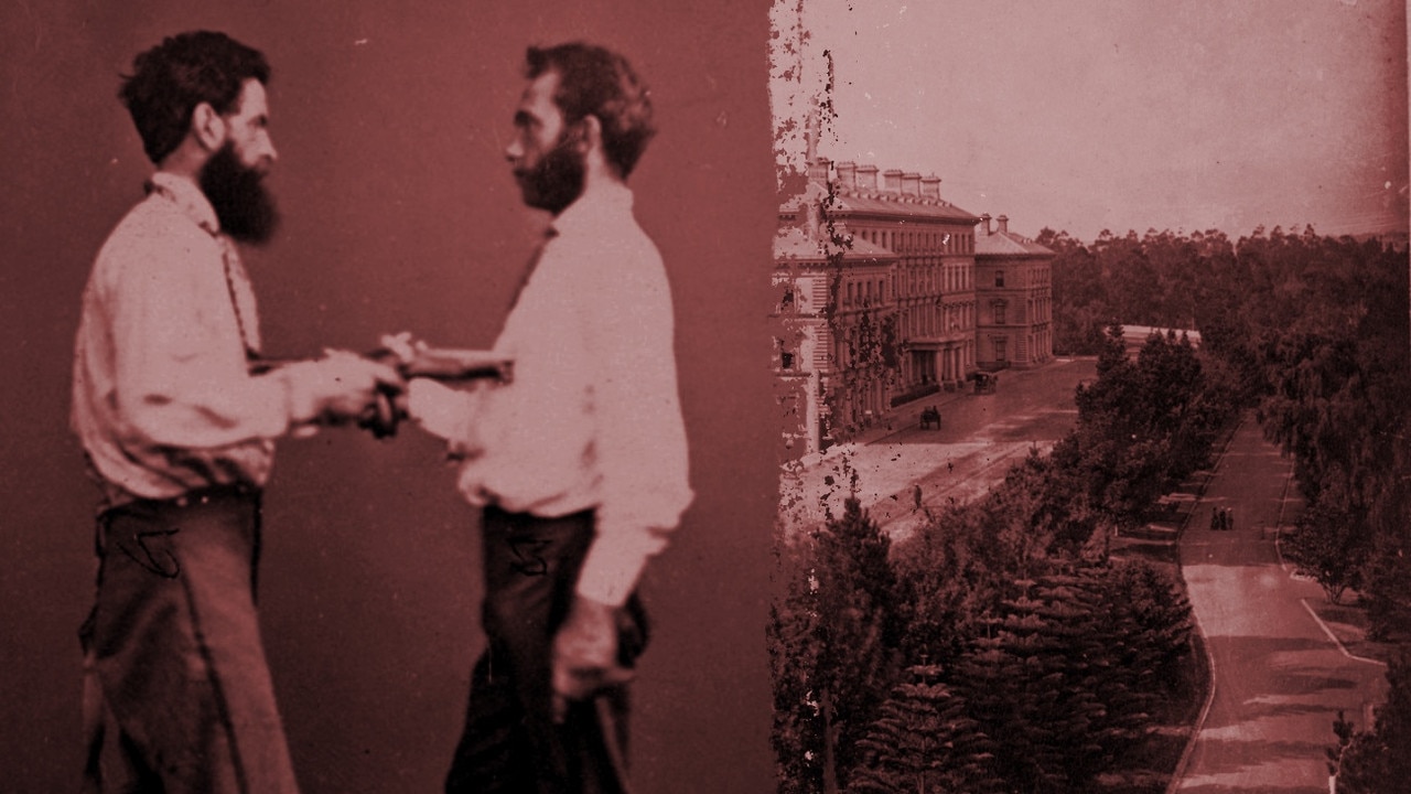
Was bizarre shooting suicide pact or murder?
Two men walked into a Melbourne photography studio one afternoon in 1872 to pose with their pistols in a bizarre series of pictures. Hours later a gunshot rang out in nearby Treasury Gardens and their true intentions became clear.

Why Curtis Stone wants to come home
Curtis Stone is the Keilor East boy turned celebrity chef who now lives in a multimillion-dollar house in one of Los Angeles’ coolest suburbs. So how does he show his young kids how to be everyday Aussies?