
Melbourne weather: Radar glitch creates cyclone eye of the storm near Laverton
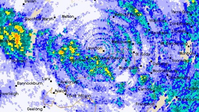
WEATHER radar watchers were left scratching their head when a bizarre formation formed over Melbourne last night that appeared to be a tropical cyclone, complete with an eye over Laverton. But not all was as it seemed.
VIC News
Don't miss out on the headlines from VIC News. Followed categories will be added to My News.
WEATHER watchers were left scratching their head last night at a bizarre formation over Melbourne, with a large rain system creating the appearance of a tropical cyclone.
The Bureau of Meteorology’s radar showed a huge system passing over Melbourne including an “eye” over the Laverton area.
RAIN OR SUNSHINE COULD BE ON THE CARDS FOR SUMMER
COOLER TEMPERATURES IN CITY BEFORE SUNNY WEEKEND
The radar created the impression that Laverton was in the eye of a tropical cyclone as rainfall moved across the region.
According to the @BOM_Vic radar there is a cyclone eye right over Laverton rn pic.twitter.com/aptaf7vJ1l
— Will Dawson (@willegitimate) October 24, 2017
BRILLIANT shot of a low right over Melbourne, with distinctive 'EYE' over Laverton just SW of Melb CBD. SEN-sational BOM 64km rain radar.. pic.twitter.com/GOkchUFDAz
— ⚡pinning (@TazSpinZone) October 24, 2017
Bureau of Meteorology senior forecaster Rod Dickson said the anomaly was simply a glitch with the bureau’s new radar system.
“We’ve upgraded our forecasting technology and some parts of the system are still being ironed out,” Mr Dickson said.
“It’s not that there isn’t any rainfall over the Laverton area.
“What we are probably seeing here is that the radar isn’t properly detecting rainfall that is happening directly above where it’s located.”
Laverton received the largest drenching in the Melbourne region, with 18mm of rainfall overnight.
Melbourne Airport and Melbourne’s Olympic Park weather station also recorded heavy rain - 12.7mm and 11.4mm respectively.
Moorabbin Airport was even wetter, with 13.4mm recorded.
Melburnians will face showers early this morning before rain eases into the evening.
It comes as the bureau issued a La Nina watch yesterday for Victoria for the coming summer.
The odds of our weather patterns being directly affected by La Nina have increased to 50 per cent, double the normal risk.
La Nina occurs when waters in the tropical Pacific Ocean cool and push warmer water towards Australia, bringing cloud and above-average rainfall.
The last La Nina period, from 2010 to 2012, was the wettest two years in Australia on record.
Read more: What is La Niña and how will it affect Australia?
Climate prediction services manager Andrew Watkins said if a La Nina weather system developed it would be weak and short-lived.
“And given the dry soils in large parts of south eastern Australia and no expectation of widespread rainfall, we’ve got to be careful not to be too complacent,” he said.
“The fire danger will still remain quite high particularly in the southeast.
“Weak La Ninas can actually bring heat into southeastern Australia, surprisingly enough, and a weak La Nina doesn’t wet up the soils enough so heatwaves and fires, you can’t write them off yet.”
Victorians should prepare for bushfires with parts of eastern and southern Australia facing an above-average bushfire risk this summer after one of the hottest and driest winters on record.
But in the meantime, Melburnians can enjoy sunnier conditions and occasional showers moving into the weekend as temperatures warm up to a maximum of 29C by Sunday.

‘Angels’: Hero Coles workers save mum’s life
A mother of three has opened up on how her life was saved after she suddenly collapsed while doing a routine supermarket shop.

Wildlife and traffic fears over music festival
Wildlife advocates fear a weekend music festival in central Victoria will endanger native animals including rescued joeys.