
Geelong weather: Forecast rain puts community groups on edge for more flooding
Flood-affected Geelong community groups are “on tenterhooks” over the possible impact of rain predicted for later this week, as authorities look to begin the clean-up.
Geelong
Don't miss out on the headlines from Geelong. Followed categories will be added to My News.
Flood-affected Geelong community groups are hopeful they can begin cleaning up on Monday as the Barwon River slowly recedes, but fear they may soon have to do it all over again.
The level of the water at the Geelong flood gauge was receding at an average of about 2-3cm per hour on Sunday, making for an agonising wait until the clean-up can begin.
The latest information from the Bureau of Meteorology indicates the water may not drop below the moderate flood level of 3.10m until the early hours of Monday.
Rowing Geelong president Sam Elliott said its clubs and members had been well-prepared for the event, although an upgraded warning late on Friday had some rushing to move equipment higher than first expected.
“We’ll probably find ourselves in a bit of silt and mud throughout the buildings and definitely the rowing reserves,” he said.
“In the next few days we’ve got to wait for the water to subside and we’ll get in there and get back into those sheds.”
The flooding means a Kardinia International College regatta scheduled for October 22 is now long odds to go ahead, and Mr Elliott was concerned it may be an even longer wait for rowing activities to resume.
Rainfall up to 30-40mm is predicted across the catchment later this week. The same amount just more than week ago caused minor flood warnings to be issued for the Barwon River.
About 50-70mm fell across the Barwon, Moorabool and Leigh river catchments between Wednesday and Saturday to cause the weekend’s flooding.
“We’re on a bit of tenterhooks again at the moment because they’ve predicted a little bit of rain again for the end of the week, so it depends on how heavy that is and where it falls as to if we’ll get another at least minor flood,” Mr Elliott said.
South Barwon Cricket Club was 20cm from disaster, with floodwaters stopping just short of their clubhouse.
Geelong mayor Peter Murrihy inspected the “quite extraordinary” extent of the flooding on Sunday and said for now it was a matter of waiting for the water to recede before council works teams got stuck into retify flood-hit community assets.
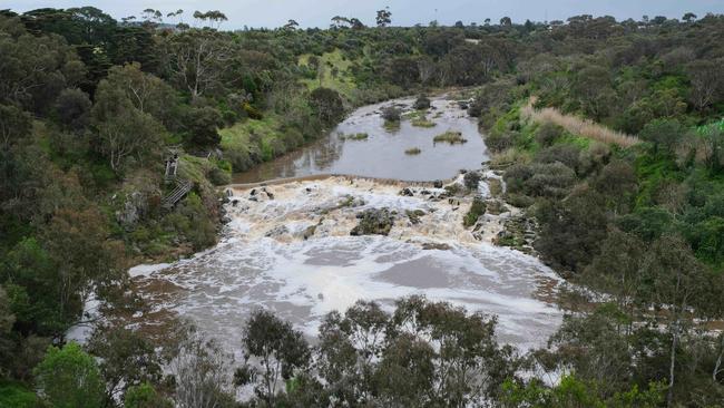
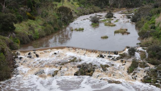
“The water flowing down through Buckley Falls and around Queens Park, it’s amazing to see the power of the water and it was still flowing pretty quickly,” he said.
“City works have been going all weekend and they’re across what’s happening and what needs to be done, but at the moment it’s just a wait and see.
“We’ll bounce back, we’ve been through it before, we know what needs to be done, so I imagine we’ll get our shoulder to the wheel and look after everybody and everything.”
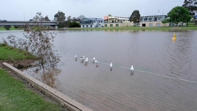
Works had already started at Landy Field, where water that came up through the venue’s drainage was being pumped away.
A Watch and Act warning remained in place for the Barwon River on Sunday.
“Flood water continues to flow down the Barwon River downstream of Geelong. Community members downstream of Geelong should not swim in the Barwon River,” the warning read.
As of 5pm Sunday, a number of roads were still shut down in part or in full due to flooding, including those at:
-South Geelong: Barwon Terrace between Swanston St and Wood St, including Gravel Pits Rd and Steel St
-Belmont: Barrabool Rd & Barwon Heads Rd
-Breakwater: Gundog Lane
-Marshall: Woolscour Lane
-Mt Duneed: Horseshoe Bend Rd between McCanns Rd & Blackgate Rd, Williams Rd between Whites Road & Dickins Road
-Freshwater Creek: Ghazeepore Road between Blackgate Rd & Dickins Rd, Pettavel Rd between Loutitt Bay Road & Dickins Rd
-St Albans Park: Wilsons Rd
-Mannerim: Knights Rd
-Lovely Banks: Bluestone Bridge Rd
-Lara: Rennie St, Windermere Rd between Mill Rd & Bacchus Marsh Rd, Flinders Ave between Windermere Rd & Branch Rd
-Anakie: Brownes Rd
-Inverleigh: Inverleigh-Shelford Rd between Hamilton Hwy & Bannockburn-Shelford Road
-Sutherlands Creek: Bakers Bridge Rd
-Winchelsea: Anderson St/Winchelsea-Deans Marsh Rd between Warner St and Cape Otway Rd
-Lethbridge: Perdrisat Rd
Earlier: Barwon River peaks Saturday
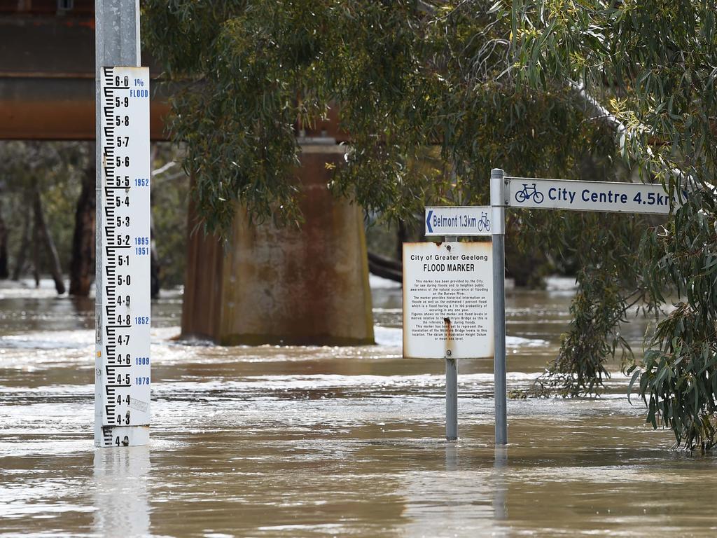
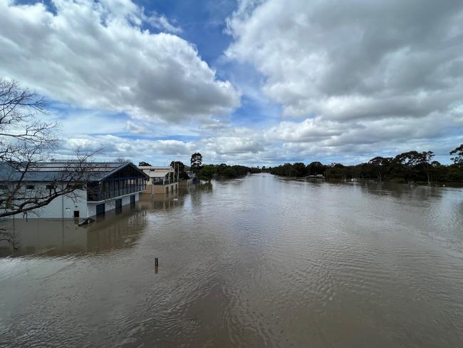
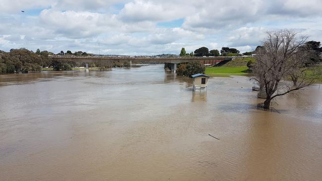
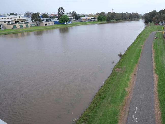
Water levels in the Barwon River are dropping as slowly as they rose after hitting a peak of 3.86m on Saturday.
The mark makes the 2022 event the highest the waterway has reached in Geelong this century.
The two other Barwon River floods since 2000 deemed “significant” according to the Victorian State Emergency Service were in January 2011 and April 2001, when the peak was 3.68m and 3.6m respectively.
But it pales in comparison to the previous flood in 1995, which peaked at a whopping 5.23m.
Other floods that eclipsed what is termed the ‘major’ flood mark (4.40m) include 1978 (4.5m), 1909 (4.6m) and 1952 (5.47m) — the latter considered the city’s most destructive river flood in recorded history despite falling short of a 5.8m flood recorded in 1880.
Some community infrastructure was inundated as the Barwon River neared its flood peak, sitting above 3.8m for almost eight hours on Saturday.
The city’s rowing sheds, athletics facility Landy Field, Belmont Common, Barwon Valley Golf Club and South Barwon reserve were among the venues inundated, while riverside business were also affected.
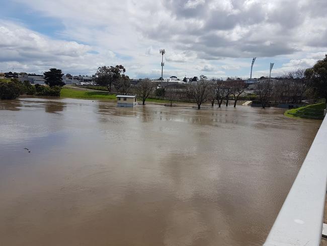
Geelong Athletics secretary Anna Devonish said it was “devastating” to see the extent of the flooding after river water came up through Landy Field’s drainage system.
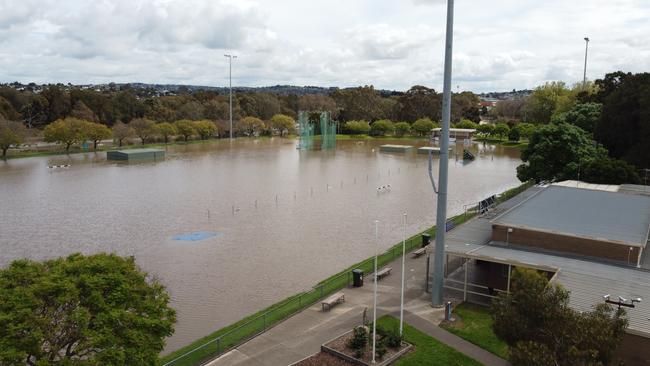
The water level was about 30-40cm above the track at its peak, and “one-third of the way up the pole vault cage”.
The Bureau of Meteorology said the water level in the river, which peaked at 3.86m at midday on Saturday, was expected to remain above the moderate flood level (3.10m) into Sunday.
A Watch and Act warning remained in place for the Barwon River on Saturday evening, warning people to stay out of floodwaters.
As of 6.30pm Saturday, a number of roads had been shut down in part or in full due to flooding, including those at:
-South Geelong: Barwon Terrace between Swanston St and Wood St, including Gravel Pits Rd and Steel St
-Belmont: Barrabool Rd & Barwon Heads Rd
-Breakwater: Gundog Lane
-Marshall: Woolscour Lane
-Mt Duneed: Horseshoe Bend Rd between McCanns Rd & Blackgate Rd, Williams Rd between Whites Road & Dickins Road
-Freshwater Creek: Ghazeepore Road between Blackgate Rd & Dickins Rd, Pettavel Rd between Loutitt Bay Road & Dickins Rd
-St Albans Park: Wilsons Rd
-Mannerim: Knights Rd, Queenscliff Rd
-Lovely Banks: Bluestone Bridge Rd
-Lara: Rennie St, Windermere Rd between Mill Rd & Bacchus Marsh Rd, Flinders Ave between Windermere Rd & Branch Rd
-Anakie: Brownes Rd
-Inverleigh: Inverleigh-Winchelsea Rd, Inverleigh-Shelford Rd between Hamilton Hwy & Bannockburn-Shelford Road
-Sutherlands Creek: Bakers Bridge Rd
-Winchelsea: Anderson St/Winchelsea-Deans Marsh Rd between Warner St and Cape Otway Rd
Rowing sheds on #BarwonRiver#flooding#Geelongpic.twitter.com/xhuR6YZGZT
— LewStew💉💉💉💉🦠🇦🇺 (@astewtwo) October 14, 2022
That’s a golf club. #BarwonRiver#Geelongpic.twitter.com/Sbjf2ksHuN
— Monique â˜˜ï¸ (@mnqmlny) October 15, 2022
Yep, last night I could drive down Barwon terrace, today on the way to work no way 😂 pic.twitter.com/FYJifU9jmA
— Zachary Sirg (@zaccy1996) October 14, 2022
Earlier: Two rescued on Friday
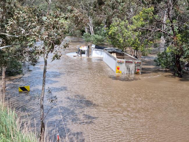
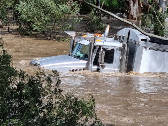
Two people have been winched to safety after attempting to cross the swollen Moorabool River.
Onlookers at Lethbridge and Maude were shocked to see a truck caught deep in the waterway, beyond multiple signs warning the road was closed, around 1pm on Friday.
“A 64-year-old man and a 69-year-old woman, both from Lethbridge were winched from their truck by the Victoria Police helicopter,” Victoria Police Senior Constable Alistair Parsons said.
“Neither occupants sustained any injuries as a result of the incident.”
Police did not say whether any charges would be laid.
A Victorian SES spokeswoman confirmed the road was closed at the time.
“SES volunteers were asked to attend a truck caught in floodwaters but due to the speed of the water there were unable to get in there, which meant the police airwing was called in to assist,” she said.
“The road was closed, and we would urge people not to tempt fate. Please do not attempt to drive through floodwaters.”
It was the second rescue at the Perdrisat Rd crossing for the day, with emergency services helping two people from the water around 9am.
The Barwon River burst its banks in the late morning with the waterway still hours from its peak, while a Watch and Act alert was issued warning people to avoid floodwaters.
By midday the river was at 2.56m, above what is considered the ‘minor’ flood level, which was enough to breach into parklands and pathways at Belmont Common and at South Geelong.
The Bureau of Meteorology warned the river was still rising, and predicted to peak at a ‘moderate’ 3.1m in the afternoon, putting low-lying areas at risk.
The Barwon River at Ricketts Marsh, west of Geelong, reached 6.31m to exceed the moderate flood level overnight, but is now rising again after dropping through the morning.
A swollen Leigh River at Shelford had locals under a Watch and Act alert on Friday morning, before it peaked at 7.82m around 8am, just below the major flood level.
Runoff also caused dramas for residents of Pintail Dr, Torquay bordering water storage for a nearby flower farm.

One resident told the Addy the water threatened about 20 homes in the street and resulted in SES spending about six hours on site in a bid to protect the homes from flooding.
It comes almost two years to the day 100 homes were evacuated due to fears a 180 megalitre dam on the flower farm property could collapse.
V/Line at 12.51pm released information to say trains were still operating between Southern Cross as far as Waurn Ponds.
The wet weather has caused the cancellation of all local cricket in the region.
Flooding risk remains for Friday, Saturday
Emergency services have called on Geelong residents to remain aware of flooding risks after heavy rains lashed much of Victoria on Thursday, as floodwaters from the north of the state travel south.
The SES issued a flood warning on Thursday night, declaring moderate flooding would be possible in Geelong as floodwaters headed downstream along the Barwon River.
“Heavy rainfall since Wednesday evening has caused stream rises along the Leigh, Barwon and Moorabool Rivers,” the warning noted.
“Minor flooding is occurring along Barwon River at Ricketts Marsh and likely to extend downstream.
“Minor flooding is likely from Friday afternoon along the Barwon River at Geelong, with moderate flooding possible at Geelong from Saturday morning.
“Minor flooding is possible along the Moorabool River at Batesford from Saturday morning.
“Further rainfall is forecast across the Barwon and Moorabool catchments for the remainder of Thursday into Friday, which could cause further river rises.”
Geelong received 41.2mm of rainfall on Thursday, according to equipment at the Bureau of Meteorology’s Geelong Racecourse site. More showers are forecast for the region on Friday.

Earlier: Geelong has been drenched on Thursday, with multiple properties in the region affected by flooding.
A Victoria State Emergency Service (SES) spokeswoman said the Geelong region crews had responded to 71 call-outs for assistance as of 6.30pm.
“The South Barwon unit had 16 (call-outs),” she said.
“Torquay had 16, Bellarine had 15, Corio had 13, and the Geelong unit had 11.
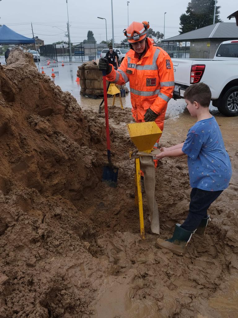
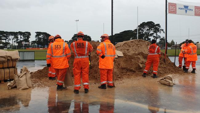
“Most calls have been for floods and requests for sandbags.
“Tree down calls have been about access issues.”
The Bureau of Meteorology’s Geelong Racecourse site recorded 22.2mm of rainfall between 9am and 6.30pm.
SES members at St Albans reserve in Thomson saw a steady stream of people coming to collect sandbags.
Waurn Ponds resident Hannah Lucas said she was grabbing about 11 bags to help her mother-in-law.
“Her garage is flooding because of a vacant lot next door,” she said.
“It’s like a swimming pool.
“She’s got no drainage so it’s just completely flooded.
“It’s coming through the wall (of the garage) now too.”
A SES spokesman said members from Geelong have been responding to a lot of jobs.
“There’s been a lot of requests for sandbags,” he said.
At the Bureau of Meteorology’s Geelong Racecourse site, about 28mm of rainfall had been recorded between 3am and 3pm Thursday.
Victorians were urged to defer all non-essential travel as extreme weather continued to affect the road and public transport networks across the state.
Coaches were replacing trains between Warrnambool and Geelong.
The transport department warned those conducting essential travel to allow extra travel time for affected journeys.
The Bureau of Meteorology was forecasting a high chance of showers for the Geelong and Surf Coast area on Friday, with a maximum of 17 degrees.
Road disruptions due to the weather included Surf Coast Hwy, Geelong-bound down to one lane near the intersection with Boundary Rd, and Bellarine Hwy, Queenscliff-bound.
SES responds to flooding
Emergency services are responding to more than 30 current incidents in the region, including a landslide on the Great Ocean Road, as heavy rains continue to wreak havoc across the state.
SES crews were facing 31 current call-outs across the wider Geelong region as of 1.30pm on Thursday, with the vast majority responding to flooding and building damage incidents.
The influx of call-outs came as 25.2mm of rainfall had been recorded between 3am and 1pm at the Bureau of Meteorology’s Geelong Racecourse site.
The Vic Emergency website issued a warning message shortly after 1pm on Thursday following a landslide on the Great Ocean Rd just north of the Separation Creek and Wye River townships.
“Stay informed. Stay away from the landslide. The slope may continue to move for hours or days afterwards,” the warning noted.
“Stay away from the impacted area to allow emergency services to help affected communities.
“Plan your trip in advance – travel may take longer due to closed roads and poor driving conditions.”
Earlier: Dozens of SES call-outs, ahead of rainfall peak
GEELONG region SES units have received more than 30 call-outs in the 24-hours to midday on Thursday, as flooding impacts the region ahead of forecasted increasing heavy rainfall.
The SES on Thursday confirmed crews in Geelong, Bellarine, Bannockburn and Torquay had attended 31 call-outs in the 24-hour period to midday on Thursday, with all but four of the call-outs relating to flooding assistance. At midday 19 of the call-outs had been cleared while 12 were still active.
Bannockburn felt the brunt of persistent rainfall, with the local crews attending 12 call-outs, followed by 10 by Geelong crews, six for Bellarine crews and 3 for Torquay.
Residents across the region have been warned to prepare for increasing rainfall throughout Thursday afternoon, with local emergency services expected to receive dozens more call-outs.
Earlier: Deluge begins, non-essential travel discouraged
Emergency services and residents across the region are bracing for heavy rains and expected flooding, as authorities release a series of safety warnings.
The Bureau of Meteorology recorded 7.8mm of rain at the Geelong Racecourse on Wednesday, amid the showers that were forecast to settle in across the region before intensifying on Thursday.
By 8.30am on Thursday a further 10.8mm had already been recorded, of a predicted 50mm expected to fall across the region during the day – with the highest rainfall rates predicted to occur from early-mid afternoon until about 4pm-5pm.
The Department of Transport issued a hazardous driving warning on Thursday morning, noting many roads across the state had already been closed by flooding and fallen trees.
“Driving conditions are extremely hazardous,” the warning noted. “Non-essential travel should be deferred.”
“Poor conditions make driving on major roads like the Hume Freeway, Northern Highway, Midland Highway and Calder Highway treacherous, particularly in northern areas around Seymour, Bendigo and Echuca.
“Water over the road has also been reported on the Melba Highway, Yea, the Hume Freeway, Beveridge, the Calder Highway, Bendigo and the Maroondah Highway, Buxton.
Several local roads are impassable, while others are cause for concern as flood waters move through.
“This dynamic situation is set to continue. Conditions can change quickly. Motorists are strongly encouraged to defer travel until conditions improve.”
The SES is distributing sandbags at 203 St Albans Road, Thomson (St Albans Recreation Reserve).
EARLIER: Geelong prepares for deluge
Geelong is on flood watch, with residents urged to stay indoors and prepare ahead of significant rainfall forecast for Thursday.
The Bureau of Meteorology predicts up to 50mm of rain could fall across the region, with the heaviest falls expected early in the afternoon.
Forecaster Miriam Bradbury said “patchy showers” would begin to develop late on Wednesday and would build to heavy falls.
The City of Greater urged residents to prepare for potential flash flooding, with sandbags available for collection from St Albans Recreation Reserve between 9am and 7pm.
“Essentially (the region is) starting to see some showers developing today, there is already quite a bit of shower activity in the area,” Ms Bradbury said.
Ms Bradbury said showers would remain scattered for most of Wednesday, with about 5-10mm expected to fall.
“It’s still Thursday that we are looking at those higher falls in the gauges, we expect about 35-50mm,” she said.
Geelong last recorded more than 50mm of rain during a single day in April 2017.
“It will be a very wet day,” Ms Bradbury said.
“The highest rainfall rates are expected when the actual front moves through in the early-mid afternoon until about 4pm-5pm.”
Victorian State Emergency Service chief operations officer Tim Wiebusch urged people in flood-affected area to plan their travel.
“Large areas of flash flooding is expected on Thursday and then the possibility of major riverine flooding in multiple catchments,” he said.
“Please do not attempt to drive through flood water.”
City of Greater Geelong director of city services, Guy Wilson-Browne, said after-hours crews and emergency-management teams would be mobilised to respond as required.
The predicted deluge comes as five of Geelong’s six water reservoirs sit at capacity, and the region at 98.9 per cent overall — a figure not seen for at least a decade.
Premier Daniel Andrews said the state’s emergency services stood ready to respond.
But he urged everyone to make their own preparations for potential emergencies and have enough supplies on hand to last up to 72 hours.
Homeowners were told to clear their gutters and remove debris that could become missiles during the storms.
“We know that our catchments are full. We know that we’ve had record rainfall to this point and the ground is absolutely sodden,” Mr Andrews said.
“So even a minor amount of rain would be a risk in terms of flooding.
“But it’s not a minor rain event that we are forecasting.
There will be significant rainfall in certain parts of the state, and that’ll pose a flooding risk to communities in lots of different places.”
More Coverage


Originally published as Geelong weather: Forecast rain puts community groups on edge for more flooding

Geelong father raped teenage girl after party
A Geelong father drunkenly forced himself on a 17-year-old girl as she lay frozen in fear, a court has heard.
Read more

Barwon Prison wing due to reopen, cleared of gas leak
A notorious wing of Barwon Prison is finally set to reopen after an independent report declared it safe in the wake of what was feared to be a gas leak.
Read more