
River Murray in flood: New satellite images show extent of water here already as daily forecast is increased to 135GL
The Riverland doesn’t “have very long” to prepare for a huge amount of water flowing into the system – with new predictions increased to 135GL a day, up from 120GL.

SA News
Don't miss out on the headlines from SA News. Followed categories will be added to My News.
Riverland residents are racing to prepare for a huge onslaught of water coming down the River Murray, with new predictions of a peak of 135 gigalitres per day by early December, up from predictions last week of 120GL.
“This is the highest level we’ve seen since the mid-1970s, many people won’t have experienced this in the Riverland, so we need to make sure we’ve got everyone not alarmed, but alert,” Environment Minister Susan Close said.
“It is possible that that figure will go up with further rain events in Victoria.”
The state government will give local councils $3m to repair levees, especially around low-lying Renmark, in preparation for the floods.
More sandbag stations and a flood hotline are being set up, and the SES will hold community meetings in the next few weeks ahead of the predicted peak.
The SES is concerned about severe rain on Sunday, which is forecast to hit across the state. Heavy rain last week caused flash flooding in the Riverland after half the region’s annual rainfall fell in the space of just two hours on Monday.
REPLAY THE PRESS CONFERENCE
More rainfall in the northern parts of the Murray-Darling Basin will mean the higher flows will last longer, Dr Close said.
“It will mean that rather than there being a much higher figure, it will be that amount of water coming for a longer period,” she said.
SES CEO Chris Beattie said volunteers had responded to almost 300 incidents in the past week alone, with the hardest hit communities in the Mid North and Riverland.
Localised flooding along the Wakefield River, Lower Light and Goolwa River areas has been of highest concern.
More than 120,000 sandbags had been shipped to the Riverland this week, with more SES distribution locations in coming weeks. A flood hotline has been set up on 1800 362 361.
“Most of the towns in the Riverland sit above the flood-plain, but Renmark is the most exposed and that’s where we’re putting our attention first,” Mr Beattie said.
Levees surrounding Riverland towns are designed to withhold flooding of up to 210GL, similar to a flood that hit the area in the 1930s.
“At 135GL the levees will be doing their jobs, they are designed to prevent a 210GL flood event,” he said.
Mr Beattie said Renmark was likely to be worst-hit by floods and further increases in predicted flows could not be ruled out.
December’s forecast peak “did not leave a lot of time” for action, he said.
“The modelling doesn’t take into account the influence of any future rain events … it’s not beyond the realms of possibility that we would continue to see an increase in these forecasts if we see more rain on the eastern seaboard,” he said.
However, two major levees in Renmark have been deemed “not fit for purpose” – Hospital Bank and the Hale St, prompting $3m from the state government to repair them over fears they could crumble if water flows increase up to 130GL per day.
Dr Close called the rising river water an “evolving situation”.
“I think it’s likely it will be over the next days and perhaps weeks that we determine exactly where there are any other systems that need additional support,” Dr Close said.
“It may well be that water will be at an even higher level than the 135, that’s possible, if it does keep raining in the eastern seaboard ... So we don’t have very long but we do have the right people looking at it.”
Ms Close urged residents to use the Department of Environment and Water’s website to predict how potential flooding would affect their properties and prepare.
Ms Close said officials would meet with councils on Thursday afternoon to determine the distribution of funds but on-ground works had begun already.
Community meetings will also be facilitated by the SES in coming weeks to prepare residents for action.
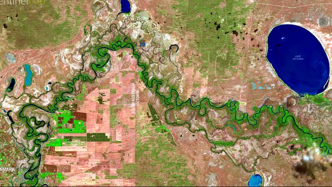
New satellite images reveal huge amounts of water in Murray
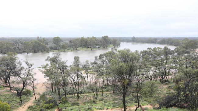
New satellite images of a sodden Riverland region show the remarkable amount of water that has already drenched the area.
The new satellite images, revealed by Mapping Services Australia, show a stark contrast between the amount of water in the system now compared to when the River Murray’s flow is at a normal level.
An image taken in June, 2020, when the river’s flow at the SA border was 5 gigalitres a day, shows a mostly dry region with water confined to the River Murray and a few select major lakes.
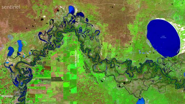
Another image taken this month, when the river’s flow at the border was more than 82GL a day, shows a markedly green region with backwaters and lakes filled to the brim.
Latest Department for Environment and Water advice forecasts the River Murray flow at the SA border will reach 120GL/day in early December. There is a “medium probability” it will reach 140GL/day and a “low probability” flows could reach 160GL/day
The flow will be the highest since 1974, when it was 180GL a day at the SA border. The 1956 flood, which was the largest recorded, peaked at 341GL a day at its worst.
More Coverage
Originally published as River Murray in flood: New satellite images show extent of water here already as daily forecast is increased to 135GL

‘Out of nowhere’: Council eviction risks beloved community club
A popular community club in Adelaide’s eastern suburbs is facing eviction – and possible closure – after council scrapped it without warning from its plans.

Nurse used SAPOL contract to dig up dirt, court told
A nurse contracted to SAPOL allegedly used its confidential systems to dig up dirt on a woman she was in a legal dispute with, a court has heard.