
Secret maps reveal plans for Coomera Connector through Daisy Hill koala forest
This is the map that Queensland’s Transport Department did not want the voting public to see before this month’s election. WATCH THE VIDEO


QLD News
Don't miss out on the headlines from QLD News. Followed categories will be added to My News.
A secret map of nine different routes for a second M1 highway has uncovered a possible plan for the road to cut through the Daisy Hill Conservation Park a major koala habitat.
SECRET DOCUMENTS SHOW RESIDENTS KEPT IN DARK
RESIDENTS DESIGN A NEW ROUTE AND SHOW MINISTER: SEPT 2019
STATE PROMISES TO REVIEW CONNECTOR ROUTE: OCT 2019
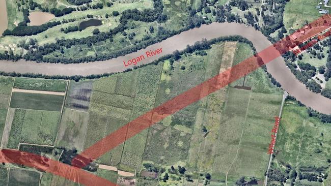
The map shows nine different routes for the northern section of the Coomera Connector with one possibility slicing through the park, a known koala habitat.
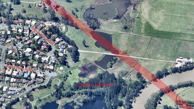
It was made public by Eagleby residents who have been lobbying the state government to promise not to plough the road through their community or the significant Eagleby Wetlands.
They have been asking the state Transport Department for details of the final route since October last year, when a review was announced.
The secret map was revealed the day after the federal government finally committed $762million for the first stage between Carrara and the Coomera Marine Precinct.
Springwood MP Mick de Brenni said there was no possibility “ever” that the highway would go through the state conservation area.
He said he had not discussed the possible Daisy Hill route with Transport Minister Mark Bailey because “it is not on the table”.
“This map is just not true. It will not happen. The second M1 goes from the Gold Coast to the Logan River. It does not go through Daisy Hill.
“Under no circumstances will it go through that area.”
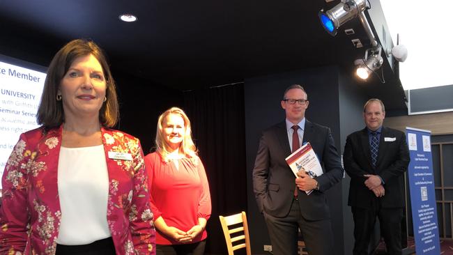
Mr de Brenni, along with LNP, One Nation and Animal Justice Party candidates slammed the mapped route cutting through the koala conservation forest at a forum for the seat of Springwood on Wednesday.
Eagleby residents revealed the map, which they paid $57 to obtain from secret state government files.
Eagleby Community and Wetlands Group Marilyn Goodwin said Mr de Brenni’s promise was not good enough.
“We want to know where the route is before we vote and we have been asking for this for nearly a year – what's the hold up?” she said.
“It’s absolutely ridiculous that we are going to the polls over this issue and we still don’t know where the final route is.
“The review was announced a year ago and still nothing – how long does it take?
“We have candidates who have all said that the route should not go through Eagleby.”
CHECK OUT OUR SPECIAL WINE OFFERS
SUBSCRIBE FOR $1: DEAL FOR LOGAN READERS
The map, which has “Not Government Policy” stamped at the top right-hand corner, shows the route the state approved in March last year before backflipping and pledging a review of the northern section through Eagleby.
The review followed a residents’ lobby group pushing for the six-lane highway to stay away from the Eagleby wetlands and their small township.
They drafted an alternative route, which they said would “save taxpayers millions” by cutting out two bridges.
The approved gazetted route circles Eagleby, clipping the Eagleby Wetlands before heading west back to the M1 behind the old Antiques site at Loganholme, where it then joins the Logan Motorway.
But for the first time, one of the maps shows a red dotted line tracking straight through the middle of the forest.
Mrs Goodwin said she knew the map was not government policy but until the route was finalised she was not stop lobbying.
Originally published as Secret maps reveal plans for Coomera Connector through Daisy Hill koala forest
Suspected lone L-plater, 19, in early morning crash that killed jogger
Police are investigating whether the driver of an out-of-control car that killed a woman on her morning jog was an unaccompanied L-plater. It comes as a nearby resident recounts the moment her body was found.
Safety questions after Bruce Hwy explosion that killed twin unanswered
The companies involved in the crash that killed a 21-year-old twin and blew up part of the Bruce Highway have failed to answer key questions about another recent near-disaster in Central Qld.