
Coomera Connector plan cuts out two bridges
Details have emerged of an alternative route for the controversial four-lane Coomera Connector highway which designers say will slash millions of dollars off construction costs by axing two bridges.
Logan
Don't miss out on the headlines from Logan. Followed categories will be added to My News.
DETAILS have emerged of an alternative route for the controversial four-lane Coomera Connector highway which designers say will slash millions of dollars off construction costs.
The proposed route would only need one bridge, as opposed to the three in the government’s gazetted plan.
Designers of the alternative plan unveiled the route when they met with David Greene, the senior policy adviser to Transport Minister Mark Bailey last week.

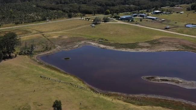
Eagleby Community and Wetlands Group chairman Marilyn Goodwin and seven community representatives said their route would save taxpayers millions by not having to build two bridges.
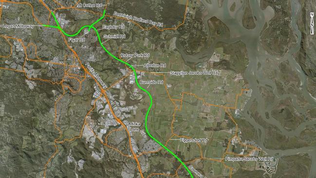
Their proposed route will be similar to the state government’s from Nerang to Stapylton Rd and Jacobs Well Rd.
However, it differs from the gazetted road as it does not cross the Albert River and is further east of Alberton Rd, to avoid Eagleby.
The residents’ proposed route would cross the Logan River at Ferry Rd, Carbrook, 4km east of Skinners Rd, where the state government’s plan included one of the three bridges.
“The government’s plan circles Eagleby and is on flood plain which is high in acid sulfate and creates sulfuric acid which eats concrete and kills fish,” Mrs Goodwin said.
“Our plan goes to the east of Eagleby, away from the wetlands and endangered wildlife and is on higher ground through disused cane fields.
“It will not need bridges at Wharf Rd-Skinners Rd or at Keogh Rd at Stapylton.”
Mr Greene listened to the proposal and said he would pass on the plans to Mr Bailey but warned that changes were unlikely.
Macalister MP Melissa McMahon, who was at the meeting, said she was “not sure” if turning Beenleigh-Redland Bay Rd into a four-lane motorway was a solution.
“There are a lot more properties to resume, including schools,” she said.
“They also seem to think that Beenleigh-Redland Bay Rd connects to the Logan Motorway, which it does not.”
Residents have also started a second petition calling for a review of the route and asking for it to avoid Eagleby.
Already 1195 people have signed the petition which residents hope will be tabled in parliament.
Residents gathered at a site in Eagleby this month to form a human chain to measure out the width of the government’s proposed road.
GOVERNMENT ROUTE
■ From Staplyton-Jacobs Well Rd near Alberton Rd, the road heads north to cross Rotary Park Rd.
■ It swipes Yellowood Rd, Enkelmanns Rd and Palmcrest Rd before crossing the Albert River into Eagleby south of Riverhills Rd.
■ It does not touch the Eagleby Wetlands, running east of Maurice Park.
■ It skirts the southeastern boundary of Palm Lake Resort clipping properties on the corner of Fryar Rd and Eagleby Rd.
SUBSCRIBE FOR MORE CONNECTOR NEWS
■ Parts of 18 acreage properties on Eagleby Rd, opposite Palm Lakes Resort, are earmarked for resumption.
■ The road continues east, crossing Schmidt Rd between Sharon Dve and Eagleby Rd.
■ But it does not touch the Eagleby State School or the mapped area for Eagleby Wetlands and only affects four properties at Palm Lakes Resort.
■ It is at that point, on Eagleby Rd, where the Coomera Connector Road splits, with one section heading north across eight acreage properties before crossing the Logan River to Carbrook, where it links up to Beenleigh-Redland Bay and Mt Cotton Rd.
■ The road splits with the other section heading west following Eagleby Rd to the Logan River where it crosses north of Herses Rd to run through the middle of the Logan City Council property, once designated for a zoo and more recently a wave park.
■ The road then joins to the M1 heading north.

Man charged after alleged ute hit and run leaves man critical
A man has been charged after he allegedly hit a 40-year-old man with his ute leaving him with critical injuries, south of Brisbane.

Mapped: The Qld towns, suburbs banks are abandoning
Banks are shutting down branches across Queensland at an alarming rates, with some towns completely abandoned. INTERACTIVE MAP