
NSW Floods: Severe weather warning after NSW cops deluge
Evacuation orders have been put in place across multiple towns in NSW. Others are on high alert. Read the latest.
Local
Don't miss out on the headlines from Local. Followed categories will be added to My News.
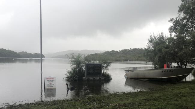
Premier Dominic Perrottet says Manly Dam is spilling and an evacuation order affecting thousands of people is set to be made.
The dam is located in Manly Vale, on Sydney’s northern beaches, and the pending order will affect 800 homes and about 2000 people.
Northern Beaches Council says the Freshwater Surf Life Saving Club is open for people whose homes have been inundated.
The amber alert for the dam comes shortly after a red alert for an evacuation had been announced by the State Emergency Service.
SES Commissioner Carlene York announced the new order this afternoon and said it would affect thousands in the area, before it was downgraded.
“Today we are issuing another evacuation order for the area around the Manly Dam,” Commissioner York said.
“Today we are issuing another evacuation order for the area around the Manly Dam...it does affect about 800 homes and 2,000 residents. The dam is currently spilling but I am informed by the engineers that the dam itself is safe.”
Shortly after the SES tweeted that the alert had been downgraded to amber as “there has been a drop in water levels”.
Sydney’s north has seen a deluge of rain today, with 122mm falling at Mosman in the six hours to 1.30pm.
Residents in low lying areas around Manly Vale and North Manly have had to be rescued by the SES.
Pittwater Road becomes Pittwater river with flooding in Dee Why #sydneyfloods#deewhy#northernbeachespic.twitter.com/9E9hFQu91N
— Road Less Travelled (@rdlesstravelled) March 8, 2022
Multiple NSW suburbs and towns were also ordered to evacuate urgently before it was too late for emergency services to help them if they were cut off without power.
NSW SES is now directing people along the Hunter River within Glenridding Dunolly and Combo to evacuate the high danger area.
Once floodwater passes 12.80m on the Singleton gauge at Glenridding Dunolly and Combo roads will begin to close.
The areas affected are low lying areas of Glenridding and Dunolly including south of Victoria St, Army Camp Rd to the rail line, and west to Putty Rd including Hueston Ln.
There are evacuation centres at Singleton Diggers, Singleton Heights Sports Centre and Singleton Heights Public School.
Parts of Mulgoa are now subject to evacuation orders advising them to leave by 6pm tonight, including all properties on the western end of Martin St between the Nepean River and Mulgoa Creek.
Huge downpours in front of our office in Manly this morning. pic.twitter.com/w7AfOdtYjD
— 🌠Zali Steggall MP (@zalisteggall) March 8, 2022
On the state’s mid-north coast, the NSW SES is directing people within Kempsey CBD, Eden St and areas east of the railway line north up to Frederickton to evacuate the high danger area.
Multiple streets on the Lower Macleay including South West Rocks Rd, Smithtown Rd, Plummer’s Ln, South West Rocks, Crescent Head, Hat Head, Maria River Rd and camping grounds at Delicate Nobby, Point Plummer and Racecourse are also ordered to evacuate.
In Camden, Exeter St west of John St and Milford Road in Camden West have both been ordered to evacuate this afternoon.
Multiple other streets in Camden were earlier ordered to evacuate, including Mitchell St, Elizabeth St, Argyle St and Lerida St.

Parts of St Georges Basin and Sussex Inlet on the state’s south coast were also ordered to evacuate due to rising floodwaters.
Areas in Sussex Inlet ordered to evacuate include River Rd, Cater Cres, Banksia St, Fairview Cres, Nielson Ln, Wunda Ave, Jacobs Dr, Poole Ave, Ellmoos Ave and Sussex Inlet Rd.
The affected areas in St Georges Basin include The Park Dr, Mountains St, Larmer Ave, the eastern side of Fairway Dr, Walmer Ave, Sanctuary Point Rd, Old Erowal Bay, Page St, McGowen St, Prentice Ave, Island Point Rd, Graham Ave and Loralyn Ave.

It follows earlier evacuation orders for low-lying areas on the Georges River including Sandy Point, Pleasure Point, Picnic Point, Holsworthy, Warwick Farm, Moorebank, Milperra, Georges Hall, Liverpool and Lansvale.
More heavy rainfall and damaging winds are expected to batter the east coast of NSW from the Mid-North Coast to the Victorian border following a late night deluge that left roads and public transport in chaos.

On Monday 100mm of rain dumped on parts of Sydney with the Bureau of Meteorology forecasting more heavy rain, winds of 90km/h and likely flash flooding on Tuesday.
“A low pressure system is expected to deepen and develop into an East Coast Low near the Hunter Coast this morning and track south,” the bureau said in an alert,
“This system is forecast to bring Heavy Rainfall and Damaging Winds across the central and southern coast, ranges and hinterland.

The warning is in place for the Mid North Coast, Hunter, Sydney Metropolitan, Illawarra, South Coast, and parts of the Central Tablelands districts.
“Six-hourly rainfall totals between 70 to 120mm are possible. Heavy rainfall areas will gradually contract from the north during the day, with the peak of the rainfall most likely about the Sydney Metropolitan, Illawarra and South Coast districts.
It has been combined with a separate severe weather warning for Damaging and Hazardous Surf in the Hunter, Sydney, Illawarra and south coast.
Other regions including Coffs Harbour, Kempsey, Coonabarabran, Port Macquarie, Taree, Goulburn, Tamworth and Gunnedah should also be on alert.
Sydney motorists and commuters have been told to avoid all non-essential travel with flash flooding set to create chaos on roads and public transport.
Manly Dam spilling this morning. Thats my office just downstream #sydneyfloodspic.twitter.com/12uPVxXNum
— Mitchell Harley (@DocHarleyMD) March 7, 2022
As flooding continues across the state, NSW Maritime is warning boaters to stay ashore with water ways filling with dangerous debris.
Giant wheelie buns and other obstacles have been spotted, making the going dangerous for water craft.
Wild conditions and strong currents are making debris a navigational hazard.
A garbage bin was spotted in the water near Long Bay in Sydney with a port marker with logs and debris attached seen near Dangar Island on Monday.
On Tuesday morning an alert was issued about debris in the Crookhaven River around Greenwell Point in the Shoalhaven.
Wild weather is also wreaking havoc across roads on the east coast of NSW, forcing multiple closures.
SOUTHWEST SYDNEY
Evacuation orders remain in place for parts of Camden and Picton , with residents urged to leave or risk being without power and isolated from 9pm on Monday.
Macarthur residents battened down the hatches as intense rainfall and storms moved across the region on Monday night.
Evacuation orders remain in place for parts of Camden, while an evacuation warning is in place for some streets in Camden and also Picton CBD.

At 9.53pm, emergency services received calls to people trapped in cars on Menangle Rd Campbelltown.
The SES also issued an alert for the possibility of major flooding on the Georges River near Liverpool.
It follows flash flooding around Milperra on Monday, with images showing cars submerged on Canterbury Rd.
The BoM said there had been 86mm of rain in the two hours to 9.30pm at Lucas Heights.
A huge thunderstorm also caught the city off-guard overnight, with multiple suburbs told to evacuate on short notice.
That includes residents of the low-lying parts of Chipping Norton, Georges Hall, Holsworthy, Lansvale, Milperra, Moorebank, Warwick Farm, Picnic Point, Pleasure Point, Sandy Point and East Hills.
The Georges River, which was predicted to rise to 2m at midday today by the Bureau of Meteorology, reached 4.39m at the Liverpool Bridge this morning.
The BoM also warned of potential major flooding at the Georges River at Liverpool and moderate flooding at Liverpool.
Milperra Public School will not be operational on Tuesday as a result, the school confirmed.
Shocking social media video showed cars floating in flood waters near Bunnings Bankstown Airport on Milperra Rd.
“Very heavy rainfall over the Georges River catchment over the past few hours has the potential to cause major flooding at Liverpool early Tuesday morning,” the BoM said.“The Georges River at Liverpool Bridge may reach the major flood level of 4.5m around 3am Tuesday and further rises are possible.”
A Fire and Rescue NSW crew also obtained extraordinary footage of the moment a flash flood tore through a number of houses last night at Birrong.
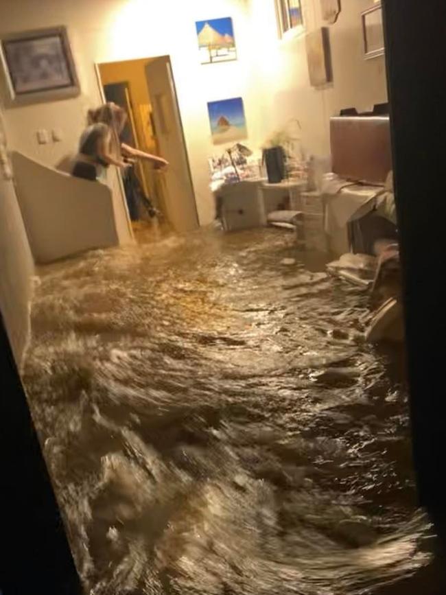
The crew, from Rhodes Fire Station, attended three homes in Larien St just after 7.30pm when the flash-flooding occurred without warning.
The waters were strong enough to burst open the front door of one home, rushing along the corridor, collecting furniture and belongings along the way.
The knee-high water quickly carried the possessions to the back yard.
The stunned residents of that home filmed the water on a mobile phone as it rushed through their rooms.
The rear corrugated iron fence of the property next door was torn apart by the floodwaters, with debris ending up near the adjacent railway line.
The firefighters turned off the power supply to the homes, removed compromised power boards and helped residents to bail out as much water as they could.
HAWKESBURY
The SES is warning of major flooding on the Upper Nepean, Nepean, Colo and Hawkesbury rivers with “higher or similar” water levels to last week.

As of 7am, major flooding was being experienced at parts of Menangle, North Richmond, Wisemans Ferry and Putty Rd
“Heavy rainfall over the past week has caused major flooding in the Hawkesbury-Nepean Valley,” a statement from the SES said.
Further heavy rainfall over the weekend and Monday into Tuesday has the potential to cause
renewed and higher flooding along the Upper Nepean, Nepean, Hawkesbury, and Colo Rivers.
The Nepean River at Menangle Bridge peaked at 15.91 metres around 1am Tuesday, with major flooding above last year’s event. The river is currently at 15.87 metres and steady, with major flooding.
The Nepean River at Camden Weir may peak near 11.90 metres around 8am Tuesday, with moderate flooding.
The Nepean River at Wallacia Weir may exceed the major flood level (11m) Tuesday evening.
The river level may peak near 12.00 metres overnight Tuesday into Wednesday, with major flooding.
PENRITH
Constant rainfall has seen the Nepean River rise once more, with ‘moderate’ flooding taking place at Penrith.
In western Sydney major flooding is taking place along the Hawkesbury River at North Richmond, Lower Portland, Wisemans Ferry and Sackville, as well as along the Colo River at Putty Road.
This is Werrington near Penrith from the train! #SydneyStorm#weather#sydneyrain#sydneyweatherpic.twitter.com/UgV6Sgis1y
— Yasmina Rifai (@yasminabanana) March 7, 2022
The wet weather has caused havoc in the region’s roads and public transport system with Blue Mountains line trains not running between Penrith and Lithgow due to a landslip near Zig Zag.
Several parts of Penrith, Londonderry and Jamison are still on high alert for possible evacuations as the Nepean continues to swell.
PARRAMATTA
Police have described the discovery of bodies suspected to be a mother and son in a Wentworthville stormwater canal as a tragedy. They were found a kilometre from an abandoned car.
Two bodies have been found in Sydney’s west near where a car was discovered abandoned in a stormwater canal.
Police found the bodies of a man and woman on Tuesday morning after putting out the call for information on the whereabouts of Hemalathasolhyr Satchithanantham and her adult son, Bramooth.


A white Mazda appears to have lost control on Cumberland Highway and crashed through a fence along the waterway before landing in the stormwater drain.
A large section of the fence is missing where it is believed the car careened down the steep concrete wall into the fast flowing water.
About 8.20am on Tuesday, a woman’s body was found in the creek near Hopkins St at Constitution Hill — 1.4km from the crash — and the man’s body was found 900m from the initial site.
The bodies are yet to be identified but sources believe the pair is the missing mother, 67, and her 34-year-old son.

Cumberland commander Detective Superintendent Paul Devaney said the Satchithananthams’ Mazda 3 was found submerged in the Coopers Creek Canal where it crashed into on Monday afternoon.
Police are yet to determine when the car was washed down the culvert. “We have had a number of witnesses come forward,’’ Det-Supt Paul Devaney said.
“However it’s in the infancy of the investigation and we’re yet to determine an actual time of the incident.’’
NORTHERN BEACHES
A fierce early morning downpour has inundated cars and sent garbage bins and rubbish floating down a northern beaches street.
Blocked and swollen stormwater drains overflowed in Kangaroo Lane in Manly just after 8am, trapping water close to 1m high.

A number of vehicles were inundated with stormwater.
Several wheelie garbage bins were also set afloat, spilling their contents into the swirling water.
A resident, who lives nearby, said the drains around Kangaroo Lane regularly overflow during heavy rain.
“You’d think the council would have sorted all this out before this bad weather, wouldn’t you,” the resident said.
In the three hours from 9am, more than 32mm had fallen at the Weather Bureau station at Terrey Hills. The same amoiunt was also recorded at Mona Vale in the same period.Flooding was also seen on Warringah Golf Course at Manly Vale with water surging across busy Kentwell Rd, affecting morning peak hour traffic.
EASTERN SUBURBS
The eastern suburbs have expectedly not had the flash flooding seen across other parts of greater Sydney, but the area still has its own weather-related issues to deal with today.
With violent wind and rain hitting the coast, The Bureau of Meteorology has issued a hazardous surf warning for Sydney beaches until at least midnight tomorrow, Wednesday March 9.
In a Facebook post, Waverley Council encouraged people to stay away from the popular swim spots.
“Our Manager of Lifeguard Services, Matt du Plessis, said large and powerful surf conditions are expected to be hazardous for coastal activities such as rock fishing, swimming and surfing,” the council wrote.
“As a general precaution, swimming at ocean beaches should be avoided for up to one day after heavy rainfall or for as long as stormwater is present.”
Bunnings Eastgardens car park. #nswweather#nswfloods#sydneyrain#sydneyfloodspic.twitter.com/vsrwmdl1VX
— Djuro Sen (@DjuroSen) March 8, 2022
However, heavy rain has caused some minor flash flooding in the southern side of the eastern suburbs, including at Bunnings in Eastgardens.
INNER WEST
Marrickville and the inner west copped a lashing of rain and thunder last night as the Cooks River broke its banks, flooding the Marrickville Golf Club and surrounding areas.
At about 10pm last night heavy rainfall increased in the area as parts of the flood-prone suburb again went under water.
Carrington Rd in Marrickville saw another flash flood with the road submerged as police attempted to shepherd people onto other routes.
Bayview Ave near Gough Whitlam Park was also under water.

Towards Earlwood, the Cooks River broke its banks and astonishing photos from the SES Marrickville Unit show it engulfed large parts of the Marrickville Golf Club and the riverbank footpaths.
Wardell Rd also experienced flooding: two cars stalled in the deep water and have been left abandoned on the road, with cars and buses attempting to manoeuvre around the vehicles earlier today.
As at 8am this morning, the areas affected overnight were comparatively more dry with the localised flooding subsided.

But the SES have issued another alert and more rain is expected to hit the inner west.
“The heavy downpour last night has led to localised flooding across streets and parks in many areas in the inner west,” the SES wrote in a Facebook post.
“The downpour is expected to continue throughout today and could be much heavier than last night.
“We would like to urge residents to avoid driving through or entering flooded streets, to move their vehicles to higher ground and to tie down any loose items in backyards and balconies.”

SOUTHERN HIGHLANDS
Emergency services in the Southern Highlands responded to nearly 100 requests for help on Monday as the worst flood in decades swept through the region.
While the majority of the calls were for leaking roofs or sandbag requests, the NSW State Emergency Services (SES) Wingecarribee Unit conducted four flood rescues.

A SES spokesman said it’s the most damaging and widespread flood he’s seen in more than 30 years of living in the area. Mittagong was drenched by 231mm of rainfall in the 24 hours before 9am on Tuesday – one of the highest totals in the whole of NSW.
On Tuesday, the concern is for the predicted triple figure rainfall of around 150mm in the Southern Highlands, which is expected to materialise on Tuesday afternoon.
SES volunteers, police, and Rural Fire Service crews were stationed at flooded roads to redirect traffic and stop foolhardy locals from attempting to cross the rushing water.
One young man was seen trying to square up to a police officer on Rose St as he attempted to wade through the fast-flowing stream that was more than 1.2m deep. Although he was eventually dissuaded, he was not the only one to think he could brave the waters.
ILLAWARRA AND SOUTH COAST
Hundreds of residents have been ordered to evacuate from their homes in Sussex Inlet and St Georges Basin in Shoalhaven by midday amid fears flood peaks will leave homes isolated.
The order was given by NSW SES shortly after 11am on Tuesday, with homeowners on 23 roads in the region being affected.
Streets were empty and houses deserted in the popular bay side area of Sussex Inlet in Shoalhaven only hours after evacuation orders were issued.
NSW SES told residents of Sussex Inlet and neighbouring St Georges Basin to leave by midday on Tuesday or risk being left stranded and possibly without power.
The warning comes as local catchments overflow after receiving more than 120mm on Monday, with an additional 200mm or more forecast for Tuesday.
Floodwaters swept over a streets in Sussex Inlet, which had become a ghost town.
Shelters have been set up at Sussex Inlet Bowling Club and Bomaderry Bowling Club.
NSW SES warned that once floodwaters enter St George Basin, properties will be flooded.
“Road access will be lost, as well as sewerage lines and power to the area” according to NSW SES.
“If you remain in the area after midday, you will be trapped and it may be too dangerous for NSW SES to rescue you.”
In Sussex Inlet, residents were warned once the flood levels reach 1.4m, parts of the area will be isolated, possibly without power.
The full list of affected roads in the area are River Rd, Cater Crs, Banksia St, Fairview Crs, Nielson Ln, Wunda Ave, Jacobs Dr, Poole Ave, Ellmoos Ave, and Sussex Inlet Rd.
In St Georges Basin, the affected roads are The Park Dr, Mountains St, Larmer Ave, the eastern side of Fairway Dr, Walmer Ave, Sanctuary Point Rd, Old Erowal Bay, Page St, McGowen St, Prentice Ave, Island Point Rd, Graham Ave, and Loraylin Ave.
Residents in areas nearby to those affected are advised by NSW SES to be on alert.
The busy Princes Hwy in Ulladulla has been closed by rising flood levels as the south coast and Illawarra regions continue to grapple with heavy rainfall and severe storms.
The closure is between Hollywood Ave and Kissing Point Dr in the popular tourist town, an area which most mornings is usually full with cars travelling between the region’s main towns, including Batemans Bay and Nowra.
Heavy rain over the Bega River catchment since Monday evening has also caused minor flooding along the Bega River at Bega on Tuesday morning.
SUTHERLAND SHIRE
The low-lying town of Woronora has continued to avoid significant flooding as poor weather conditions continue, and their neighbours in Sandy Point were forced to evacuate overnight.
Sandy Point and a number of low-lying areas along the Georges River were ordered to evacuate at 1am on Tuesday as the river began to flood at multiple points which included Milperra, Picnic Point, Georges Hall and Holsworthy.
The Woronora Rural Fire Service Brigade said conditions remained poor on the Woronora River, with all residents advised to stay off the river unless their property can only be accessed by water.
Video showed water flooding into The Boatshed at Woronora, while the RFS reported fast moving water was continuing to spill from upstream at The Needles in Engadine.
However, the Boatshed has already cleaned up and is now serving up bacon and egg rolls and coffees takeaway only to boost community spirits ahead of high tide this afternoon.

Multiple homes on low-lying streets in Kurnell are now experiencing minor flooding, with the NSW SES, NSW RFS and NSW Fire and Rescue assisting by pumping water out from homes.
Residents on Torres St and Captain Cook Dr had water lapping at their doorsteps, with garages, granny flats and backyards going under the water.

On Torres St, resident Natalie was among those with water on the back doorstep and several feet of water over her entire back yard.
“We’ve only been here a few months,” Natalie said.
“It’s not great but my husband’s from Ballina, we’ve got family in Ballina – this is nothing compared to what they’re going through.”

There was similar sentiment on Captain Cook Dr near Kurnell Rural Fire Service headquarters, where more homes were in a similar position.
Partners Bianca and Kieran have lived in Kurnell all their lives – but have never seen anything like this at their home of 11 years.
“I’ve been crying today, my granny flat’s damaged, but I’m just thinking about the poor people whose actual houses are completely flooded,” Bianca said.
“We’re so low lying here, you can see the road is higher than the houses, and the drainage is completely inadequate – combine the high tide and the amount of rain we’ve had, there’s nowhere for the water to go,” Kieran added.

In the interests of public safety, all Sutherland Shire Council-maintained playgrounds will be closed until further notice.
“With the continued heavy rainfall, there is an increased risk of unstable ground and tree failure,” the council said in a statement.
“Arborists engaged by Council have commenced a comprehensive assessment of the health and stability of trees near our playgrounds.”

Areas will be taped off and inspections will be conducted on high-risk trees around the council’s parks.
“Trees and branches that are deemed to be at risk will be safely removed as soon as weather conditions allow,” the council stated.
“We ask you to please stay away from parks while heavy rainfall persists, and we look forward to welcoming everyone back to our parks and playgrounds as soon as it is safe to do so.”

NEWCASTLE AND THE HUNTER
Evacuation warnings have been made to some low-lying and semirural landholders near Singleton and Maitland as the Hunter’s rivers continue to swell from the big wet.
Significant falls of almost 100mm have been recorded in pockets of the Hunter in the 24 hours to 9am on Tuesday, although Newcastle and surrounds only received less than 20mm.
The Bureau of Meteorology reported about 9am on Tuesday that the Wollombi Brook at Bulga was approaching a major flood peak.
Wollombi was approached a minor flood level peak although further rises remained possible.
There was minor flooding occurring along the Lower Hunter River at Maitland and was expected at Singleton, with major flooding still “possible” and moderate flooding also possible at Maitland.
CENTRAL COAST
Heavy rainfall is causing chaos on Central Coast roads as flood warnings remain in place.
A salvage operation is underway after a multi-vehicle crash on the M1 during the heavy downpour on Tuesday morning.
Just before 7am, a number of vehicles including two trucks collided near Ourimbah causing a B-double to roll just past the Peats Ridge exit.
A NSW Ambulance spokesman said five crews attended the scene and assessed three patients, with one classed as serious and two minor.
He said two patients were taken to Gosford Hospital, including a male aged in his late teens with serious injuries.

Traffic remains heavy as the northbound lanes will have intermittent closures as the salvage operation continues throughout the morning.
The Bureau of Meteorology stated that a “low pressure system is expected to deepen and develop into an East Coast Low near the Hunter Coast this morning and track south”.
Major flooding warnings are in place for Hawkesbury River towns such as Wisemans Ferry and Spencer.
Tuggerah Lake at Long Jetty is currently at the minor flood level of 1.06m with a moderate warning as rain continues.
Broken Bay Water Police have issued a safety warning to local boat owners to take extreme caution, and avoid non essential boat travel, due to debris in the Hawkesbury River, Cowan Creek and Pittwater.
NORTH SHORE
Several business owners on the north shore have been left counting the cost after a section of road and retaining wall collapsed during Sydney’s wild weather conditions.
Emergency crews were called to Castle Cove this afternoon after a section of Deepwater Rd in Castle Cove washed away due to the severe weather.
Fire and Rescue NSW said a large amount of water flowed into some of the shops, severely damaging premises.


Michael Tan, who works at Castle Cove Convenience Store, said the clean-up effort was continuing as of 3.30pm.
“The back sections of the building couldn’t take the rain pressure and the roof came down,” he said.
“All the shops got damaged altogether and we got flooded out.
“We’ve been pumping water out this afternoon but it’s going to take a while (to clean up).
“We managed to save most of the stock, but all the dinks are damaged.”
Fire and Rescue NSW said the area was evacuated with an exclusion zone also set up.
The State Emergency Service also assisted with the incident.

U19s NRL pipeline: Staggering numbers show NSW’s dominance over Queensland
New South Wales has long done the heavy lifting in producing NRL talent, and the latest stats prove that. See the staggering State of Origin U19s numbers showing just how many make the grade.

One of four teens accused of filming six-hour rape named
Four teens have been charged over the alleged six-hour sexual assault of a 17-year-old girl in Sydney’s west, with police alleging they filmed snippets of the ordeal and shared them with each other.