
NSW floods: Evacuation order for Camden as southwest Sydney on high alert
From the western suburbs to the inner city, torrential rainfall has led to flash floods across Sydney, with parts of the southwest under evacuation orders and dozens more regions warned to be prepared to leave. See the pictures now:
Macarthur
Don't miss out on the headlines from Macarthur. Followed categories will be added to My News.
The NSW SES has put out an evacuation order for parts of Camden, with residents told to leave by 9pm, otherwise they may be trapped in the area without power, and no way to be rescued.
The areas ordered to evacuate are Sheathers Lane, Kirkham Lane, Poplar Caravan Park, and Menangle Rd near Racecourse Rd.
An evacuation warning has been given to Camden residents living on Peter Ave between Onslow Ave and Belgenny Ave, and Cawder Road between Barsden Street and Murray Street. The NSW SES said residents need to be ready to move if they give an order to evacuate.
An evacuation warning has also been given for parts of the Emu Plains, with SES NSW warning residents to be ready to move if flooding gets worse. That covers the area of Emu Plains north of Emu Plains Train Station, bounded by the train line, Russell St and the Nepean River.
The heavy rain caused multiple landslides in Emu Heights this afternoon, near the Nepean River, including on Guy St, with residents evacuated.
Firefighters said they used pumps to drain a pool filled with 100,000 litres of water to prevent tragedy after the earth started to shift from the sheer volume.
In Mulgoa, residents on the western end of Martin St between the Nepean River and Mulgoa Creek are also being warned to prepare to move quickly.

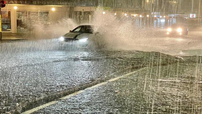
The inner west — specifically flood-prone Marrickville — has copped another downpour tonight with flash flooding across the suburb.
Carrington Rd to Marrickville’s south again is under water after flash flooding less than two weeks ago, with police on site shepherding people around and away from the waters.
Corner Marrickville and Victoria pic.twitter.com/HB017Wrilk
— Scott the Scot (@ScottRhodie) March 7, 2022
Businesses along the road were flooded in the previous deluge on February 22 and will be on alert as the night progresses.
The Bureau of Meteorology has issued a flood alert and warning for the Cooks River with the water level rising and parts of the bank near Tempe station already under water.
According to reports, parts of the Marrickville Golf Club are underwater with the river attempting to swallow up the pavement, while cars have also stalled in flooding on Illawarra Rd.
Cops stopping people from entering pic.twitter.com/6Hv8XezKrP
— Scott the Scot (@ScottRhodie) March 7, 2022
Late on Monday night, the Bureau of Meteorology also issued a severe thunderstorm warning flagging “intense rainfall” around Sutherland, Camden, Campbelltown, Liverpool, Sydney Airport and Sydney Olympic Park.
âš ï¸ Severe Thunderstorm Warning issued for INTENSE RAINFALL around #Sutherland, #Camden, #Campbelltown and #Liverpool. DANGEROUS AND LIFE-THREATENING FLASH FLOODING IS LIKELY. A broader Severe Weather Warning is current for eastern NSW. Updates: https://t.co/Ss766eSCrLpic.twitter.com/0Uoz0tUnrq
— Bureau of Meteorology, New South Wales (@BOM_NSW) March 7, 2022
“Dangerous and life-threatening flash flooding is likely,” the BoM said on social media.
In a more detailed warning, the BoM said there had been 86mm of rain in the two hours to 9.30pm at Lucas Heights.
The BoM also warned of potential major flooding at the Georges River at Liverpool and modearate flooding at Liverpool.
Milperra Public School will not be operational on Tuesday as a result, the school confirmed.
Shocking social media video showed cars floating in flood waters near Bunnings Bankstown Airport on Milperra Rd.
“Very heavy rainfall over the Georges River catchment over the past few hours has the potential to cause major flooding at Liverpool early Tuesday morning,” the BoM said.
“The Georges River at Liverpool Bridge may reach the major flood level of 4.5m around 3:00 am Tuesday and further rises are possible.”
Bowral in the southern highlands has also been cut in half by flash floods which have surged over the bridges and blocked many crucial connective roads across the town.
Many locals found themselves stranded on either the Mittagong or the Burradoo side of Bowral as Mittagong Creek rose suddenly to bisect Merrigang St, Mittagong St, Bowral St, Station St, and Old South Rd.
LATEST ROAD CLOSURE ADVICE
• At Liverpool, the Hume Hwy is closed in both directions due to flooding at the Cumberland Hwy
• At Milperra, Milperra Rd is closed in both directions just east of Henry Lawson Dr, due to flooding at Ashford Av
• At Revesby Heights, Henry Lawson Dr is closed due to flooding at The River Rd
• At Bexley North, Bexley Rd is closed in both directions due to flooding between Slade Rd and the M5 East
• Between Galston and Hornsby Heights, Galston Rd is closed in both directions for repairs due to severe weather
CAMDEN ON HIGH ALERT
MP Peter Sidgreaves urged any residents who live in the affected areas to follow the evacuation order.
He said everyone in the area should stay up to date with the latest information.
“It could be worse than last week, and last week it peaked at about 10.5m,” he said.
“So please follow the advice from the frontline authorities.”
Mr Sidgreaves also asked motorists to be mindful of the conditions, slow down and drive with the lights on.
He said the weather events in the last week have hit local businesses and residents hard.
“It is devastating for the community,” Mr Sidgreaves said.
“It is devastating for the individuals who have had their homes or properties flooded and devastating for the business that have flooded.
“We are looking at providing grants for individuals and I will be recommending they are provided for businesses.”
Mr Sidgreaves urged the community to help out where they could whether that’s by signing up to volunteer for the SES, donating to flood relief or even just offering a friend a safe place to stay for the night.
He added that no one should put themselves at risk by driving through floodwaters or staying in an area that has been ordered to evacuate.
“Follow the experts’ advice,” he said.
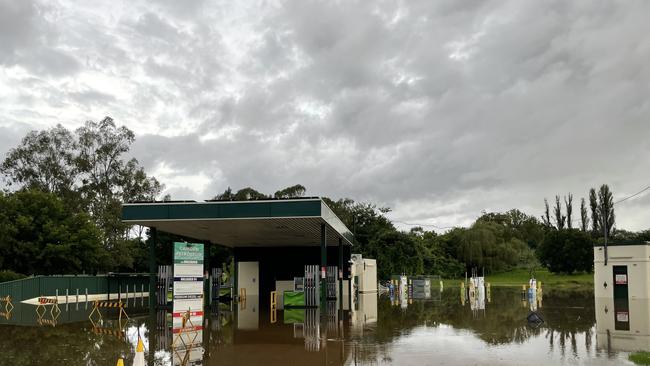
Vishnu Atla has seen his workplace ravaged by floodwaters twice in one week.
Camden Petroleum on Argyle Street flooded last week after intense rainfall hit the region last week causing the river at the Cowpasture Bridge to spill.
Now, the waters are once again rising with the entire grounds of the site under.
“We’ve spent the last four days cleaning everything up to try and get ready to open,” Mr Atla said.
“There was a lot of damage to stock and we had to fix electrical sand fuel pumps.
“Now it’s happening again which makes it hard.”
Mr Atla said he takes comfort in the support of the local community.
“People like coming here because it’s a local business,” he said.
“All the customers are so nice and this entire community is really lovely.”
When the rain was holding off about 6pm on Monday, Camden resident Mart Rampe decided to take advantage and head out on his daily walk.
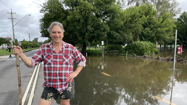
“Look this is a tragic situation but in comparison to other floods it’s not as big,” he said.
“But it’s still awful for the area that’s been affected.”
Mr Rampe said his home was up high and safe from the floodwaters, adding the community has and will continue to rally through the crisis.
“I think that’s the way of most communities in Australia, they get on with the job in due course,” he said.
“I believe people come to the party and help out.
“We are very self reliant, I believe that, and hope we don’t have to wait too much for the government to get their act together.”
Jacki Frost has packed up the car and readied to evacuate for the second time in less than a week.
Last Wednesday a flood evacuation order was issued for Peter Ave, which Ms Frost’s home backs onto.
While the street later evacuated, Ms Frost was on standby.
“It’s a bit like groundhog day because it’s all happening again,” she said.
“Peter Ave has an evacuation warning and while my street doesn’t, I’ll be prepared just in case.
“The water has flooded Belgenny Reserve a lot quicker tonight than last week.”
Even just standing at the reserve, the water levels had already risen in 20 minutes.
Ms Frost said without the rain it was easy to hear the river roaring.
“It makes it a bit hard to relax because you’re wondering where all the water is coming from,” she said.
“We will just wait and see what happens.”
Ms Frost encouraged her fellow community members to stay safe and dry.
“Hang in there,” she said.
“Keep an eye out for everyone.”
EARLIER: ‘Intense’ rainfall on the way for Macarthur region
While the rain has eased off in some parts of the Macarthur region, authorities are warning the worst could be yet to come.
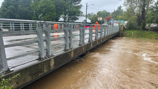
Stonequarry Creek Bridge at Picton has been reopened, but the evacuation warning remains in place for Picton’s CBD as intense rainfalls are expected.
ROAD CLOSURES - See the list here
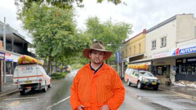
Wollondilly Shire Mayor Matt Gould said there was “considerable concern” for the weather that may hit tonight.
“This new east coast low that is forming up is strengthening and deepening and the latest predictions are could get some very intense rainfall, possibly the worst that we have had through this whole event thus far,” he said.
“Given how wet everything is and how swollen the rivers and creeks already are is a significant concern.”
An Evacuation Order is still in place for Bents Basin Rd, Wallacia. It was issued last week, but remains in place and means residents in the area have to leave.
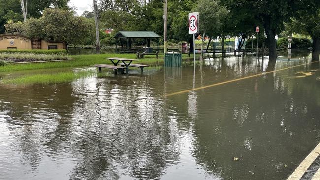
A moderate to major flood warning has been issued for the Hawkesbury Nepean Valley and Colo River at Menangle, Camden, Wallacia, Penrith, North Richmond, Windsor, Sackville, Lower Portland, Wisemans Ferry and Putty Road.
The Nepean River at Menangle Bridge may experience major flooding on Monday night with water levels expected to reach around 14m.
While at Camden Weir the river expected to exceed the moderate flood level of 8.3m around 5pm on Monday. The river level may reach around 9.5m overnight Monday and into Tuesday with moderate flooding.
The Nepean River at Wallacia Weir is expected to exceed the moderate flood level of 8.7m on Monday evening, and may reach the major flood level of 11m by Tuesday morning.
Cr Gould said residents in the shire were tired after nearly a week of “yoyo” weather conditions.
“For the shops on the main street here in Picton, a lot of them have been shut that whole time,” he said.
“That has meant lost trade. They were just starting to get over Covid, so they are having a hard time of it.”
When Stonequarry Creek rises, it brings flashbacks of the horrific 2016 floods, Cr Gould said, leaving many residents on edge.
“They are understandably very concerned about what could happen,” he said.
“For the next 24 hours we are looking at intense rain, so please stay at home unless it’s essential and be prepared to leave.”
Businesses along the main street in Picton have put sandbags in place to help protect the livelihood in case the worst should happen, but on Monday it emerged that many sandbags had been stolen.
“I can’t think of a much lower act than stealing sandbags from shopkeepers that have been closed down for multiple days and going through this nightmare,” Cr Gould said.
“There are plenty of sandbags to go around for free, both at the SES and the RFS.
“There is no excuse and it is such a low act so I hope the people who did this take a really long, hard look at themselves.”
The SES supplied another 100 sandbags so the ones stolen could be replaced.
Cr Gould said the people responsible did not represent the Wollondilly Shire community who had rallied to support each other through trying times.
“We had so many people answering the call to help fill sandbags,” he said.
“People are offering beds, food, shelter. This community is incredible.”
As recovery and clean-up efforts continue in the Macarthur region, more wild weather and flooding is expected over the next few days.
RELATED:
•Southern Highlands prepares for heavy rain, flash flooding
•‘Significant flooding’: Parramatta prepares for another lashing
•‘Emotional wreck’: Gutted mayor returns to flood-ravaged CBD
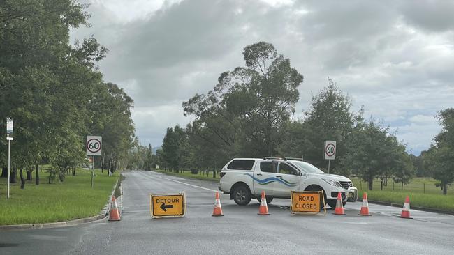
ROAD CLOSURES
Some roads throughout the Macarthur region have been closed due to flooding. Drivers are asked to avoid these roads and find alternate routes.
All roads north of Picton are currently closed, with the only available route into town is by Menangle St, from Picton Rd and the Hume Highway.
Camden Council:
- Anthony Rd, Leppington
- Cawdor Rd/Sheathers Lane, Camden
- Little Sandy Bridge, Camden
- Macquarie Grove Bridge, Kirkham
Wollondilly Shire Council:
- Oberon-Colong Stock Route
- Douglas Park Gorge, Douglas Park
- Broughton Pass, Appin
- Bents Basin Road (Causeway)
- Finns Road and Woodbridge Road (at the Remembrance Driveway roundabout), Menangle
- Werombi Road at Brownlow Hill (from Cobbitty Bridge to Stanhope Road)
- Menangle Bridge, Menangle
- Cawdor Road (from Doncaster Road to Ultimate Paintball)
- Cobbitty Bridge, Cobbitty
- West Parade (Lakes Street Thirlmere to Bargo River Road Railway Crossing)


Join the conversation

Trading places: From a global jetsetter to Macarthur RL’s fastest
The opportunity to play overseas was too good to refuse for one outside back, while another is proving tough to catch in open space. All that and more, Macarthur RL talking points.
Read more

Mexican favourite makes drive-thru debut in southwest Sydney suburb
Popular Mexican chain Guzman y Gomez is opening its second drive-thru location in Macarthur, taking on nearby fast food establishments including McDonald’s, KFC and Oporto.
Read more