
Walk or ride from Beacon Hill to St Ives on a $7m path alongside a historic water pipeline
Authorities are making use of land alongside a 90-year-old Sydney water pipeline for bike riders and walkers on the northern beaches.

Manly
Don't miss out on the headlines from Manly. Followed categories will be added to My News.
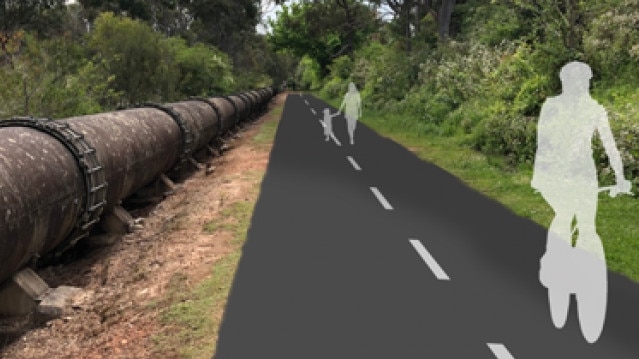
Work has stated on a $7.2 million shared walking and cycling path on the northern beaches that will follow the corridor of a historic above ground Sydney Water pipe.
With the official name — Pipeline Active Transport Corridor — the trail will cut through bushland and reserves stretching more than 9km from Beacon Hill through to St Ives, on the North Shore.
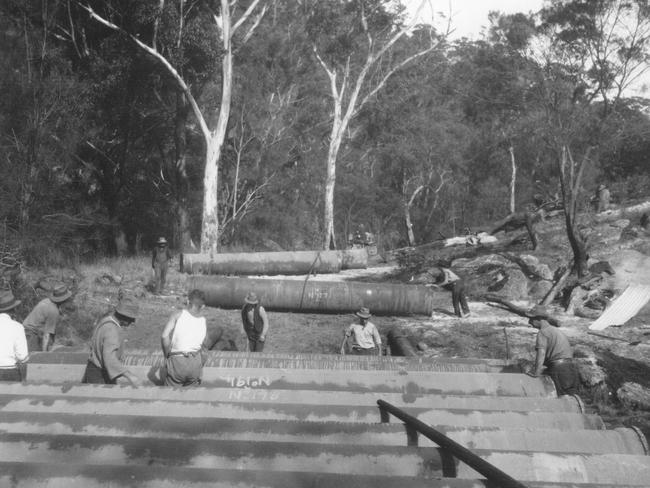
It will follow the corridor created for the Manly Warringah water supply pipeline that opened in 1930.
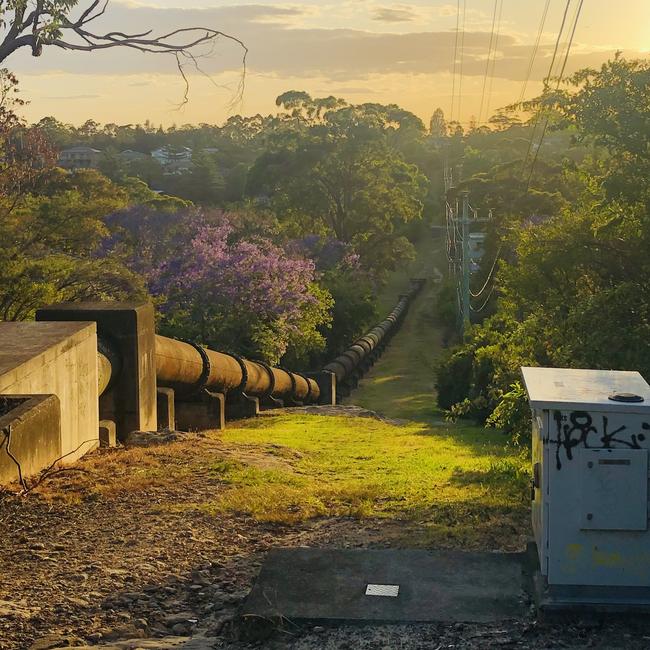
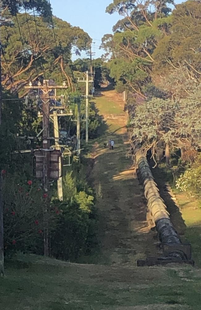
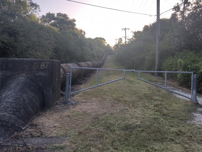
The pipeline, which can be seen in multiple locations at Beacon Hill, Frenchs Forest, Belrose and Davidson, runs from Pymble Reservoir to Dee Why.
To minimise costs, most of the pipeline was laid above ground on concrete saddles on Crown land.
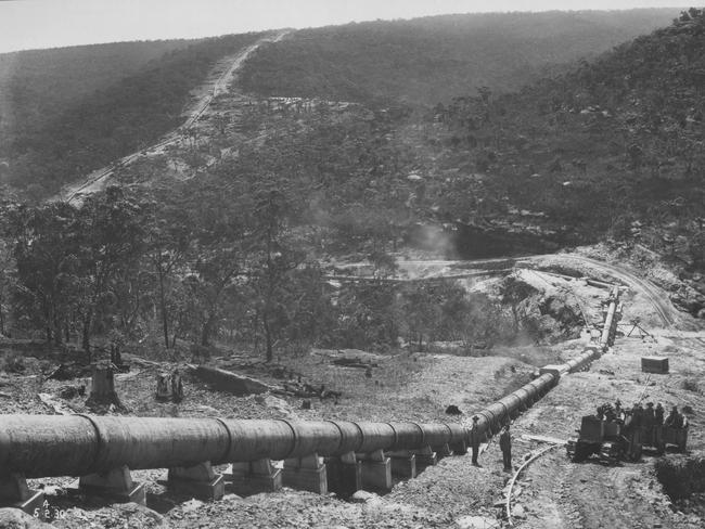
It only plunges underground when it has to go under public roads. The internal diameter of the pipeline is 76.2cm.
Now Northern Beaches Council and Transport for NSW are taking advantage of the land corridor, already popular with walkers, joggers, dog walkers and mountain bikers.
In August 2019, the council voted unanimously to support Liberal councillor Stuart Sprott’s motion to chase grants from the NSW Government, and work closely with Sydney Water, to build a shared path along the pipeline.
Cr Sprott said it could become a “urban trail” connecting Frenchs Forest, the Warringah Aquatic Centre, the new The Forest High School site at Allambie Heights and Beacon Hill.
The council said the trail would provide walkers and cyclists with a wider, safer way to travel between suburbs.
Starting at Ethie Rd, Beacon Hill, the corridor connects the northern beaches with the Ku-ring-gai Council local government area.
Northern Beaches Mayor Michael Regan said it would encourage healthier, more environmentally friendly transport options.
“The active transport corridor will provide wider and safer walking and cycling routes for the growing area of Frenchs Forest and connect the northern beaches to the Ku-ring-gai Council local government area,” he said.
“We know northern beaches residents are seeking more active transport options to beat traffic, maintain healthy, active lifestyles and choose more sustainable transport options.
“Imagine a future where you leave the car at home, avoid parking and congestion, and enjoy a healthier, calmer commute to work or school on foot or bike.”
The project will be completed in eight stages.
Work has already started on “Section six” from Bantry Bay Rd at Frenchs Forest to Warringah Rd, via Rangers Retreat Rd Reserve, and the Sydney Water pipeline. This stage is expected to be complete in early 2023.
The council was also looking into “low-intensity, solar-powered and wildlife-friendly” lighting along the corridor.
The project is proudly funded by the NSW Government Places to Roam – Regional Trails Program to improve active transport on the Northern Beaches. Council will work with Ku-ring-gai Council to complete the works to St Ives.

THE TRAIL – SECTION BY SECTION
Section 1 – Ku-ring-gai
Falls within Garigal National Park and Ku-ring-gai Council area. Currently an unsealed access road accessible by mountain bikes and bush walkers.
Approx length of 2350m from Hunter Ave to Middle Harbour Creek via the pipeline trail.
This is part of shared works between Ku-ring-gai Council and Northern Beaches Council which is currently unfunded.
Section 2 – Middle Harbour Creek Bridge
Creek crossing at Middle Harbour Creek. Currently no access across creek at this location. Bushwalking track to “stepping stone” creek crossing located approx. 800m upstream. Potential for a lightweight bridge to be installed.
Approx length of 40m from Middle Harbour Creek to Middle Harbour Creek via Middle Harbour Creek Bridge.
This is part of shared works between Ku-ring-gai Council and Northern Beaches Council which is currently unfunded.
Section 3 – Davidson Trail
Falls partly in Garigal National Park. Partly sealed with rough asphalt or corrugated concrete with very steep gradients. Popular for bushwalking and used by mountain bikes.
Approx length of 40m from Middle Harbour Creek to Middle Harbour Creek via Middle Harbour Creek Bridge.
This is part of shared works between Ku-ring-gai Council and Northern Beaches Council which is currently unfunded.
Section 4 – Prahan Ave
Section mainly consists of a wide grass access track alongside pipeline. Currently used mainly for recreational walking.
Approx length of 1010m from John Oxley Dr to John Oxley Dr via Prahran Ave.
Section 5 – Frenchs Forest West
Section mainly consists of unsealed or grass access road alongside pipeline. Currently used mainly for recreational walking.
Approx length of 1580m from John Oxley Dr to Warringah Rd using existing unsealed pathway.
Section 6 – Bantry Bay
Part unsealed access track, part sealed access road. Route diverts from Pipeline to allow more direct route to existing Wakehurst Parkway overbridge.
Approx length of 1580m from Bantry Bay Rad, via Rangers Retreat Reserve and pipeline to Warringah Rd.
Section 7 – Manly Dam
Unsealed access track alongside pipeline. This section of track is very popular with mountain bikers and walkers. Corridor forms part of the area’s informal mountain bike network.
Approx length of 1400m from Wakehurst Parkway to Allambie Rd via Manly Dam bike trail.
Section 8 – Allambie Heights
Grass verge alongside pipeline. Generally used by walkers and mountain bikers.
Approx length of 650m from Allambie Rd to Ethie Rd, Beacon Hill via pipeline.


Elderly woman trapped in three-car crash on northern beaches
A woman in her 80s was injured and had to be freed from her vehicle after a three-car collision on one of the northern beaches’ busiest roads.

NSW Premier Cricket: Player T20 rankings 2024/25 season
There was no shortage of fireworks in the recent Kingsgrove Sports T20 Cup. With the shortest format of the Sydney grade cricket season complete, we’ve ranked the stats for each player.