
Satellite imagery indicates WestConnex damage zone is ‘grossly underestimated’
Satellite imaging indicates the so-called 50m “zone of influence” for damage caused by WestConnex construction has been “grossly underestimated”.
Satellite imaging indicates the so-called 50m “zone of influence” for damage caused by WestConnex construction has been “grossly underestimated”.
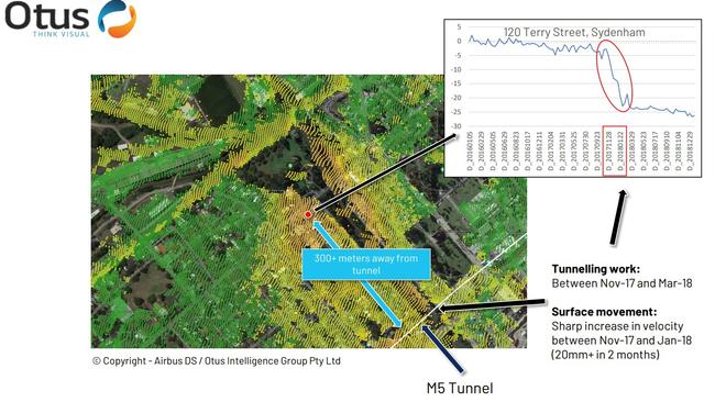
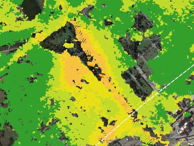
The stark imagery has linked tunnelling with ground movements at sites up to 300m away, including at Sydney Airport’s international terminal and Terry St in St Peters.
The data, provided by Australian “space start-up” Otus Intelligence Group, indicates up to 25,000 residential properties may be impacted by subsidence from the third stage of WestConnex including Carrington St in North Strathfield, land near Bunnings in Ashfield and the Ikea at Tempe.
Coalition Against WestCONnex spokeswoman Rhea Liebmann said the images challenge the State Government’s decision to nominate a 50m “zone of influence” from tunnel edges, which is used as the benchmark of possible property damage.
The cause of damage outside this zone is frequently attributed to dry weather and it is hard for ordinary homeowners to prove otherwise — until now.
Ms Liebmann said the new technology shows the impacted zone had been “grossly underestimated” and opens the door for property owners living further afield to lodge dmanage claims.
“Compensation claims for damage have frequently been denied on the basis they are outside that 50m zone,” she said.
“These satellite images can provide proof that damage has been caused by WestConnex because the imagery predates the start of construction works for the project.”
Crucially, the technology can provide accurate “before and after” photos of subsidence as more 1.5 billion units of measuremen have been captured at 11 day intervals for three years up to January.

WestConnex minister Stuart Ayres assured the project’s contractors would be held accountable for any damage caused to properties.
“RMS has established a review process independent of the contractor,” Mr Ayres said.
“I am waiting to receive the result of that review and I want to assure the community I will move swiftly as soon as I do.
“I want to be very clear — if the contractor has caused the damage they will pay to fix it.”
Otus managing director Mark Beaudry said they planned to provide quarterly updates of the original analysis for phases 3A and 3B of the project as well as other infrastructure projects across Sydney.
“We have been able to go back in time to assess the impact on homes and businesses since work first started,” he said.
Otus is based in the space start-ups program at the Element 8 Incubator & Accelerator at Sydney Olympic Park.
Element 8 Ventures commercial director of innovation Krish Patel said the technology “empowers communities and levels the playing field”.
“Otus is an example of our start-ups playing the agents of innovation, whilst facilitating a new wave of thinking to solve for the future of humanity,” he said.
Otus claims land near Sydney Airport’s international terminal and large gast tanks near Airport Rd had subsided 48mm.
That exceeds the maximum ground movement allowed under the project’s planning approval conditions, which allows 30mm for ordinary properties, 20mm for heritage and sensitive properties and 40mm for roads and parking lots.
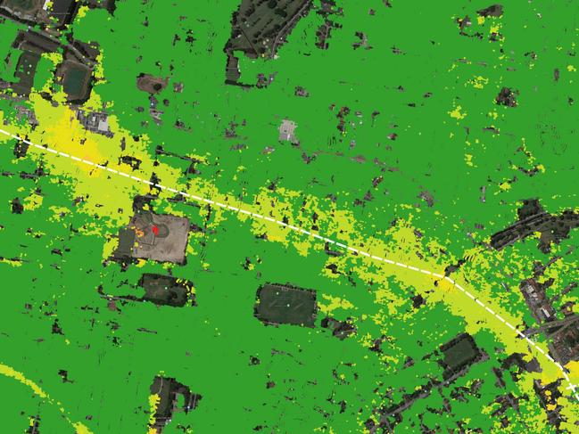
The imagery revealed more than 80mm of movement at Ikea in Tempe, more than 100mm at a Sydney Airport carpark, 18mm near Bunnings Ashfield, 15-20mm at Carrington St in North Strathfield and 18-20mm on Concord Rd.
The Environmental Impact Statement for the project states ground movements of between 1-10mm “are usual and to be expected” while the maximum expected subsidence was supposed to be 5-10mm.
IN OTHER NEWS
Leichhardt Against WestConnex (LAW) has been working with Otus and Element to ensure the information gets out to the public and has called on the government to make the technology available to all residents living on the route for free.
Balmain Greens MP Jamie Parker said the data demonstrated the State Government had “failed to protect residents and has not been honest”.
“This data has been timelined against tunnelling activity to firmly establish causation between the tunnelling and ground movement,” Mr Parker said.
An RMS spokesman said satellite technology can be a valuable tool to help assess ground movement over time.
“We are currently considering a range of providers who offer this satellite service,” he said.
“The service will be procured in line with Government requirements, ensuring there is no conflict of interest and the best value for money is secured.
“If appropriate we will use satellite data to assist the independent Property Impact Assessment Panel in their review of property damage claims.”

Alleged underworld killer to stand trial over ‘brazen’ shooting
An alleged underworld assassin and brothel manager will stand trial over the shooting death of a sex worker’s husband, who allegedly accused him of sleeping with his wife.

Best of the best! Top 29 Aussie schools rugby sevens girls
They have speed, physical presence, silky skills and that special X factor. Australia’s top schoolgirl sevens players have been identified and the talent is extraordinary. TOP GUNS list