
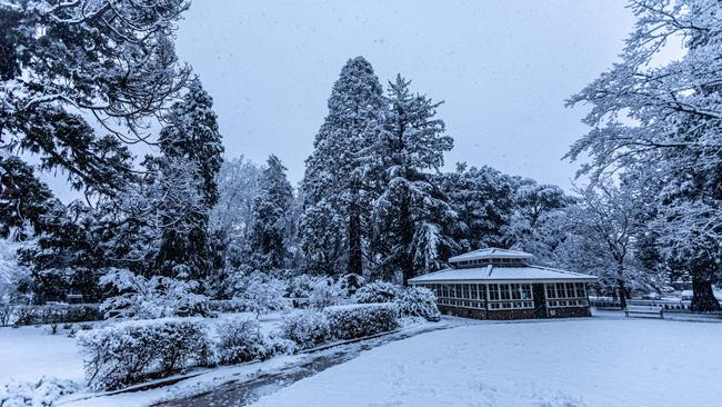
Where to see snowfalls in Canberra and Southeast NSW
After a wet and wild summer, the colder weather has heralded the season’s first forecast snowfalls, with areas of southeast NSW, Canberra, and the Central Tablelands set for a dusting.
Canberra Star
Don't miss out on the headlines from Canberra Star. Followed categories will be added to My News.
With the mercury set to dip below zero across large swathes of Southeast NSW and the Canberra region, meteorologists are forecasting for households across the state to see their first snowfall of the year.
From Orange to Canberra and the Perisher Valley, the Bureau of Meteorology has predicted light dustings of snow as a seasonal cold snap heralds the end of a wet and wild summer.
From Monday, the temperature will plummet to zero and below across the Alpine regions, according to Bureau of Meteorology meteorologist Helen Reid, as well as the ACT’s Brindabella ranges.
Ms Reid said that the “usual suspects” can expect snow on Monday, including Corin Forest in Canberra, with cold weather spreading further north through Tuesday and Wednesday.
“We’ll see some snow during the course of the day in the Alpine regions, and the Brindabellas,” she said.
“As we head into tomorrow, it will be quite widespread. We could expect a little snow creeping over the ranges, really west of the ranges and to the southwest.
“And, we’re expecting to see a little as far north as the central tablelands as well.”
Forecast temperatures across the region are set to fall as the week progresses, increasing the likelihood of snow, Ms Reid said. The Alpine and Brindabella regions will dip below zero in coming days.
In the Central Tablelands, meanwhile, the mercury will reach three to four degrees before falling to only one degree by Wednesday, Ms Reid said. Orange will maintain temperatures of around four degrees.
The cooler weather comes less than a year after parts of the Tablelands received a heaping of snow, including in Orange. In June 2021, the town was blanketed in snow, its biggest dumping in years.
Goulburn and parts of the Blue Mountains also received snow in 2021, with a blanketing that covered the popular hiking destination of Katoomba.
In 2015, residents of the NSW Southern Highlands were greeted with surprising snowfalls.
Areas near Bowral, Colo Vale, and Mittagong were hit with heavy snows, closing schools and highways.
While this year’s cold snap is good news for skiers, it doesn’t mean the snowfields are fully operational.
Despite receiving light dustings earlier in the year, Ms Reid said it’s not time to bust out the skis and tyre chains just yet.
“We’re expecting those ski fields to get a little white covering, but not ski-worthy yet,” she said.
“But, maybe a nice precursor for the season.”
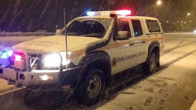
Meanwhile, the bureau has also warned of heavy winds to lash the state on Monday.
According to a statement, damaging gusts averaging 70km with peak gusts in excess of 90km are likely over the far west of NSW this morning, reaching the Great Dividing Range by this afternoon and the east coast this evening.
âš ï¸Severe Weather Warning ongoing for #NSWweather. Damaging winds expected in the west of the state this morning, extending to the coast by this evening. Full details https://t.co/Ss766eSCrLpic.twitter.com/MtWeC84BuV
— Bureau of Meteorology, New South Wales (@BOM_NSW) May 29, 2022
“Saturated soils bring an increased risk of gusty winds toppling trees and powerlines, particularly along elevated terrain,” the bureau said.
“Locations which may be affected include Sydney, Wollongong, Nowra, Batemans Bay, Armidale, Orange, Canberra, Goulburn, Dubbo, Wagga Wagga, and Albury.”


Big boppers, livewire: Unusual mix of U15s City v Country players to watch
There’s a mix of tall timber, an amazing smaller player, big boppers and a livewire hooker. It’s why the City v County U15s battle at Newcastle is shaping up to be a memorable one.

Canberra sale and auction results, week ending July 26
Canberra recorded 11 property sales over a million dollars last week, the latest auction and sales results reveal.