
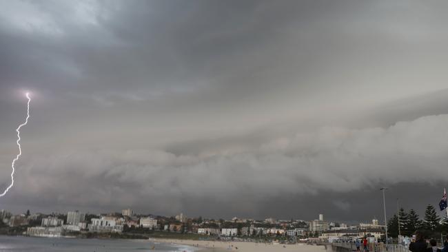
Sydney to be lashed with wild weather
Batten down the hatches Sydney — a “hectic” storm set to smash the state could cause flash flooding in the city on Wednesday.
Batten down the hatches Sydney — a “hectic” storm set to smash the state could cause flash flooding in the city on Wednesday.
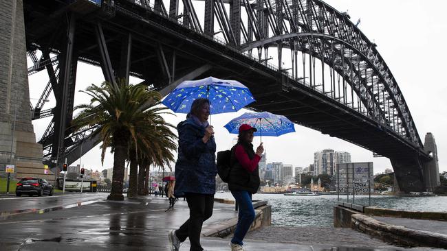
The Bureau of Meteorology has issued a flood watch and severe weather warning as a big cold front bears down on coastal areas from the west bringing with it heavy falls and strong winds.
Sydney could receive up to 100mm of rain in “wet and wild” conditions from Wednesday morning onwards, duty forecaster Anita Pyne warned.
“It’s going to be wet for everyone,” she said.
“The heavy rainfall will be localised. If it’s in low-lying areas and they get a big dump or in some of the rivers it could lead to flash flooding.
BASSAM HAMZY SPECIAL REPORT:
Part 1: Hamzy to mum: ‘Did you send me some undies?’
Part 2: What Hamzy’s handwriting says about him
Part 3: How Bassam Hamzy plotted bloodshed from prison cell 214
Transcripts: ‘I want you to go and kick the f**k out of him
How Hamzy began two-decade reign of terror
Night Hamzy’s blood reign over Sydney began
“With this big winds will whip up hazardous surf conditions. It’s going to be pretty hectic.”
Ms Pyne said the heaviest falls would likely be over the Sydney and Illawarra regions, but the northern part of the South Coast, Central Coast and Blue Mountains could also be smashed.
NSW SES spokesman Phil Campbell said crews were expecting flash flooding in Sydney’s metropolitan area.
“It will cause a number of issues, there will be flash flooding and that will be a concern for us because we will have people driving into flood waters either by accident or design,” he said.
“We’re expecting a significant number of flood rescues.”
Mr Campbell said rivers could swell in western Sydney and present further danger on Thursday.
“We’re also going to have riverine flooding,” he said.
“Low-lying bridges (across western Sydney) and the Sackville and Wisemans ferries — those could potentially be affected on Thursday.”
Sydney waterways that could be affected include the Parramatta, Nepean, Hawkesbury, Georges and Woronora rivers.
Gale warnings have also been issued for the city’s closed and coastal waters.
The majority of the storm will be over in a six to 12-hour period before it moves offshore and conditions begin to clear on Wednesday night.
Sydney and the Illawarra are predicted to receive up to 100 millimetres of rain but localised totals in the “bulls eye” of the storm could exceed 200mm, Ms Pyne said.
Ms Pyne urged motorists to avoid driving into floodwaters.
“If it’s flooded – forget it,” she said.
“In terms of flash flooding, that really depends on where the bulls eye of this system hits.
“The big falls will be associated with the centre of this system. Our models are painting a few different scenarios, but they’re all around the Sydney and Illawarra regions.”
Download The Daily Telegraph and Sunday Telegraph app for your smartphone or tablet to get the full story.
APPLE: DOWNLOAD THE APP FOR iOS
GOOGLE PLAY: DOWNLOAD THE APP FOR ANDROID

WHAT YOU GET WITH OUR APP
► Live and latest news — Get the news as it breaks 24-hours a day, 7 days a week
► My News — Your own personal news feed. Tailor your news to get straight to the topics that matter to you
► Today’s Paper — Read the paper anytime, anywhere with the digital replica of the paper, as its printed
► Notifications — Be the first to know when big stories break with instant news alerts straight to the locked screen on your smartphone and tablet
► Live Sport Scores — Stay on the ball with NRL and AFL live sport scores and expect analysis
► Share — Join the conversation and share your favourite stories via Facebook, Twitter or email
► Daily puzzles — With new crosswords and Sudoku puzzles every day, there’s always something to keep your mind active
► Subscribe — Through the app (via iTunes) to start your 30-day FREE trial; then your subscription will automatically renew to $29.99 per month.

Invitation only: Minns among the high-flyers
The latest ministerial disclosures revealed Premier Chris Minns to be the only pollie to receive an invite to Beyond, Virgin Australia’s invitation-only airline lounge.

How Julia Zemiro upgraded in the Southern Highlands
Popular comedian, actor and TV presenter Julia Zemiro and her partner, real estate agent Carsten Prien, have found a buyer for their Bowral home as they upgrade in the Southern Highlands.