
"Benign" weather for North Coast while Qld braces for cyclone
Light showers and cloudy forecast for the weekend on the North Coast while Queensland braces for category five Cyclone Debbie to hit.
Lismore
Don't miss out on the headlines from Lismore. Followed categories will be added to My News.
LIGHT showers and cloudy days are forecast for the weekend on the NSW North Coast, while Queensland braces itself for a category five cyclone to hit on Monday or Tuesday.
A Weatherzone forecaster said the Northern Rivers can expect "benign" weather conditions along the coast and hinterland this weekend, with sporadic showers and increasing temperatures on Sunday.
"It will be fairly cloudy today and tomorrow, with warmer temperatures expected tomorrow," he said.
"Showers will be light and isolated."
- Lismore: 27 today, 30 tomorrow
- Byon Bay: 25 today, 28 tomorrow
- Ballina: 27 today, 29 tomorrow
- Kyolge: 28 today, 31 tomorrow
- Murwillumbah: 27 today, 30 tomorrow
- Tweed Heads: 27 today, 28 tomorrow
#CycloneWatch continues #CapeTribulation to #StLawrence. High chance of #Cyclone formation today. Latest info at https://t.co/YTkwbdYNGp pic.twitter.com/WfudXoDpVj
— BOM Queensland (@BOM_Qld) March 24, 2017
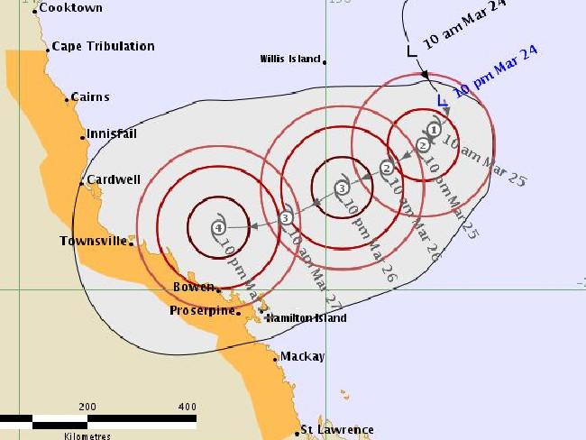
Meanwhile, the Bureau of Meteorology has issued a tropical cyclone warning stretching from Cape Tribulation to St Lawrence, in Queensland, with a cyclone expected to make landfall in the next several days.
If it lands, it will be called Cyclone Debbie and will be the first tropical cyclone to make landfall on the Qld coast in two years.
The cyclone could intensify to category five by the time it crosses the coast somewhere between Cardwell and Bowen, near Townsville.
"It's likely to slowly make it's way into between Bowen and Cardwelll, later on Monday or on Tuesday," a Weatherzone spokesman said.
"That system has a high risk to become a severe tropical cyclone.
"At the moments it's forecast to become a category five, before making landfall.
"There is a risk of gales between from Cape Tribulation to St Lawrence in the next 24 - 48 hours.".
BOM Queensland Regional Director, Bruce Gunn, said the low was located approximately 600km northeast of Cairns and Townsville, and likely reach cyclone strength as early as Saturday.
"Communities between Cape Tribulation and Proserpine are urged to prepare now for a potential crossing anytime between late Sunday and early Tuesday, but the most likely scenario is for the cyclone to make landfall between Cairns and Townsville on Monday," Mr Gunn said.
"There is always a degree of uncertainty in forecasting cyclones, for this reason we urge the public to stay tuned for the latest official warnings from the Bureau of Meteorology and follow the advice of local emergency services.
"The intensity of the cyclone will hinge on how much time the system spends over the water. If the cyclone speeds up, it is likely remain at the lower end of the spectrum, but if it crosses on Monday or Tuesday there is the potential for it to intensify to severe tropical cyclone strength, Category 3 or higher."
MEDIA RELEASE: #CoralSea Tropical #Cyclone likely to develop this weekend, read more: https://t.co/NnPllYOZN1 pic.twitter.com/myjaL7z5zY
— BOM Queensland (@BOM_Qld) March 24, 2017

‘Maintaining the integrity’: NRRRL makes call on catch-up games
After wet weather derailed the early part of the season, the NRRRL has made a decision on the outstanding catch-up rounds.

Curfew for man on long list of car theft, break and enter charges
In a Mid-North Coast town beset by youth crime, one offender has fronted court to plead guilty to firearms and break and enter charges.