
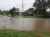
Glenreagh flooding worsens as Bluff Bridge photos shows rapid rise
Incredible before and after interactive shows extent of flooding around Glenreagh.
Coffs Harbour
Don't miss out on the headlines from Coffs Harbour. Followed categories will be added to My News.
The Orara River reached heights of more than 10 metres yesterday as the constant deluge cut roads and inundated properties yet again.
The new automatic flood camera near Glenreagh captured the impact perfectly, with the Bluff Bridge crossing going from almost passable to a torrent of fast flowing water in a matter of hours.
The region has been battered by torrential rain for days, with authorities warning people to stay vigilant and stay off the roads where possible.
About 3pm Monday the Orara River was peaked at the Glenreagh automatic gauge at more than 10.6 metres, when just 24 hours before it had been at 4.48.
As of 11am this morning it was at 9.14m, still exceeding the moderate flood level of 9m.
While it is the highest level reached in years, it fell short of 2012 levels which hit the 11.44 metre mark.
The highest recorded flood in Glenreagh was in 1974 when the Orara River rose to more than 13 metres.
Residents in Glenreagh have recently raised questions over the recently installed flood monitoring system, which triggers an automatic sign on either side of the notorious Bluff Bridge river crossing.
They say the signs are unreadable even on a overcast day and have resorted to putting out their old signs alerting drivers to the closed road which is the alternative route north to Grafton.
Originally published as Orara River flooding worsens as photos show rapid rise

Coffs Harbour sale and auction results, week ending June 21
Coffs Harbour proved to be a hot market last week with seven properties selling for a total value of $5.6 million. See the latest auction and sales results.

Blood stains link in Ballina murder trial
Multiple blood stains found on a variety of items in a laneway behind an op-shop where 64-year-old Lindy Lucena was found dead have been linked to her accused killer, a trial has heard.