Widespread thunderstorms approach as temperatures spike
A severe thunderstorm warning for heavy rainfall and damaging winds has been issued for western and central Queensland, with Brisbane temperatures set to reach 35C later in the week.

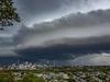
A severe thunderstorm warning for heavy rainfall and damaging winds has been issued for western, central and southern Queensland.
At 4.09pm, the Bureau Of Meteorology said severe thunderstorms were occurring in parts of the North West, Central West and parts of Gulf Country, North Tropical Coast and Tablelands, Northern Goldfields and Upper Flinders, Herbert and Lower Burdekin, Central Highlands and Coalfields, Channel Country, Maranoa and Warrego and Darling Downs and Granite Belt forecast districts.
Locations which may be affected include Longreach, Winton, Mount Isa, Cloncurry, Goondiwindi and Julia Creek.
Bureau of Meteorology forecaster Brooke Pagel said their main concerns are for heavy rainfall with potential flash flooding around south east Queensland stretching out west to Charleville.
“Heavy winds could also be seen from the Charleville and Roma area up to Longreach,” Ms Pagel said.
Ms Pagel described the storm movement as a “longer horseshoe trough” starting from Mount Isa and the Gulf Country, stretching right through to the Gold Coast and parts of Brisbane.
“The storms are quite widespread due to the trough and where it sits at the moment,” Ms Pagel said.
Ms Pagel said on average for South East Queensland we should expect about 25mm of rain today and could see higher numbers tomorrow.
According to Ms Pagel from today through to Thursday in Brisbane we have a maximum of 32 degrees reaching 35 degrees on Thursday and Friday.
Ms Pagel said our humidity levels are also well above average for this time of year.
Humidity levels in southern parts of South East Queensland including Gatton, Amberley, Beaudesert and Redlands will reach dew temperatures of 22 today with similar levels tomorrow.
“When it comes to dew temperatures, anything over 16 to 17 is pretty sweaty,” Ms Pagel said.
“The humidity has come on quite suddenly, but it should blow over quickly,” Ms Pagel said.
Ms Pagel said the South-East interior has extreme fire danger warnings, particularly the Darling Downs area and Granite Belt district from Wednesday.
Sky News meteorologist Rob Sharpe confirmed the wild weather was being driven by a low-intensity heatwave sitting across NSW and the Brisbane region, which would transform into “severe thunderstorms right up and down that eastern coastline” midweek.
Mr Sharpe said Queensland should brace for a “long, wet run”, with the next fortnight looking “wetter than usual” across the whole state. Eight-day rainfall totals of more than 50mm are expected along the coast.