Wet conditions follow day of record-high humidity
Southeast Queenslanders woke to another morning of stifling humidity after record-high levels yesterday. But there is an end in sight.

Cooler conditions have helped ease stifling humidity in Southeast Queensland after record-high levels on Saturday.
Relative humidity was sitting at 93 per cent at 7am Sunday, according to the Bureau of Meteorology, but this had dropped to 83 per cent in Brisbane by 10am and further again to 76 per cent by 11.20am. Parts of the Gold Coast had dipped to 79 per cent by 10am and further again to 74 per cent by 11.20am. Parts of the Sunshine Coast were still sitting at 99 per cent at 9am.
The southeast experienced a wet start to the day with a band of showers sitting over the southeast for several hours. The showers had largely moved offshore by 10am but more potential showers were expected later in the day.
Meteorologist Angus Hines said the dew point, which was already at an oppressive 22.4C by 8am, could rise even further throughout the day.
“Unfortunately there’s not a massive decrease in the humidity ... so generally another pretty sticky day,” Mr Hines said.
“We saw a very sticky day yesterday with a dew point of up to 24 degrees for most of the afternoon.
“There is some cloud coverage at the moment, that cloud coverage should break apart and let the sun through but unfortunately that humidity will stay fairly high.”
At 7.40am Sunday the temperature was already at 23.6C but felt like 27.8C with a dew point of 22.4C.
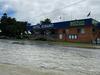
It comes after a series of showers across Friday and Saturday.
The Bureau has forecasted rainfall to be anywhere between 0 and 20mm of rain on Sunday, but Mr Hines said the storm risk had diminished for Brisbane.
“There are a few showers definitely on the menu ... and those will bring a few millimetres of rain but none of that heavy rainfall that has caused flooding over the past couple of weeks,” Mr Hines said.
The southeast can expect drier conditions from Monday when the forecast is for a possible shower for Brisbane, before a mostly sunny day on Tuesday and dry conditions for the rest of the week. The Gold Coast is expecting a mostly sunny day on Monday onwards while the Sunshine Coast is expecting a shower or two clearing Monday, a shower or two Tuesday and Wednesday and then dry conditions from Thursday.
Meanwhile, across Queensland, Mr Hines said the bureau was watching Wide Bay and Capricornia coasts closely.
“There is some heavy rain offshore near the coast ... (with a) possibility of 50 to 100mm if that rain does move onshore,” Mr Hines said Sunday morning.
“There is an increasing likelihood that the worst of the weather will stay out over the ocean and stay away from Queensland.
“Much of the state today is anticipating a little bit of a brighter day, a little bit of a drier day but it is not going to be completely dry for everyone.”
Mr Hines said flood warnings remain in place across Queensland after a series of thunderstorms over the past couple of weeks.
“There are several flood warnings around the North Tropical Coast and a little bit down south as well due to that heavy rainfall from (Friday),” Mr Hines said.
“There’s moderate flooding in the Tully River, the Murray River and the Haughton River.
“Now the river there rose quickly and that heavy rain came through to start the weekend. But (those rivers) do tend to also drain reasonably quickly. It’s not unusual to get really heavy rain in that part of the country.
“There’s still an extensive network of flood warnings through our central and western parts of the state...
“It takes a long time for flood waters to move through some of those rivers. So there are still some major flood warnings active around the Gulf of Carpentaria.
“They have been there for several weeks now ever since that heavy rain came and due to tropical cyclone Kirrilly a few weeks back.”

Current food warnings since 5.10am Sunday 25 February:
• Major Flood Warning for the Flinders River
• Major Flood Warning for the Nicholson River
• Moderate Flood Warning for Eyre Creek and Minor Flood Warning for the Georgina River
• Moderate Flood Warning for the Diamantina River
• Moderate Flood Warning for the Haughton River
• Moderate Flood Warning for the Tully and Murray Rivers
• Minor Flood Warning for the Bulloo River
• Minor Flood Warning for the Herbert River
• Minor Flood Warning for the lower Barcoo River and Cooper Creek
• Minor Flood Warning for the Norman River and Flood Warning for the Gilbert River
• Minor Flood Warning for the Paroo River (QLD)