
Queensland weather: More storms forecast after record breaking humidity in state’s southeast
Widespread rainfall and patchy thunderstorms continued overnight following one of South East Qld’s most humid days on record.
QLD weather news
Don't miss out on the headlines from QLD weather news. Followed categories will be added to My News.
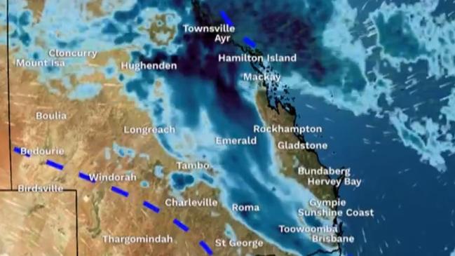
Record-high levels of humidity across South East Queensland Saturday morning gave way to severe thunderstorms with heavy rainfall across southern and central Queensland.
A series of severe thunderstorm warnings issued for the Wide Bay, Burnett, Gympie and Southeast Coast forecast districts were cancelled by late Saturday but the threat remained in areas from Monto to Tiaro.
The Bureau said heavy rainfall in these areas may also lead to flash floods overnight on Saturday.
It comes after a morning of oppressive humidity on Saturday. At 11.20am, it was 30.3C in Brisbane but felt like 36.2C due to an oppressive dew point of 25C.
The Bureau of Meteorology’s Steve Hadley said it was one of the most humid days they had seen.
The high humidity is being caused by an upper level low and trough sitting across the southern parts of the state as well as a build up of a tropical air mass.
Mr Hadley south south-westerly winds saw temperatures drop on Saturday afternoon.
“This combination has provided some scope for there to be heavy rainfall and thunderstorms over the next few days in the southeast,” he said.
Residents in the Scenic Rim, Lockyer Valley and Somerset regions have also been urged to stay across warnings across the weekend as storms move north from New South Wales.
“There is a risk of intense rainfall which could lead to flash flooding in these areas as well,” Mr Hadley said.
BOM Meteorologist, Shane Kennedy, suggested that Saturday’s heavy cloud cover and patchy rainfall have kept temperatures low and “greatly reduced” the number of thunderstorms expected to move through south east Queensland in the afternoon.
He said that there are some storms much further inland, around Goondiwindi, and south of the NSW border.
While they are expected to be “very isolated” and less wild than previously thought, Kennedy said that storms will likely continue into Sunday.
“A southerly wind change will push through overnight and that may trigger some storms from (Saturday) evening,” he said.
⛈ï¸Saturday forecast: severe thunderstorms with heavy rainfall are possible in north and far north Queensland and in the southeast east of Goondiwindi to Biloela, especially over the southern Darling Downs, Scenic Rim, and Lockyer Valley. Warnings: https://t.co/uckiM9YDYepic.twitter.com/Nni13igk3P
— Bureau of Meteorology, Queensland (@BOM_Qld) February 24, 2024
The storms should clear up by Sunday afternoon, Mr Kennedy said.
He suggested that the start of next week will see more moderate temperatures than this week and a fairly consistent 30-40 per cent chance of light showers, but that no thunderstorms are forecast.
The Bureau on Friday said they weren’t ruling out the possibly of “intense rainfall, damaging winds and golf ball-sized hail”.
Meanwhile 280m of rain fell in just six hours at Tully in Far North Queensland, with severe storm warnings still active for people in parts of the North Tropical Coast and Tablelands forecast district.
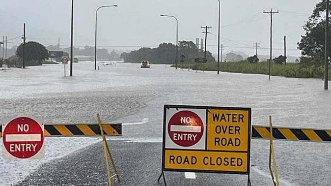
In the past 24 hours, totals of up to 400mm have been recorded in areas surrounding Tully, including 360mm at Mission Beach.
“There’s been some six hourly totals that are quite high upwards of 200mm in six hours and that’s meant rivers and creeks have risen rapidly,” Mr Hadley said.
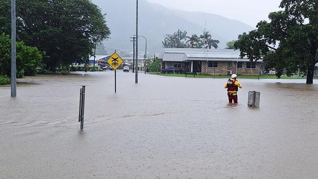
Swift water rescue crews rescued three people from a train stranded in floodwaters adjacent to the Bruce Highway outside Tully.
Mr Hadley said a flood warning had been issued for Tully.
“Boulden Creek received about 270mm in six hours,” he said.
The Bureau of Meteorology warns that “severe thunderstorms are likely to produce heavy rainfall that may lead to flash flooding in the warning area over the next several hours.
“A weak trough just inland from the coast and very moist onshore flow are likely to lead to slow-moving clusters of heavy showers and a few thunderstorms capable of producing heavy rainfall.
“The system is slowing moving offshore this morning”
Latest temperature forecasts
Brisbane:
Sat: Minimum: 24C, Maximum: 31C
Sun: Min: 23C, Max: 28C
Mon: Min: 22C, Max: 31C
Tues: Min: 22C, Max: 31C
Gold Coast:
Sat: Min: 25C, Max: 30C
Sun: Min: 23C, Max: 27C
Mon: Min: 23C, Max: 29C
Tues: Min: 22C, Max: 29C
Sunshine Coast:
Sat: Min: 23C, Max: 31C
Sun: Min: 23C, Max: 27C
Mon: Min: 22C, Max: 29C
Tues: Min: 22C, Max: 29C

Join the conversation

Ice ice baby: Spectacular images of unseasonal frost as Qld freezes
Queensland’s overnight temperatures will increase to double digits in the coming days, following the coldest start to winter in 16 years, bringing frost and ice to many regions. SEE THE PHOTOS
Read more

City’s coldest June start in 16 years, feels like MINUS 9.8C out west
Southeast Queensland is shivering through its coldest morning in more than 15 years but feels-like temperatures have dropped to insane levels in the southern inland.
Read more