
The great Brisbane storm dome explained
The great Brisbane storm dome debate has ignited again after yesterday’s storm front split over the city.


QLD weather news
Don't miss out on the headlines from QLD weather news. Followed categories will be added to My News.
Meteorologists have weighed in on the great Brisbane storm dome debate after a large storm front split in two over the city on Wednesday.
Trees were knocked over, power poles snapped and torrential rain fell as the storm barrelled across the Darling Downs and Lockyer Valley towards Brisbane.
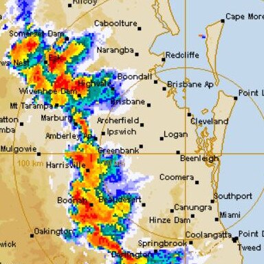
But as it reached the western outskirts of the city, like it has many times before, the storm split in two.
While photos and video show large hail, extensive damage and flash flooding to the city’s north and south, only 3mm of rain fell in Brisbane.
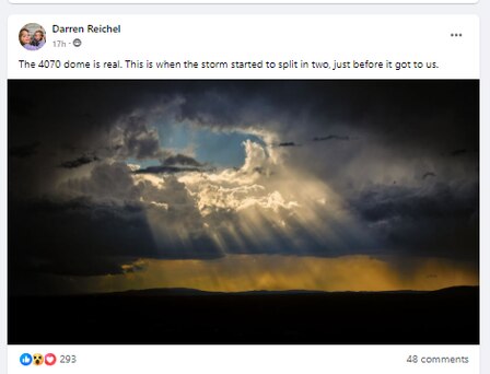
The reaction – and references to the great Brisbane storm dome – were almost instant on social media, with one commenter likening it to the “parting of the Red Sea”.
“ … the storm front has split in two and gone around us!” they said.
“Absolutely zip in bayside! The dome must have been active again, like not even one drop,” someone else commented on Facebook.
Is the Brisbane storm dome a real phenomenon?
Bureau of Meteorology senior meteorologist Kimba Wong said Brisbane sat within a valley along the river path which often allowed it to miss out on the thunderstorms.
“It does sit within a low point which can make it a little less likely to receive rain when either side might get more.”
Ms Wong said the sporadic rainfall demonstrated just how “hit and miss” storms can be.
“It’s a good thing that Brisbane mostly dodged a bullet with the damaging weather,” she said.
“Sometimes storms just have that ability to forge their own path and that’s clearly what has happened here,” she said.
What causes storms to split in two?
Sky News meteorologist Alison Osborn said the westerly winds pushed the storms in separate directions.
“As much as we can predict when the storm will form, where they develop on any given day can have an element of surprise to it,” she said.
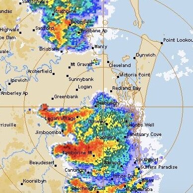
Ms Osborn said the winds allowed the storms to move north and south of Brisbane particularly in Caboolture and over the Scenic Rim.
“The hinterland regions obviously get a lot as well but the idea of storms continuing to travel away from Brisbane is not a common theme,” she said.
How long has the Brisbane storm dome been a thing?
Early Warning Network meteorologist Ken Kato said the “dome effect” over Brisbane has happened on occasion.
“But whether that’s a pattern is hard to say,” he said.
Mr Kato said a contributing factor could be Brisbane’s land use.
“Lots of urban development can mean the air has slightly less moisture in it which is common in built up areas,” he said.
“When there’s less air moisture being sucked into the storm that can weaken it significantly which could’ve caused the split but whether that’s a pattern is hard to tell.
“If you look at the weather radar when there’s storms around they can be stronger over higher ground like the scenic rim but Brisbane sits in a lower valley.”

Ice ice baby: Spectacular images of unseasonal frost as Qld freezes
Queensland’s overnight temperatures will increase to double digits in the coming days, following the coldest start to winter in 16 years, bringing frost and ice to many regions. SEE THE PHOTOS

City’s coldest June start in 16 years, feels like MINUS 9.8C out west
Southeast Queensland is shivering through its coldest morning in more than 15 years but feels-like temperatures have dropped to insane levels in the southern inland.