
Queensland weather: Severe thunderstorms possible today after large hail, destructive winds cut power to thousands
A tropical cyclone is likely to form in the Coral Sea over coming days – though direct impacts on Queensland are unlikely – following days of wild storms.


Giant hail and destructive winds are again possible today after supercell storms caused widespread damage and left thousands without power on Friday.
Meanwhile, a possible cyclone is set to form off the Queensland coast in coming days.
The Bureau of Meteorology is forecasting severe thunderstorms for the Wide Bay, northern Darling Downs and southern Capricornia regions this afternoon.
“There are potential wind gusts of up to 90km/h linked to those storm cells moving through the Sunshine Coast and Central Highlands,” meteorologist Patch Clapp said.

“This activity is caused by a moist and unstable air mass sitting over Queensland.”
The Bureau of Meteorology has warned a tropical cyclone could form over the weekend before making its way towards the Australian far northeast coast but won’t make direct impact.

The alert was issued on Friday and forecasted a high chance of a tropical cyclone developing near the Solomon Islands or far northeast of the Coral Sea next week.
“This weekend a tropical low, 02U, is likely to form within Fiji’s area of responsibility,” the BOM said.
The system is likely to move into the Australian area of responsibility in the Solomon Sea either on Monday or Tuesday, before turning towards the south or southwest.
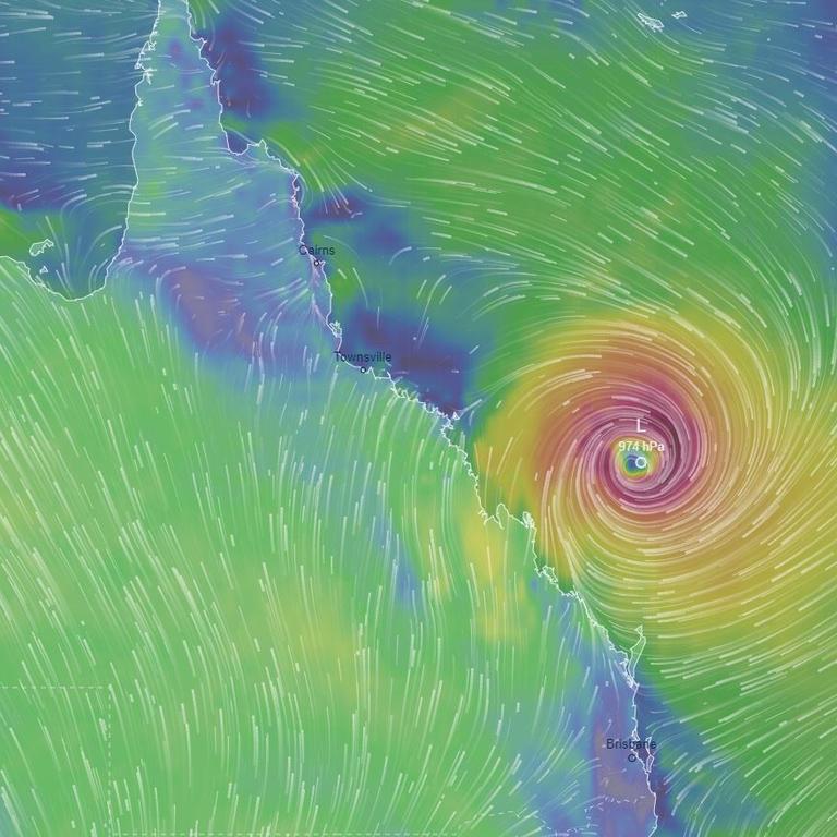
“02U has a moderate chance of developing into a tropical cyclone from late Monday, and a high chance from late Wednesday,” the bureau said. “02U is forecast to remain a long way from the Queensland coast and no direct impacts are expected.”
The BOM said it could move into the far northeast Coral Sea either on Wednesday or Thursday.
Golf-ball sized hail and wind gusts to 100km/h were recorded across the Darling Downs on Friday with more than 10,681 Energex customers left without power, 4000 of which are on the Sunshine Coast.
“For the southeast Archerfield recorded winds of 83km/h while Brisbane Airport had about 70km/h,” Mr Clapp said.
The highest rainfall totals during the storms were 57mm at Gayndah, 50mm at Dalby and 35mm at Roma, while 20mm fell in Brisbane.

Temperatures are expected to remain above average across the weekend, with Brisbane to get to 33C today and tomorrow.
The hottest places in Queensland are expected to be Longreach at 40C and Mt Isa at 39C.

