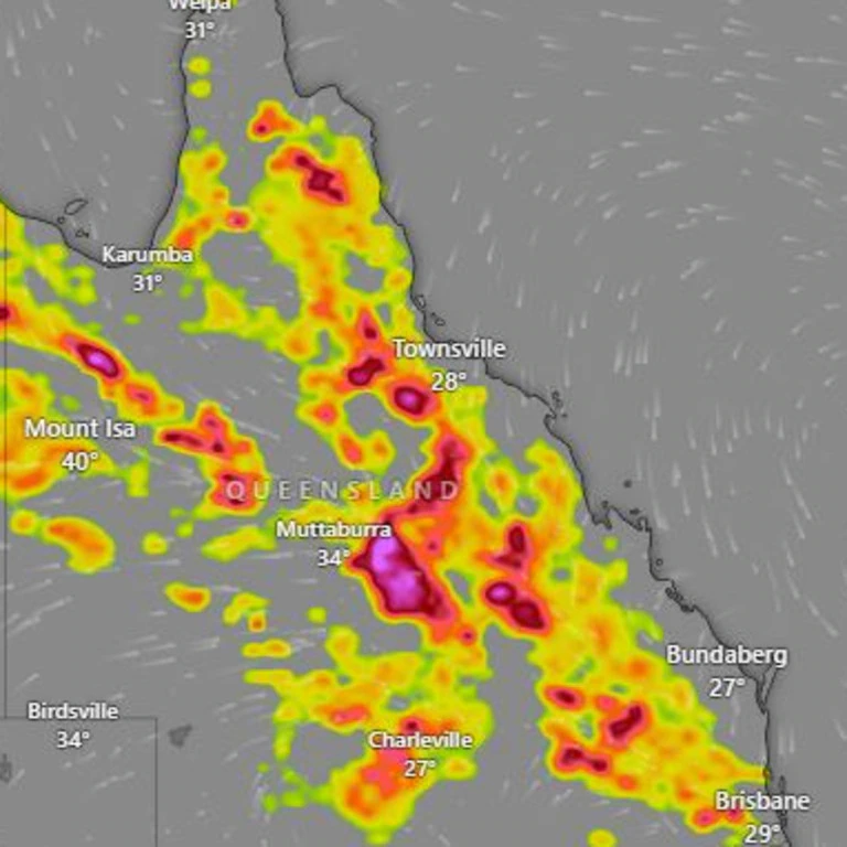
Almost entire state of QLD to be rained on with severe storms likely in some regions
Brisbane and parts of the southeast have been hit by a long line of severe thunderstorms, with reports of 10cm hail and dozens of cancelled flights, while 10,000 homes were left without power due to damage caused by heavy rain and powerful wind gusts.
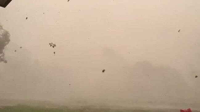
Brisbane and parts of the southeast have been hit by a long line of severe thunderstorms, causing dozens of flight cancellations and one area reporting 10cm hail.
The long line of storms delivered heavy rain and destructive winds across much of the southeast, from the Darling Downs to the NSW border, and the Sunshine Coast to the Gold Coast, with multiple warnings issued as they headed east.
Storm activity caused havoc at Brisbane Airport with dozens of flights cancelled.

Brisbane Airport spokesperson Peter Doherty said 34 flights in and out of Brisbane’s domestic terminal were cancelled due to severe storm activity, with “the safety of the travelling public the highest concern”.
Mr Doherty added airlines were working hard to rebook customers on the next available flight and advised passengers to get in touch with their carriers.
“Operations at Brisbane Airport are now very much back to normal,” he said on Friday night.
About 55,000 passengers were expected to travel through the domestic terminal, where 19 arriving flights were listed as cancelled -15 after 4pm.


One Glenorie resident reported hail measuring 10cm in diameter falling at his property
More than 10,681 Energex customers have been left without power following the stormsm 4000 of which are on the Sunshine Coast.

Major outages in Beerwah have left 1654 people without power as well as 1284 people in the Glasshouse Mountains.
Another major outage in Upper Mt Gravatt has been caused by the severe weather, with 1056 people being affected.

While wet conditions over the southeast continued into Friday night, the immediate threat of severe thunderstorms had passed by 6.29pm.
According to The Bureau, severe thunderstorms were no longer affecting the Southeast Queensland area, east of Dalby from Rainbow Beach to Stanthorpe.
The Bureau cancelled the severe thunderstorm warning for people in Logan, Gold Coast and Redland City Council Areas but said the situation will continue to be monitored and further warnings will be issued if necessary.
“Unusual” early morning heat and humidity created the perfect conditions for the evening storm, with Brisbane hitting 33C at 10am – making it almost the hottest place in Queensland, just slightly cooler than Burketown and Richmond at 33.9C.
Meanwhile, it was 31.8C on the Sunshine Coast and 31.1C at Gatton. In comparison, it was only 28.4C in Birdsville.
Bureau of Meteorology senior meteorologist Shane Kennedy said it was unusual to have been so warm so early in the day.
“We are expecting it to creep up to 34C for Brisbane today,” he said.
“But we are hoping for cloud cover and storms to cap that into the afternoon when we expect those showers to come through.”
Mr Kennedy said temperatures across the state were about 3-6C above average, while Brisbane was 7C above average on Thursday.
“It’s been caused by north and north-westerly winds with a weak trough system of hot air sitting across Queensland,” he said.
“ … that’s why we have that severe to extreme heatwave up at Cairns and Townsville
Mr Kennedy said Ipswich could reach 36C today while Doomadgee in the state’s far north was forecast to reach 41C.
He said the heat would remain over the weekend with humid temperature across the state.
The Bureau of Meteorology forecast scattered showers and thunderstorms on Friday covering most of the state, inland from the east coast north of St Lawrence between Mackay and Rockhampton.
They are also expecting severe thunderstorms with parts of central, southern and southeast Queensland to likely be hit with damaging winds, large hail, and heavy rainfall with localised flash flooding.
The Bureau said a trough will move back west across the interior from Friday, resulting in the return of more humid and unstable conditions in the southeast, amid a “low intensity heatwave”.
After a mostly sunny Friday morning for the southeast coast, The Bureau is expecting a high chance of showers and a chance of a thunderstorm in the afternoon and evening.
Daytime temperatures are forecast to reach the low to mid 30s, with Brisbane expected to hit 33C and Ipswich to climb to 36C, with light north to north-westerly winds.
The Wide Bay and Burnett forecast district has the chance of severe storm activity with damaging winds and large hail in the afternoon and evening plus the chance of heavy falls.
In the Darling Downs and Granite Belt there will be a high chance of showers in the afternoon and evening.

From the late morning there will be the chance of a thunderstorm, possibly severe in the north with damaging winds and large hail and heavy rain in the north in the afternoon and evening.
Conditions are expected to stabilise from next week as a high will move eastwards across the Southern Ocean over the weekend.
It is expected to strengthen a ridge over most of Queensland from early next week, with a south-easterly wind change spreading north along the east coast from Monday.
This is likely to result in a period of more settled weather for much of the state next week, according to the Bureau.