Queensland weather: Severe thunderstorms forecast for southeast tonight, possible 100mm rainfall
Severe thunderstorms are forecast to impact South East Queensland tonight ahead of a potential “significant” rain event over coming days.
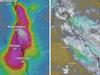
Severe thunderstorms producing heavy rainfall, large hail and damaging winds across South East Queensland tonight could be followed by days of drenching rain from the NSW border to Mackay.
The potential for a “significant” rain event that could see falls in excess of 100mm across an 1100km stretch of the Queensland coast is being triggered by a low pressure trough.
“Its influence is essentially just shifting a touch further north and east, so that puts the storm risk into the afternoon and evening for South East Queensland,” Sky News Weather meteorologist Alison Osborne said.

“There is quite a decent chance of severe storms for parts of the southeast.
“We’re more likely to see severe storms probably late afternoon, early evening.”
A Bureau of Meteorology spokesperson said isolated severe thunderstorms were most likely to impact South East Queensland tonight, before more settled conditions from Friday.
“Drier conditions are expected to return to the south east on Friday, with just the outside chance of light showers,” a spokesperson said.
Three-day totals from Friday could exceed 60mm across the Hervey Bay and Bundaberg regions.
Rain areas with locally heavy falls are forecast across the northern Peninsula and Torres Strait over the next few days.
“Which may lead to localised flash flooding along with renewed river rises given the saturated conditions in the area,” a spokesperson said.
There is also a current flood watch in place across northern Peninsula catchments.
“Non-severe storms are broadly possible over southeastern and central parts of the state, south of about Longreach to Rockhampton and east of Longreach to Thargomindah,” the spokesperson said.
With showers expected to increase across southeastern Queensland and parts of Central Queensland over the weekend, with some areas expecting 50 to 100mm of rain.
“This activity may even tend to areas of rain with some moderate to locally heavy fall possible, especially near the coast. Localised falls 50 to 100mm possible over the weekend and isolated 30 – 50mm with thunderstorms today, though activity likely to be mobile,” a spokesperson said.
For upcoming flood watch and marine wind warnings residents are urged to check the Queensland Warnings summary on the Bureau of Meteorology.