
Qld weather: Storms, heavy rain, heatwave conditions
South East Queensland is bracing for severe storms and intense rainfall as weather experts warn “dangerous and life-threatening flash-flooding” could hit several regions from early Tuesday.
QLD weather news
Don't miss out on the headlines from QLD weather news. Followed categories will be added to My News.
South East Queensland is bracing for severe storms and intense rainfall as weather experts warn “dangerous and life-threatening flash-flooding” could hit several regions from early Tuesday.
A slow-moving weather system, bringing severe storms and heavy rain was last night over western regions and heading for the South East.
At 10:04pm The Bureau cancelled the thunderstorm warning for people in Cherbourg, Gympie, Western Downs, South Burnett and Toowoomba Council Areas.120mm recorded at Cherbourg in the 2 hours to 8pm before the immediate threat of very dangerous thunderstorms had passed.
At 8:45pm a dangerous thunderstorm was detected near Goomeri and the area north of Kilkivan.
The Bureau of Meteorology said the storm was moving towards the southeast and was forecast to affect Murgon, Goomeri and Kilkivan, then the ranges between Gympie and Murgon, and after the area northwest of Gympie and Cherbourg.
Another severe thunderstorm was detected near the area southwest of Dalby and Jandowae. Other severe thunderstorms likelyto produce heavy, locally intense rainfall that may lead to dangerous and life-threatening flash flooding were detected near Macalister. These thunderstorms were moving towards the southeast to southwest.
More storm cells were expected to form overnight and into Tuesday morning.
Heavy, locally intense rainfall is possible with any storm fronts that form.
At 7:55pm The Bureau warned the storms had intensified to be very dangerous, likely to produce heavy, locally intense rainfall that may lead to dangerous and life-threatening flash flooding.
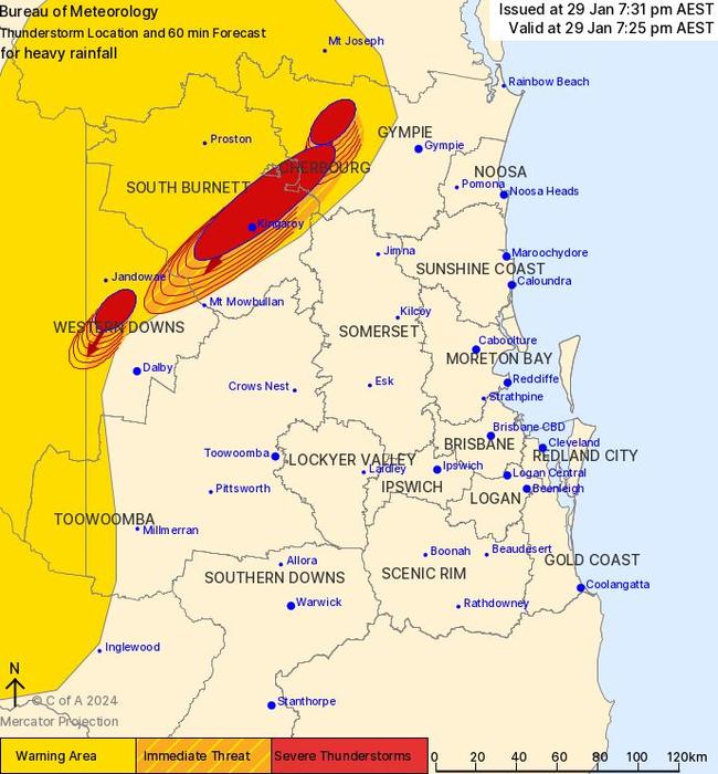
They were detected near Kingaroy, the area west of Kingaroy and Kilkivan and were forecast to affect the ranges between Gympie and Murgon, Cherbourg and Goomeri by 8:25pm and the area northwest of Kingaroy by 8.55pm.
Other severe thunderstorms likely to produce heavy, locally intense rainfall that may lead to dangerous and life-threatening flash flooding were detected near Macalister.
These thunderstorms were moving towards the southeast to southwest.
The Bureau forecast them to affect the area north of Dalby, Jimbour and Bell by 8:25pm and Dalby, the area southwest of Dalby and the area northeast of Dalby by 8:55pm.
In the Bureau of Meteorology’s updated warning for Monday night, issued at 7.31pm, it warned people in Cherbourg, Gympie, Western Downs and South Burnett council areas of heavy rainfall.
It said severe thunderstorms likely to produce heavy rainfall that may lead to flash flooding were detected at 7.25pm Monday.
The storms were detected near Kingaroy, the area northeast of Kingaroy and Kilkivan.
“They are forecast to affect the area south of Kingaroy, the ranges between Gympie and Murgon and Jimbour by 7.55pm,” the warning said.
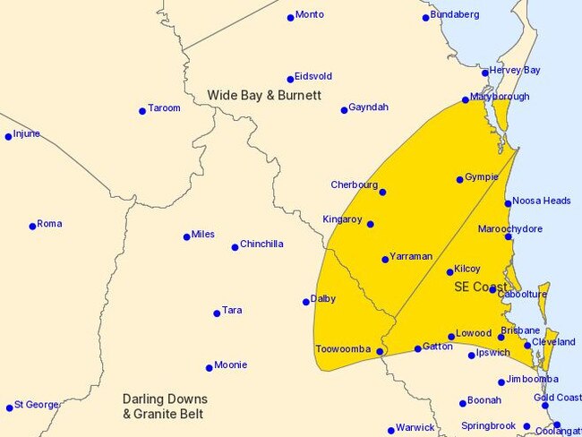
The warnings for heavy rainfall in the southeast on Tuesday were for people in parts of Wide Bay and Burnett, Darling Downs and Granite Belt and Southeast Coast forecast districts, saying they expected heavy, locally intense rainfall over southeast Queensland from early Tuesday.
“A surface trough over southeast Queensland is expected to sharpen during Tuesday, then gradually move north during Wednesday, which will enhance the already very moist onshore flow over the region,” the warning, issued at 4.23pm Monday, said.
“Heavy rainfall which may lead to flash flooding is forecast for areas north of about Toowoomba, Ipswich and Beenleigh, east of Dalby, and south of Cherbourg and Maryborough from early Tuesday morning, including Brisbane.
“Six-hourly rainfall totals between 80mm to 120mm are likely.
“Locally intense rainfall which may lead to dangerous and life-threatening flash flooding is also possible over the warning area with six-hourly rainfall totals between 150mm to 200mm.”
The Bureau said there was “some degree of uncertainty” around the positioning and movement of the trough but the warning said locations which may be affected include Toowoomba, Brisbane, Maroochydore, Gympie, Kingaroy and Caboolture.
The weather bureau’s Felim Hanniffy said southeast Queensland was still locked in a “very humid air mass” as daytime maximums had cooled, meaning humidity would stick around until Wednesday.
“It will become probably a little less humid as as the trough driving the weather shifts northward,” he said Monday night.
Mr Hanniffy said that lingering trough and a coastal trough development would bring with it the risk of heavy to local intense rainfall around parts of the southeast Tuesday and Wednesday.
“The risk area is very much just north of Beenleigh, including Brisbane, up to the Sunshine Coast and southern parts of the Wide Bay and Burnett, to about Maryborough,” he said.
“Then the risk area extends inland including parts of Kingaroy, down to parts of the Darling Downs including Dalby and Toowoomba as well.”
The forecaster said other areas not within the warning area may soon be included in it as the coastal trough’s development and movement becomes more certain.
“If that coastal trough were to develop and be a little bit further south, it could target more southern areas, but at this stage looks like the focal point will be north about Beenleigh.”
Mr Hanniffy said the main rain risk period would be Tuesday into Wednesday as the system will start to contract northward.
“So we’ll probably see their sources of severe weather warning contracting more probably north of Brisbane and the Sunshine Coast northward and then generally probably easing through the latter part of Wednesday,” he said.
“So the rainfall risk probably reduces after Wednesday, though any flooding that occurs is likely to continue probably into Thursday as well, though the rainfall should have eased by that stage.”
The storms come as the southeast swelters through intense humidity which may be a driver behind the storms.
“Certainly very high moisture levels at the moment around the southeast, you know, moisture levels akin to what you normally associate in an active monsoon period up north.” Mr Hanniffy said.
“That means certainly if you see showers or thunderstorms, or coastal trough, then there’s potential to access that moisture and generate some localised very heavy and if not intense rainfall when they do occur.”
It came after southeast Queensland was expected to be the most humid part of Australia on Monday as the rest of the state battles high rainfall totals and ex-tropical Cyclone Kirrily’s strong winds.
Gold Coast residents were on Monday afternoon told to “prepare now” in anticipation of more heavy rain, as a flood watch has been issued for the already waterlogged southeast, with a trough expected to bring heavy showers and thunderstorms over the coming days.
Queensland recorded its second-highest measure of water in the air in seven years, with 70.8mm recorded on Monday morning, only 0.1mm lower than the record of 70.9 in March 2017.
“The precipitable water value shows how much water is available in the air for when that rain does come,” Bureau meteorologist Livio Regano said.
“When the storms happen, there will be a lot in them.”
Mr Regano said this week’s high humidity markers have been caused by an overheated ocean and tropical origin winds.
“Ocean temperatures are currently sitting above 30C at the moment, Moreton Bay has hit 30C, when it should be 4 to 5 degrees lower so what should be a cool breeze coming off the water feels more like a hair dryer,” Mr Regano said.
“As well as that, what’s also causing the humidity is the wind that is from tropical origin, a breeze that is being pushed down from the northern part of the Coral Sea rather than from the south.
“That’s causing a high dew point which in turn causes the high humidity which leads to us sweating for most of the day and well into the night.”
Ex-tropical Cyclone Kirrily’s wind patterns are also partially to blame for Monday’s conditions around Southeast Queensland as well as high rain totals expected in the next coming days.
“It is hard to pinpoint exactly where the highest rainfall totals will be, especially tomorrow, it is very random,” Mr Regano said.
“We could easily have 100ml in the next 24hrs anywhere from the Sunshine Coast to the Gold Coast to the Brisbane metro area.
“It is possible to have well over 200ml over the two-day period.”
‘PREPARE NOW’: STORMS EXPECTED, FLOOD WARNINGS ISSUED
Gold Coast residents have been told to “prepare now” in anticipation of more heavy rain, as a flood watch has been issued for the already waterlogged southeast, with a trough expected to bring heavy showers and thunderstorms over the coming days.
The Bureau of Meteorology on Monday warned widespread minor flooding was likely in Southern and Central Queensland early this week with moderate to major flooding possible in some areas.
On Monday, flood warnings were issued across southeast Queensland, with forecasts for locally intense rainfall that may lead to flash flooding as a deep trough system interacts with deep tropical moisture lingering in the southeast.
“Flood watch has been issued for southeast Queensland due to that heavy rainfall is also a major flood warning for Laidley Creek,” Bureau of Meteorology community information officer Brooke Pagel said.
“The catchments we are looking at are Sunshine Coast, Upper Brisbane River, Lower Brisbane River and we’re keeping an eye on Noosa River, Mary River to basically southern and central Queensland including southeast Queensland.”
Jump to:Catchments affected
Ms Pagel also said that rainfall could exceed 50mm in southeast Queensland if severe thunderstorms develop.
“We may see high totals embedded in severe thunderstorms going into tomorrow. We are expecting between about 50 to 100 millimetres across southeast Queensland,” she said.
“For Tuesday and Wednesday we’re expecting severe thunderstorms to develop, higher isolated totals are possible.”
The City of Gold Coast has urged residents to prepare now in light of a fresh batch of storms expected to lash the area late Monday afternoon.
The severe weather advice was released by the council on Monday morning following the Bureaus forecast of heavy showers, thunderstorms and flash flooding in the area.
“The Bureau of Meteorology has advised there is a strong chance of heavy showers, thunderstorms and locally intense rainfall with an increased risk of flash flooding from late this afternoon and overnight across the Gold Coast,” the warning said.
“You should PREPARE NOW as conditions could become dangerous.”
The warning comes after the Gold Coast was severely damaged over Christmas and Boxing Day by a rogue tornado that left thousands without power and several people dead.
A severe thunderstorm forecast issued on Monday shows most of the South East and Central West is in for possible severe thunderstorms.
Ms Pagel said the area they are looking at is broad and the effects of the possible storms will be widespread.
“The key areas that we are looking at with these thunderstorms are basically South East Queensland and through to central and western Queensland so the metropolitan areas are a key risk with the severe weather,” she said.
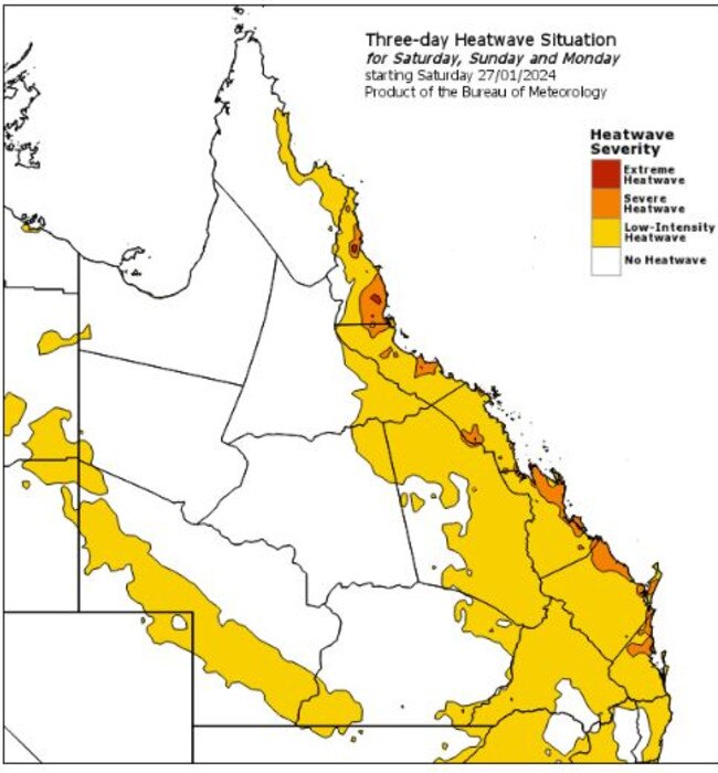
Heatwave warnings are still in place for eastern Queensland and north tropical Queensland including Cook Country, Rockhampton, Brisbane, Sunshine Coast, Gold Coast and Darling Downs.
Humidity throughout southeast Queensland has not eased over the weekend with Ms Pagel warning that high humidity and warm conditions may not ease over the next few days.
“The humidity levels that we’re seeing in Brisbane, for example, at the moment is similar to what we usually see in Far North Queensland.” Ms Pagel said.
Bureau metrologist Brooke Oakley said BOM are expecting the area to reach the 90 per cent humidity mark, making high maximum temperatures in the low 30s feel even warmer.
“For much of Southeast Queensland, all the way out to Charleville, up to Longreach and even as high up as Mount Isa, the temperature might be forecast as between the mid 20s to low 30s, but it will definitely feel a lot warmer,” Ms Oakley said.
“Brisbane is currently sitting at 29C but it feels more like 36C so really warm today, plus the humidity marker is already at 80 per cent.
“Not only is the humidity forecast to reach 90 per cent but to dew point is also very high, for most of the day around Queensland it will sit around that 25 to 26 per cent which is really high; very similar to the last couple of days.
“Right across the state the morning, it is very sweaty.”
Brisbane’s humidity markers are not only the highest across Australia as of 11am Monday morning, they are also higher than Bali and Singapore.
As well as high humidity, Ms Oakley said BOM are closely monitoring a set of storms expected to lash the area late Monday night that are forecast to hang around for most of the week.
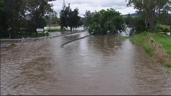
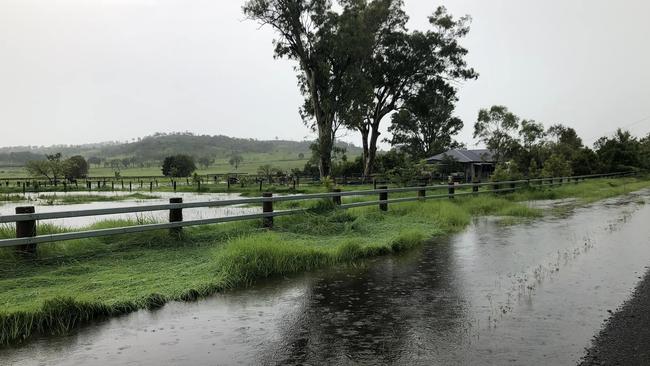
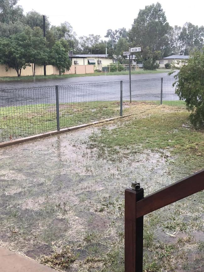
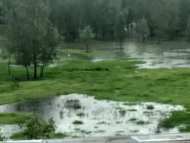
It comes after a wet weekend with large parts of South East Queensland lashed by heavy rainfall from early Sunday, including some areas that recorded more than 230mm.
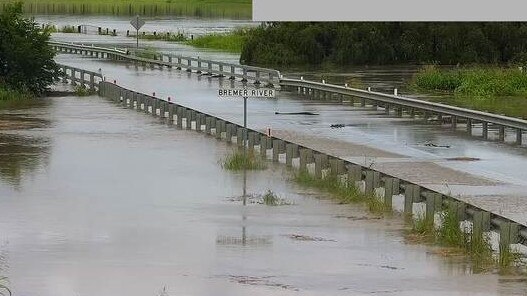
River and creek levels were still rising Sunday night after the deluge, including the Bremer River which was expected to hit minor flood levels at Ipswich, and Warrill Creek which was predicted to hit major flood levels at Harrisville and Amberley.
Rainfall totals between 150 and 200mm were recorded throughout the Lockyer Valley, while areas across Brisbane averaged falls between 50mm and 70mm.
Falls as high as 234mm were recorded at Mulgowie, near Laidley, while Luggage Point, near the Brisbane airport, recorded 101mm of rain, and Bahrs Scrub, near Beenleigh, recorded 115mm.
“Over the coming days will continue to see showers and thunderstorms and given how much moisture is in the air, any of those thunderstorms could lead to heavy falls and from that, river level rises,” Bureau meteorologist Harry Clark said.
“In South East Queensland the ground is quite wet after (Sunday’s rain) which means that any rainfall will make it much easier for it to turn into flash flooding and riverine flooding.”
Flood warnings are in place for the Georgina River, Eyre Creek, Flinders River, Western River, Diamanina River, Warrill Creek, Bremer River, Lockyer Creek, Herbert River, Logan River, Albert River, Norman River, Gilbert River, Thomas River, Barcoo River, Cooper Creek, Bulloo River and Upper Burdekin River.
■ Power outages: All your questions answered
While the Scenic Rim, Lockyer Valley and Brisbane enjoyed cooler temperatures brought on by the heavy rain, further north, residents were sweltering through record breaking heat.
“We saw a number of records broken in terms of the warmest minimum temperature for the Sunshine Coast and Wide Bay area for minimums (Sunday) morning,” Mr Clark said.
Tewantin, near Noosa, dropped to 27.4C – the warmest night on record at that station which has 29 years of data.
Gympie had its warmest night in 59 years of records, getting down to 27.2C.
And the Gladstone Radar weather station recorded its warmest January night on record of 27.4C.
“Those numbers are high but they were really exacerbated by the humidity, so the apparent temperature would have been in the low 30s,” Mr Clark said.
“It’s been fairly horrible with that humidity around so temperatures have felt much worse, so quite significant heat.”
Meanwhile forecasters are still monitoring ex tropical cyclone Kirrily which is moving extremely slowly in the state’s northwest.
“It’s sitting west of Winton and south of Julia Creek,” Mr Clark said of the system.
“Heavy rainfall is still occurring around the system and it will remain quite slow moving over the coming days.
“That event is not over, it is still continuing in the northwest but mostly falling in isolated areas.”
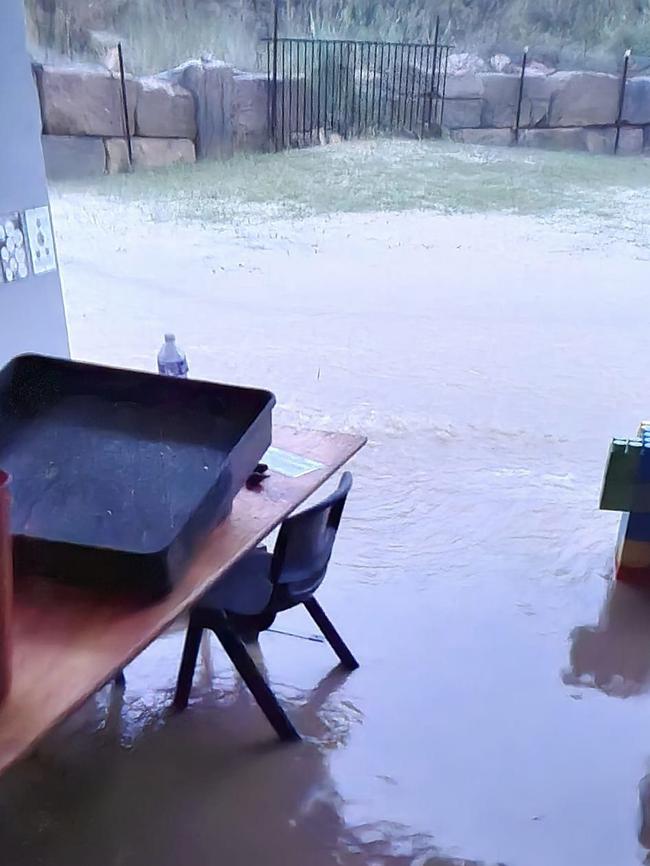
Wayne Rolph, who lives at Rosewood west of Amberley, was one of the many people trapped by rapidly rising floodwaters at Seven Mile Bridge on Rosewood Road on Sunday.
“I went across 10 minutes earlier to go to the service station and saw the water was lapping at the bottom of bridge and when I came back, it was well over,” Mr Rolph said.
“That was about 2.30pm and it was still coming up (late Sunday).”
Catchments likely to be affected include:
Dawson and Don Rivers
Comet and Nogoa Rivers
Burnett River
Mary River
Noosa River
Sunshine Coast Rivers and Creeks
Pine and Caboolture Rivers
Upper Brisbane River
Lower Brisbane River (Flood warning current from earlier rainfall. Lower Brisbane River not at risk at this stage)
Logan and Albert Rivers (Flood warning current from earlier rainfall)
Gold Coast Rivers and Creeks
Condamine Rivers
Macintyre River
Weir River
Moonie River
Balonne River
Wallam and Mungallala Creeks
Warrego River (QLD)
Paroo River (QLD) (Flood warning current from earlier rainfall)
Bulloo River (QLD)
Bureau of Meteorology senior meteorologist Harry Clark said a slow-moving system soaked the southeast Sunday morning, with falls as high as 234mm recorded at Mulgowie, near Laidley.
Sweltering temperatures in recent days created ideal conditions for extensive thunderstorm activity starting in the early hours of Sunday, developing in the Warwick area and moving across the Lockyer Valley, Scenic Rim, Beenleigh, Logan and Brisbane.
Rainfall totals between 150 and 200mm were recorded through the Lockyer Valley by Sunday night while areas across Brisbane averaged falls between 50mm and 70mm.
Luggage Point, near the Brisbane airport, recorded 101mm of rain.
Bahrs Scrub, near Beenleigh, recorded 115mm.
The Bureau of Meteorology has warned minor flooding is now possible along the Bremer River at Ipswich overnight Sunday after rapid river and creek rises were recorded.
In its latest alert, the Bureau said major flooding was likely along Warrill Creek at Harrisville and Amberley from Sunday afternoon, with peaks near the major flood level possible along the Bremer River at Five Mile Bridge and Walloon from Sunday evening.
“Significant heavy rainfall with thunderstorms have been recorded across the Brisbane region Sunday morning with widespread totals 50-170mm in the early hours of Sunday morning and isolated rainfall totals up to 234mm,” the Bureau said.
“Rapid river and creek rises have occurred and flood peaks are now moving through Warrill Creek and the Bremer River towards Ipswich.
“Minor flooding is now possible along the Bremer River at Ipswich overnight Sunday into Monday.
“The situation is being closely monitored and warnings will continue to be updated as required.”
IN THE REGIONS
While the southeast braced for the possibility of dangerous storms and intense rainfall, residents in the state’s west were grateful for the deluge despite the possibility of seven weeks isolated due to flooding.
Winton Mayor Gavin Basket said he had spoken to graziers in his electorate who would “never whinge about rain”, but acknowledged it had come in hard and fast.
“Middleton, about 90 kilometres west from Winton, recorded over 500mm from Saturday morning until (Monday) afternoon, so they’re probably headed toward 600mm,” he said.
“It’s flooding pretty severely, like the waters three metres over the road and rising on Winton Bouila Rd at Middleton.”
“North of Middleton they’re probably gonna be isolated for six, seven weeks before they’ll be able to get into civilisation, it’s good rain, but a lot of rain.”
The Mayor said the flooding would mostly impact graziers with damaged fences and lost stock.
“Other than that they’re pretty happy with the rain they get, it’d be better if it was over a month period, but you take it as you can get it out here,” he said.
“Floods, and bloody, these sort of storms are the lifeblood of this country … a lot of these countries will be right for the year now.”
“The Diamantina is going to have a massive run in it heading down, so Birdsville in about a month or so we’ll get all that water heading past them.”
A severe thunderstorm warning for heavy rainfall was updated at 4.47pm Monday for people in parts of Northern Goldfields and Upper Flinders, North West, Central West and Channel Country forecast districts.
“Ex-Tropical Cyclone Kirrily is currently located just northeast of Brighton Downs. It is forecast to remain slow-moving across the western interior tonight and through to Wednesday,” the warning said.
“Looking ahead, the system is expected to meander across the interior of the state, most likely starting to turn north on Thursday, although there is vast uncertainty as to its future track and intensity. HEAVY RAINFALL which may lead to FLASH FLOODING is forecast for the southeastern North West, western Central West, northern Channel Country and far southwestern Northern Goldfields & Upper Flinders districts.
“Six-hourly rainfall totals are likely to pick up again from this evening, with between 60 to 90mm likely and isolated falls up to 120mm possible. Twenty-four-hourly rainfall totals through to Tuesday afternoon of 90 to 140mm are also likely to continue, with isolated falls up to 280mm
Locations which may be affected include Boulia, Stonehenge, Selwyn, McKinlay, Brighton Downs and Middleton.
A Flood Watch and several Flood Warnings are also current for the Central West, Channel Country and Gulf of Carpentaria catchments.
The Bureau reported 256mm of rain had fallen at Seymour Gap between 9am Sunday and 9am Monday, while in the same period 244mm had been recorded at Kirby and 154mm at McKinlay.
A separate severe thunderstorm warning for damaging winds and heavy, locally intense rainfall was updated at 6.58pm Monday for people in parts of Central Highlands and Coalfields, Capricornia, Wide Bay and Burnett, Maranoa and Warrego and Darling Downs and Granite Belt forecast districts.
“Severe thunderstorms are likely to produce damaging winds and heavy rainfall that may lead to flash flooding over the next several hours in parts of the Central Highlands and Coalfields, Wide Bay and Burnett, Maranoa and Warrego and Darling Downs and Granite Belt districts,” it said.
“Locations which may be affected include Roma, Charleville, Kingaroy, Goondiwindi, Mitchell and Tara.
“VERY DANGEROUS THUNDERSTORMS are likely to produce heavy, locally intense rainfall that may lead to dangerous and life-threatening flash flooding and damaging winds over the next several hours in parts of the Maranoa and Warrego and Darling Downs and Granite Belt districts.
Severe thunderstorms are likely to produce heavy rainfall that may lead to flash flooding over the next several hours in parts of the Capricornia and Central Highlands and Coalfields districts. Locations which may be affected include Theodore and Moura,” the warning said.
It comes after 73mm fell in the hour to 2.44am Monday at Tanderra (southern Central Highlands), 60mm of rain fell in the hour to 2.01am Monday at Upper Van Dyke (southern Central Highlands), 57mm in the hour to 5.07am at Consuelo Alert (southern Central Highlands) and 53mm fell in the hour to 6.43am at Wallumbilla TM (east of Roma).
Wind gusts up to 102km/h were recorded at St George Monday afternoon.
SUNDAY
The Bureau said minor flooding could also occur along the Lockyer Creek at Glencore Grove, while moderate flooding was expected to begin easing along the Laidley Creek.
The Bremer River at Ipswich was at 2.07 metres and rising on Sunday afternoon, below the minor flood level of 7m.
The Bureau said the Bremer River at Ipswich may reach the minor flood level of 7m) overnight Sunday into Monday.
Meanwhile, the Warrill Creek at Harrisville was at 4.90 metres and rising rapidly, above the moderate flood level of 4m with predictions it is likely to exceed the major flood level of 5m by this afternoon.
“The river level may peak near 5.40m Sunday evening,” the Bureau said.
“The Warrill Creek at Amberley is currently at 6.08 metres and rising, above the moderate flood level (5.50 metres).
“The Warrill Creek at Amberley is likely to exceed the major flood level (6.50m) late Sunday afternoon. The river level may peak near 6.80 metres Sunday evening.”
Mr Clark had on Sunday morning said moderate falls were expected to continue before the system moved offshore Sunday afternoon.
“There are definitely still a number of flood warnings current out in that Lockyer Valley area as a result of that rainfall they had,” he said Sunday morning.
“The main ones would be a major flood warning for Laidley creek at Laidley and then we have a moderate flood warning for the Bremer River at Rosewood.”
Mr Clark said forecasters could not rule out further heavy falls in coming hours, mostly around the Sunshine Coast before the system went out to sea Sunday afternoon.
While the wet weather delivered a reprieve from scorching temperatures, areas further north were not so lucky.
“We were fortunate enough here to get the storms come through early morning which meant it took the edge off the temperatures but areas further north around the Sunshine Coast it was a really hot night because they didn’t get that storm activity,” Mr Clark said.
“We saw a number of records broken in terms of the warmest minimum temperature for the Sunshine Coast and Wide Bay area for minimums this morning.”
Tewantin, near Noosa, dropped to 27.4C – the warmest night on record at that station which has 29 years of data.
Gympie had its warmest night in 59 years of records, getting down to 27.2C.
And the Gladstone Radar weather station recorded its warmest January night on record of 27.4C.
“Those numbers are high but they were really exacerbated by the humidity, so the apparent temperature would have been in the low 30s,” Mr Clark said.
“It’s been fairly horrible with that humidity around so temperatures have felt much worse, so quite significant heat.”
Mr Clark said forecasters were now monitoring the potential for further rainfall in the Southeast in coming days.
“Certainly the next few days will be very, very unsettled across south eastern Queensland,” he said.
“So we will need to keep an eye out for further severe thunderstorm activity with heavy rainfall being that main threat.
“And given we’ve had all this rain now, if we do get heavy rainfall, flash flooding is quite likely and we couldn’t rule out some riverine flooding as well. Once again not for the city or anything like that but mainly the smaller ones that go up a bit quicker in the Scenic Rim and Lockyer Valley area.”
He said there was “a lot of uncertainty” about the potential for rain on Tuesday.
“It’s dependent on a coastal trough forming which are notoriously fickle, the modelling can change very quickly because of very subtle small subtle features but it can lead to high rainfall totals,” he said.
“So we’ll be keeping a close eye on that for Tuesday and if that does happen, we could see some quite heavy rainfall around southeast Queensland.”
“It’s not a certainty, but definitely something we need to be aware of the risk of.”
FLOOD WARNINGS
Flood warnings have been issued for a number of Queensland rivers as heavy rainfall continues to lash the southeast.
It comes as thousands of properties have been hit by power outages as the region was hit by heavy rain and again endured sweltering heatwave conditions overnight Saturday night.
The overnight deluge saw 96mm of rainfall in the hour to 1.57am at the Bureau’s Mt Berryman Road alert observation station, south of Gatton.
At the Romani Alert observation station 67mm of rain fell in the hour to 2.25am, while 55mm fell at Round Mountain near Logan in the hour to 2.15am. Upper Tenthill, southwest of Gatton, recorded 47mm in just half an hour before 1.23am.
Brisbane had recorded 26.4mm of rain by 6.30am.
A severe thunderstorm warning for people in Logan, Gold Coast, Redland City and Brisbane was cancelled at 3.42am although thunder, lightning and heavy rain continued.
The Bureau of Meteorology issued a minor flood warning for the Logan River, with flooding possible at Beaudesert and Wolffdene Sunday morning and at the Maclean Bridge by Sunday afternoon.
Heavy rainfall and thunderstorms have dumped 50mm to 90mm in areas in the Logan and Albert river catchments since Sunday morning.
“The Logan River at Beaudesert is currently at 1.47 metres and rising, below the minor flood level (5.5m),” the alert said.
“The Logan River at Beaudesert may reach the minor flood level (5.5m) Sunday morning.
“Further rises are possible with forecast rainfall.”
Some Logan residents had said they’d been “flooded in” by 9.30am, after roadways were cut.
The Logan Council has made sandbags available.
Minor flooding may also occur along the Albert River which is currently at 2.55m and rising, with the Bureau predicting the river to reach its minor flood level of 6m this morning with further rises possible.
Meanwhile, major flooding is expected along Laidley Creek at Laidley on Sunday morning, with an 8.5m peak predicted.
Moderate flooding is also possible along the Bremer River at Rosewood, Five Mile Bridge and Walloon later this morning.
Moderate flooding is predicted along the Lockyer Creek at Glenore Grove and along Warrill Creek at Harrisville this afternoon.
“Significant heavy rainfall with thunderstorms have been recorded across the Brisbane region Sunday morning with widespread totals 50-170mm in the early hours of Sunday morning and isolated rainfall totals up to 234mm,” the Bureau’s alert said.
“Rapid river and creek rises are occurring and warnings will be updated as required.”
The Bureau said the Laidley Creek may peak around 8.5m, which is below the levels recorded in the 2011 and 2013 floods.
POWER OUTAGES HIT 9000+ AMID HEATWAVE CONDITIONS
Thousands of properties remain without power following a hot, wet night Saturday night.
At 1.30pm Sunday there were more than 1300 South East properties without power, most in the Brisbane and Redland areas. Earlier, at 9am there were more than 9200 properties without power, according to Energex.
The outages came after another hot, humid night, with a heatwave warning still in place for most of Queensland’s coast, including almost the entire southeast corner.
In Brisbane it was 24.7C at 5.20am but it felt like 29.5C, remaining reasonably steady at 9.10am on 24.6C (29.4C). The apparent temperature spiked to 30C by 5.50am.
It wasn’t as comfortable in parts of the Sunshine Coast, with the apparent temperature in Tewantin jumping to 36.8C at 9.10am. The actual temperature was 29.1C. At 5.20am it had been 27.5C with an apparent temperature of 33.2C.
At the Gold Coast Seaway it was 24.7C (28.3C) at 5.20am, rising to 25.5C (30.1C) at 9.10am.
The forecast has Brisbane looking to reach a top of 30C on Sunday with up to 35mm of rain expected.
The Gold Coast expected a top of 25C and up to 25mm of rain while the Sunshine Coast was headed for a top of 31C and up to 35mm of rain.
Power outages are also persisting in the state’s north in the wake of Tropical Cyclone Kirrily.

Ice ice baby: Spectacular images of unseasonal frost as Qld freezes
Queensland’s overnight temperatures will increase to double digits in the coming days, following the coldest start to winter in 16 years, bringing frost and ice to many regions. SEE THE PHOTOS

City’s coldest June start in 16 years, feels like MINUS 9.8C out west
Southeast Queensland is shivering through its coldest morning in more than 15 years but feels-like temperatures have dropped to insane levels in the southern inland.