
Queensland weather: Heatwave conditions, tropical humidity as temperatures climb to high 30s
Oppressive heatwave conditions have hit South East Queensland, with humidity levels akin to Cairns and Darwin driving the possibility of severe thunderstorms and heavy rainfall after the hottest night in seven years on Friday.
QLD weather news
Don't miss out on the headlines from QLD weather news. Followed categories will be added to My News.
Parts of the South East could be hit with severe thunderstorms tonight after the region sweltered through Saturday’s humidity levels akin to tropical regions like Cairns and Darwin.
The weather bureau’s Felim Hanniffy said Saturday’s heatwave reached “feels like” temperatures of 40C in Brisbane which sent plenty of moisture in the atmosphere.
Mr Hanniffy said the bureau was monitoring the threat of severe thunderstorms for Saturday night, given the high level of moisture.
The Bureau of Meteorology does not have any official warnings in place, as of 3.30pm.
“There are dew points akin to Cairns and Darwin. So when the storms come up there’s lots of moisture around,” Mr Hanniffy said.
“Localised heavy falls will be the primary watch point with a local risk of intense rain. Falls of 50-100mm, wouldn’t be out of the question.”
Mr Hanniffy said the threat of severe weather was forecast to continue on Sunday putting a potential dampener on the Gabba test match between Australia and the West Indies.
“The through is through the southern interior and slowly moving northward,” he said.
“The trigger point is the afternoon and evening following a bit of a reprieve early.”
Friday night was officially Brisbane’s hottest night since 2017 – not dropping below 27.2C – while St George recorded its highest minimum on record at 30.7C.
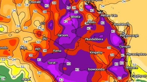
Before noon today, it got to 36.1C at Greenbank, while it is 34.5C in Brisbane and Archerfield, 34.1C at Amberley, 33.2C at Nambour, 35.2C at Gatton and 32.7C at Redcliffe.
It feels much warmer due to the high humidity, with the apparent temperature sitting at 40.2C in Brisbane and 40C in Gatton.
Further west, it is 37.2C in Goondiwindi, 37C in St George and 34.1C in Oakey.
Overnight, Brisbane felt like 35C at 10pm and 34C at 3am.
Conditions were similar on the Sunshine Coast, where the apparent temperature only dropped below 30C at 3am, and on the Gold Coast where it currently feels like 31.1C.
Severe storms are likely across north-east #NSW and large parts of #Qld this weekend with possible heavy rainfall and damaging winds.
— Bureau of Meteorology, Australia (@BOM_au) January 27, 2024
Localised river and creek rises are possible in parts of south-east #Qld in catchments which are already wet.
Latest: https://t.co/4W35o8i7wJpic.twitter.com/vJvG81OzMb
The dew point, which measures the actual amount of water vapour in the air, has sat at 25C since midnight, community information officer Brooke Pagel said while heatwave conditions were easing in southwestern Queensland, coastal areas such as the Sunshine Coast and Fraser Island have been issued heatwave warnings continuing into early next week.
“Its low intensity heatwave for a lot of the eastern parts of Queensland, and then through to Warrego, and Channel Country.
“We’re looking at those maximum temperatures in the high 30s to low 40s in some areas, reaching those high 40s over Channel Country … Birdsville is at 42 which will be the warmest in the state.” Ms Pagel said.
“We are looking at coastal areas having severe heatwave conditions, so little pockets in on the Sunny Coast and Fraser Island and then just some spots up in Mackay and North tropical coasts.”
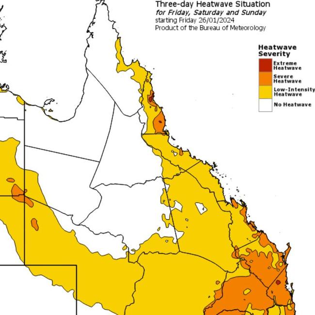
Ms Pagel said that humidity was at a high with Gladstone, Bundaberg and Mareeba recording dew points of around 27-28C.
“Anything that’s 24 degrees and above with those dew points, we do consider it to be oppressive … we’re looking at that easing from Tuesday onwards,” she said.
Ms Pagel also said they were looking at the chance of severe thunderstorms across the weekend into Tuesday next week.
“We have severe weather warnings up around western Queensland but most of inland Queensland, there is the risk of that severe thunderstorm activity, with rain being that key risk,
“South East Queensland is in the firing line [on Sunday] for severe thunderstorms with that heavy rainfall,” she said.
🌡ï¸Extremely high dew point temperatures >25 °C are blanketing QLD, and leading to apparent temperatures ~5 °C higher than the actual temperature. Here's why dew point is the best measurement of humidity: https://t.co/KAXKtlCByopic.twitter.com/RVBCDRvFDP
— Bureau of Meteorology, Queensland (@BOM_Qld) January 27, 2024
Flood watches have been issued in northern Queensland but are yet to be released in southern Queensland with residents encouraged to keep an eye on warnings.
Ms Pagel said the wind had dropped down significantly overnight as Cyclone Kirrily is disintegrating and is currently in a remnant low.
“[The cyclone] is still impacting the rain because there’s still a lot of moisture in it, but doesn’t have any kind of cyclonic rotation so the wind has backed right off.” Ms Pagel said.
“Even just looking at the last 24 hours, we didn’t see any significant wind gusts pass through, the highest wind gust was at Julius Dam yesterday morning, at about six o’clock and that was a 96km/h gust.”
Today it is expected to get to 38C in Ipswich and Esk, 37C in Brisbane, Caboolture, Gatton and Laidley, and 35C on the Sunshine Coast and in Logan.
There is a high chance of showers in the south and the chance of a thunderstorm with possibly heavy rainfall this afternoon and tonight. Damaging winds are possible.
Read related topics:Weather
Join the conversation

Ice ice baby: Spectacular images of unseasonal frost as Qld freezes
Queensland’s overnight temperatures will increase to double digits in the coming days, following the coldest start to winter in 16 years, bringing frost and ice to many regions. SEE THE PHOTOS
Read more

City’s coldest June start in 16 years, feels like MINUS 9.8C out west
Southeast Queensland is shivering through its coldest morning in more than 15 years but feels-like temperatures have dropped to insane levels in the southern inland.
Read more