
Qld weather: ‘Severe weather action’ forecast as Cyclone Seth tracks south
Authorities have warned coastal communities to brace for ‘severe weather action’ as the first cyclone of 2022 moves south. FULL LIST OF BEACH CLOSURES
QLD weather news
Don't miss out on the headlines from QLD weather news. Followed categories will be added to My News.
Disaster centres are on standby and authorities on high alert as the first cyclone of 2022 hovers off the Queensland coast, whipping up wild waves, strong winds and rain.
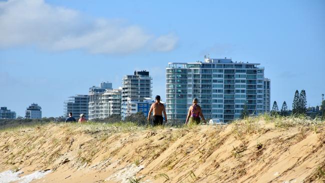
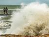
Scores of beaches on the Gold and Sunshine coasts have been closed as powerful swells generated by Ex-Tropical Cyclone Seth, coupled with king tides, slammed the southeast.
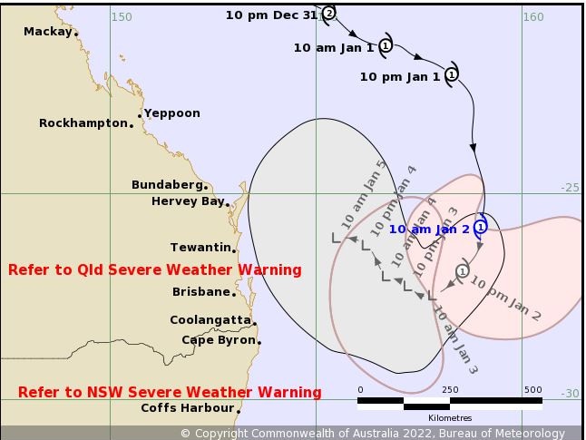
At 4pm on Sunday, Ex-Tropical Cyclone Seth was located about 590km east southeast of Hervey Bay and 560km east of Brisbane.
The system is moving south southwest at 15 kilometres per hour.
The Bureau of Meteorology said Ex-Tropical Cyclone Seth has transitioned to a sub-tropical system is not expected to directly impact the coastline in the next 48 hours, however, dangerous surf conditions and abnormally high tides are expected to affect the state’s southern coastlines until at least Wednesday.
“Although it is no longer classified as a tropical cyclone, the system will continue to produce gale force winds as it moves south to south-westward during the remainder of Sunday,” The BOM said.
“On Monday, Ex-Tropical Cyclone Seth is expected to take a more westward motion and may approach the northern NSW or southern QLD coasts mid-week, however the exact path the system takes is uncertain at this time.
“If the remnants of the system approach the southeast Queensland coast during Tuesday and Wednesday, strong and gusty winds, possibly damaging may develop ahead of the system.”
Deputy Police Commissioner Shane Chelepy said Tropical Cyclone Seth was currently 630km off Hervey Bay and was expected to bring “severe weather action” to the coast.
“So it’s really important that anyone going to the coast today and over the next couple of days to be very mindful there will be significant surf on the coast,” he said.
“(There will be) some damaging waves and some very high tides that will cause rips along the coast and some local flooding.”
Deputy Commissioner Chelepy said Seth was currently tracking south and should fizzle to a lesser category by Monday.
“This cyclone is tracking south at the moment and is expected to slow down and turn to the southwest Sunday afternoon and head towards the coast,” he said.
“We expect on Monday that the cyclone will lose it’s severity to a subtropical cyclone strength.
“As always tropical cyclones are unpredictable and we’re monitoring this cyclone very closely.”
Surf Life Saving Queensland Gold Coast duty manager Brenden Scoffell said beaches were closed on Sunday morning from “Palm Beach south all the way through to the Gold Coast seaway.”
“At this stage Kirra is open down on the southern end but there is a high chance it could close later on today,” he said.
Ms Scoffell said Rainbow Bay Surf Club rescued a surfer who was in distress earlier this morning but “so far that has been our only rescue on the Gold Coast”.
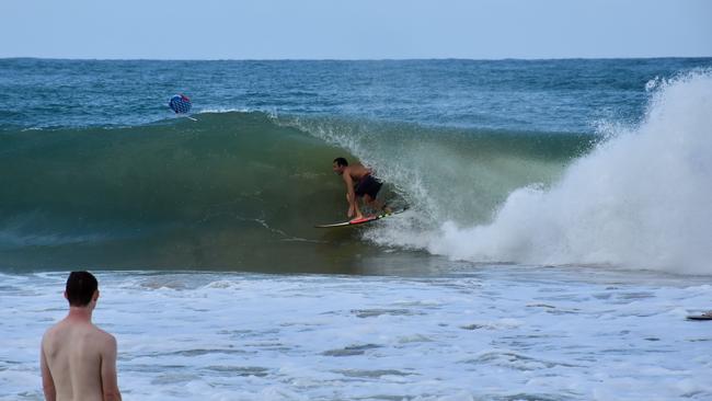
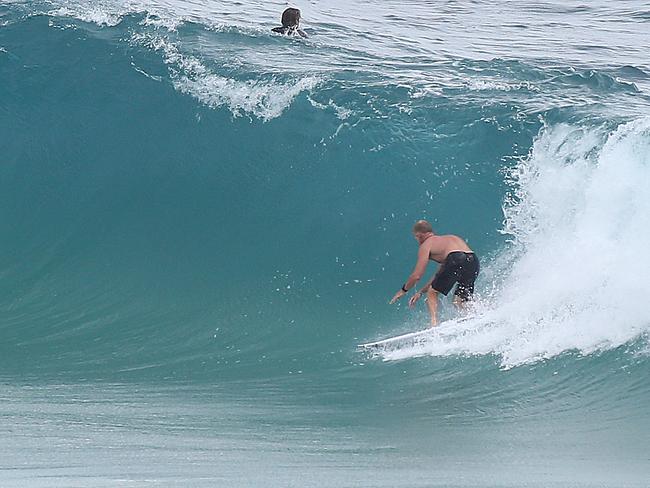
“We are seeing 2.5-3m surf off the Gold Coast so we are definitely urging swimmers to stay out of the water,” he said.
He said the “attitude of ‘she’ll be right’ won’t save your life in this kind of surf.”
“On Monday there is a King Tide along with this surf that is being pushed in so we will see a lot of water surging up and down the beach.”
“We will see a lot of water movement along Gold Coast beaches tomorrow with king and astronomical tides.”
He said the current surf conditions are “extremely dangerous”.
“Surfers and swimmers should leave it to the professionals because there is a good chance that if you don’t have much experience you will get yourself in trouble.”
QFES are currently monitoring the modelling of Tropical Cyclone Seth.
Seth, which formed on New Year’s Eve northeast of Mackay as a Category 2 cyclone, weakened to a Category 1 storm on Saturday but was forecast to re-intensify on Sunday as it tracked south before turning towards the coast.
Overnight, Seth started moving in a more southerly direction, but maintained Category 1 intensity.
On Monday, Seth is expected to weaken as it transitions into a subtropical system. The weather bureau says movement beyond that time becomes uncertain, however there is a general indication that it will drift westward closer to or over the Australian coast during the next week.
At 4am the bureau issued a severe weather warning for “abnormally high tides and dangerous surf” for people in parts of Wide Bay and Burnett and Southeast Coast districts.
Tropical Cyclone Seth is generating increasing seas and swell across southeastern Queensland, coinciding with an astronomical peak in high tides over the next few days.
Water levels on the high tide may exceed the highest astronomical tide (HAT) of the year by around 0.5m at some South East locations this morning, including the Brisbane area.
Tide levels are forecast to increase further on Monday and Tuesday, with many locations at risk of high tides greater than 0.5m above HAT. Conditions should begin to ease on Wednesday.
There is a separate hazardous surf warning current for the Sunshine and Fraser Island Coasts, which will extend into the Gold Coast waters on Sunday afternoon.
Waves of up to 5m and 20-30 knot winds were predicted to batter the coastline on Sunday.
A number of roads were cut by flash flooding overnight and the Rescue 500 helicopter was tasked to take a swiftwater rescue team to Rocksberg, east of Caboolture, after five vehicles were trapped by floodwaters. However, the water subsided after four hours and they were able to drive out safely.
The City of Gold Coast opened sandbagging stations and Mayor Tom Tate said his council was doing flood modelling on low-lying areas and preparing to activate the city’s Disaster Management Centre if Seth’s mood turned ugly.
“Mother Nature being unpredictable, Seth could turn and say hello to the Gold Coast and if that happens, we’ve got to brace ourselves for a cyclone,” he said.
He warned locals and tourists against venturing into the pounding surf, suggesting they should ‘go bowling’ or out to lunch instead.
“You can be a strong swimmer but it’s nasty out there,” he said.
“If the lifeguard says don’t do it, don’t get in the water. The surf is very risky.
“There’s wonderful restaurants open and there’s plenty of other things you can do.”
Beaches from Tallebudgera Creek to Southport on the Gold Coast and Coolum to Sunrise on the Sunshine Coast were closed on Saturday morning as the cyclone swell increased.
Surfers including former world champion Mick Fanning lapped up booming waves at protected point breaks such as Snapper Rocks and Noosa.
The Bureau of Meteorology warned that while Seth was not expected to directly impact the coastline in the coming days, it was would bring “dangerous surf” accompanied by king tides reaching a peak on the Sunshine Coast (2.08m) and Gold Coast (1.91m) on Monday and in Brisbane (2.79m) on Tuesday.
A severe weather warning has been issued for Fraser Island to Coolangatta.
“People should definitely not swim at closed beaches and exercise extreme caution on those that are open,” Surf Life Saving Queensland Gold Coast duty manager Brenden Scoffell said.
Emergency services were called to McNamara Rd at Rocksberg, east of Caboolture, just before midday to reports that multiple vehicles and at least five people were stranded by flood waters.
A Queensland Fire and Emergency Service spokeswoman said there were three points where the road crossed the Caboolture River and the cars had become “stuck between the first and second crossings”.
The Rescue 500 helicopter was tasked to take a swift water rescue team in to help the stranded motorists but the spokeswoman said nobody was injured or at risk.
“The plan at the moment is to wait for the water to recede as everyone is safe at this stage, uninjured and the river is stable,” she said.
After the motorists were left stranded for four hours, a QFES spokeswoman said the river had subsided by 4pm and all five vehicles were able to drive across safely.
The Gold Coast City Council has opened sandbagging stations across the coast.
These stations – at 232 Old Pacific Highway at Pimpama, 46 Boyd St at Tugun and 61 Hutchinson St at Burleigh Heads – will operate from 4.30pm-7pm on Saturday and 6am-10am and 3pm-7pm on Sunday.
More Coverage
Read related topics:Weather
Join the conversation

Feels like -5.3C: Icy blast sends temps plummeting again
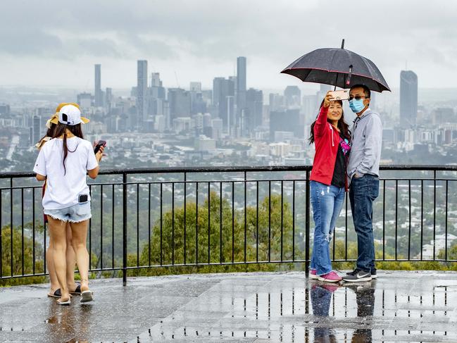
South East Queensland has again shivered through a freezing start to the day, as a brutal cold front continues to blast the region with subzero temperatures, made worse by chilling winds.
Read more

Feels like MINUS 7.1C: Brutal cold front blasts southern Qld
A brutal cold front is blasting across southern Queensland with subzero temperatures and widespread frost.
Read more