
More wild weather on the way after severe storms batter southeast
A house has caught fire after being struck by lightning, and thousands of properties have been blacked out as storms sweep the southeast for a second consecutive day. WATCH THE VIDEO
QLD weather news
Don't miss out on the headlines from QLD weather news. Followed categories will be added to My News.
A house on the Gold Coast has caught fire after being struck by lightning.
The house in Hanover Drive, Pimpama, was struck about 7.50pm on Wednesday.
Firefighters and paramedics attended, however no patients required treatment.
As of 9.15pm on Wednesday, nearly 4000 properties in southeast Queensland were without power after a second day of dangerous thunderstorms.
The majority were in Brisbane’s Woolloongabba, where 516 Energex customers were without power.
The traffic lights on Vulture St next to the Gabba were off in all directions.
Gympie Arterial Rd was partially closed due to flash flooding about 10.30pm. Motorists were reminded not to drive in floodwaters.
Storm activity flared up again late into the evening, with the Bureau of Meteorology issuing severe storm warnings for Maroochydore, Gympie, Caboolture, Noosa Heads, Cherbourg, Gayndah, Murgon and Nambour.
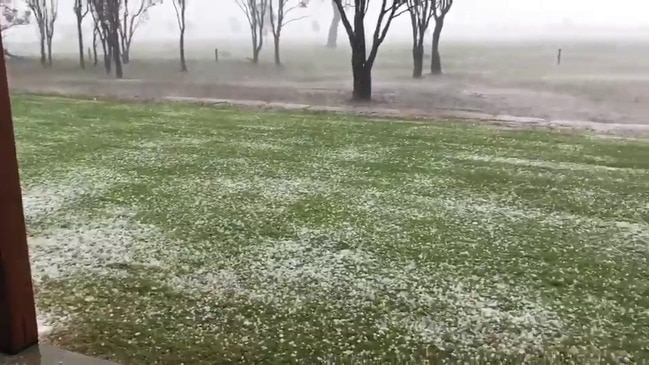
Large hail between 5-6 cm was reported just west of Toowoomba between 7.30pm and 8pm.
Some parts of southeast Queensland were hit by flash flooding and hail during the afternoon storms.
Seven severe thunderstorms were active across Queensland for much of the afternoon, with the Darling Downs town of Biddeston hardest hit.
About 2pm, the town west of Toowoomba was smashed by a wild hailstorm.

Biddeston woman Kate Cooke said hail rained down for around “10 to 15 minutes at lunchtime” leaving piles of it in the family’s backyard.
“My dog Lenny had a great time afterwards,” Ms Cooke said.
“We haven’t seen it like this for such a long time – very welcome rain that’s for sure.
“It was pretty exciting at the time. But felt bad for others who have harvest yet to do.”
Hail 4-5cm in size was also recorded in Banana and Proston.

Brisbane was hit by a second day of torrential rainfall while the Gold Coast recorded hail and heavy rain about 4.30pm.
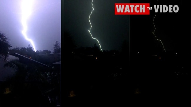
Thousands of lightning strikes were recorded across the region, with a stunning photograph from Hayley Clotworthy at Logan capturing how intense and potentially deadly some of the strikes have been.
Rainfall totals for today:
Cedar Vale – 74mm
Table Tops – 63mm
Home Park – 62mm
Magnolia – 51mm
Pomona – 43mm
Maroochydore 25-35mm
Northern Gold Coast – 20-30mm

Power was cut to more than 2000 homes and businesses across the Sunshine Coast according to Energex.
The outages included Beerwah, Booroobin, D’Aguilar, Kilcoy, Mt Kilcoy, Obi Obi, Peachester, Wamuran and Woodford.
Storm warnings are still active, with Toowoomba and surrounding areas in the firing line for damaging winds, large hail and heavy rain.
Earlier, severe thunderstorms were being tracked near Beenleigh, Cleveland, Rainbow Beach and the area south of Toowoomba.


Severe storms on the Sunshine Coast cut the power to more than 2000 homes and businesses surrounding the region.
According to Energex, the mass outages include Beerwah, Booroobin, D’Aguilar, Kilcoy, Mt Kilcoy, Obi Obi, Peachester, Wamuran and Woodford.
Beerwah and Kilcoy alone have more than 1000 outages between them.


At 3pm, the Bureau of Meteorology warned that six very dangerous thunderstorms were moving towards the east to southeast.
Severe thunderstorms are forecast to affect the ranges south of Gayndah and the area north of Lake Boondooma by 3.30pm and Proston, the area northwest of Murgon and the area northeast of Lake Boondooma by 4pm.

Other severe thunderstorms were detected on the weather radar near the area southwest of Caloundra, the area south of Gympie, Landsborough, Imbil, Kandanga, Amamoor and Jimboomba.
They are forecast to affect Caloundra, waters off Caloundra, the area southeast of Gympie, Pomona, Rainbow Beach and Inskip Point by 3.30pm and the area southwest of Noosa Heads, the area west of Noosa Heads, the area northwest of Noosa Heads, the area north of Noosa Heads, Lake Cooloola and Double Is Point by 4pm.
âš ï¸Severe Thunderstorm Warning - #SEQld updatedâš ï¸
— Bureau of Meteorology, Queensland (@BOM_Qld) October 28, 2020
A storm near #Proston is VERY DANGEROUS & may produce destructive winds >125km/h, large-giant hail & heavy rain/flash flooding. Several other severe cells reaching the coast now. Warnings: https://t.co/RdWw6dWORl pic.twitter.com/lSplGeket8
At 2.15pm, the Bureau of Meteorology warned of very dangerous thunderstorms near Kilcoy, northern Lake Wivenhoe, Somerset Dam, Lake Somerset and Mount Kilcoy.
“These thunderstorms are moving towards the east to southeast.
“Very dangerous thunderstorms are forecast to affect Caboolture, the area southwest of Caloundra, Peachester, Landsborough, Crohamhurst and Maleny by 2.40pm and Maroochydore, Caloundra, waters off Caloundra, waters off Maroochydore, waters off Bribie Island and northern Bribie Island by 3.10pm.
If you're in the path of this very dangerous storm, please seek shelter! Try and find somewhere undercover to park your vehicle, never under a tree, and wait it out. If you're at home, shut the windows and stay indoors until the storm has passed. #QldStorm #QldWeather https://t.co/B8tnelpkf2
— RACQ (@RACQOfficial) October 28, 2020
“Damaging, locally destructive winds, large, possibly giant hailstones and intense rainfall that may lead to dangerous and life-threatening flash flooding are likely.”
At 1.50pm, severe thunderstorms were detected on the weather radar near the area west of Esk, the area northwest of Esk, the area west of Kilcoy, Moore, Mount Kilcoy, Linville, the area south of Amberley and the ranges between Biggenden and Tiaro.
QLD Severe Thunderstorm Warning: Large Hail, Heavy Rain, Damaging Winds. Coolangatta, Burleigh, Coomera, Nerang, Beaudesert. #thunderstorm #ewnalerts #QLD #hail #wind #flood #qldstorm #qldwx #bnestorm pic.twitter.com/wv5BiBAPAf
— EWN Alerts (@EWNAlerts) October 28, 2020
“These thunderstorms are moving towards the east.
“They are forecast to affect Esk, Kilcoy, Crohamhurst, Maleny, Conondale and Montville by 2.20pm and Maroochydore, Logan City, Strathpine, Redcliffe, Caboolture and Caloundra by 2.50pm.
“Damaging winds, large hailstones and heavy rainfall that may lead to flash flooding are likely.”
At 1.20pm, severe thunderstorms were detected on the weather radar near the area south of Toowoomba, the area northeast of Kingaroy, Blackbutt, Yarraman, Murgon, Cherbourg and Toogoolawah.
âš ï¸ Severe Thunderstorm Warning - #SEQld updated âš ï¸
— Bureau of Meteorology, Queensland (@BOM_Qld) October 28, 2020
Severe thunderstorms are continuing to develop, and may produce damaging winds, large hail & heavy rain/flash flooding. Warnings and updates: https://t.co/ElyjBiW9A0 pic.twitter.com/dURg3C05Z7
“These thunderstorms are moving towards the east to southeast,” BOM warns.
“They are forecast to affect Kilcoy, the area west of Kilcoy, Lake Somerset, Mount Kilcoy, Linville and Elgin Vale by 1.50pm and Laidley, Gatton, Jimna, Mount Mee, Wamuran and Woodford by 2.20pm.”
Earlier at 12.15pm, the Bureau of Meteorology issued a severe thunderstorm warning for parts of Gympie and South Burnett council areas.
It warns that “severe thunderstorms were detected on the weather radar southwest of Mt Joseph.
“Thunderstorms are moving towards the southeast.
“They are forecast to affect the area north of Goomeri, the area south of Biggenden and the area north of Kilkivan by 1.15pm.
“Damaging winds, large hailstones and heavy rainfall that may lead to flash flooding are likely.”
Another more general warning was issued for the Wide Bay, Burnett, Darling Downs and Southeast Coast districts.
It warns that: "Severe thunderstorms are likely to produce damaging winds, large hailstones and heavy rainfall that may lead to flash flooding in the warning area over the next several hours. Locations which may be affected include Warwick, Toowoomba, Gympie, Kingaroy, Biloela, Calliope, Esk, Gatton, Gin Gin, Laidley, Mount Morgan and Nanango.”
.@BOM_Qld has warned thunderstorms are starting to develop across Wide Bay and Burnett and parts of Central Highlands and Coalfields, Capricornia, Darling Downs and Granite Belt and Southeast Coast Forecast Districts. Stay alert to changing conditions and stay safe Qld â›ˆï¸ pic.twitter.com/toxD77xmdG
— RACQ (@RACQOfficial) October 28, 2020
It comes after BOM this morning predicted that storms would hit Hervey Bay and the Sunshine Coast around midmorning before moving south towards Brisbane and the Gold Coast.
This major line of storms will then meet up with another system moving in from the south west, resulting in a long day of storms and potential flash flooding similar to scenes yesterday.
Queensland weather: Brisbane in firing line as supercells bring deluge across the southeast
Man seriously hurt, power out until Monday after storm chaos
“We’ve got another round of potentially significant storm activity in the southeast, further severe activity and high end severe again,” Bureau of Meteorology forecaster Felim Hanniffy said.
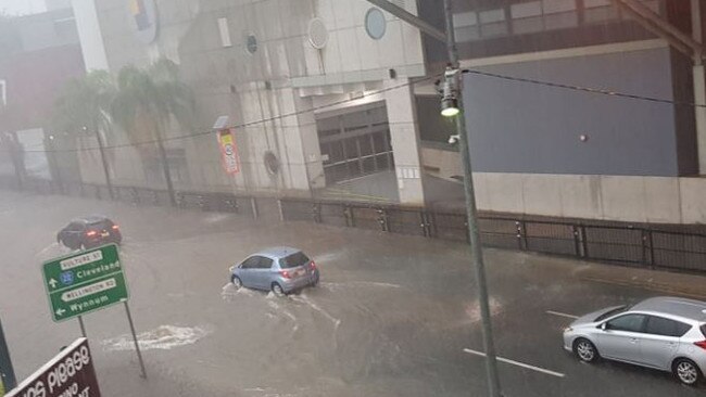
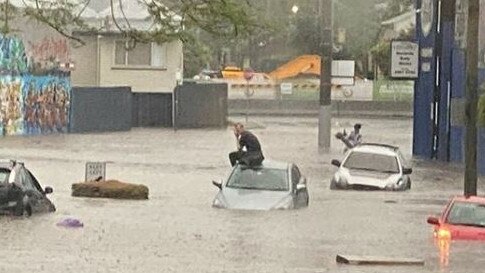
The wild weather yesterday flooded streets and train tracks, collapsed roofs and left thousands without power when a month’s worth of rain fell on southeastern Queensland leaving residents to mop up the mess.

At 11.30am, meteorologist Rosa Hoff told The Courier-Mail that giant hail could be a possibility today if conditions were intense enough.
“It does depend on individual storm development – a bigger storm can tend to lead to bigger hail but not always,” she said.
“It depends on what’s going on in the storm … In terms of storms today, if we did have a storm that got big and intense enough it could see some large hail, potentially even giant hail, because there are good conditions in the middle of the storm and the middle of the atmosphere to help that happen but it would depend on a storm getting big enough.”
RACQ revealed it had received 634 claims from home and vehicle damage caused by the storms in the southeast over the last few days.
The majority of yesterday’s 60 claims were from wind damage and leaking roofs.
Forecasters believe there is more where that came from after Brisbane copped its largest October downpour in 10 years.
A beloved Vietnamese restaurant in the heart of Wilston Village has been forced to temporarily close its doors following yesterday’s storm.
Ming Ming’s Kitchen on MacGregor Street took to Facebook to announce they won’t be able to serve customers after the extent of damage from heavy rainfall.
“Ming Ming’s Kitchen Wilston has suffered damages due to extreme weather, we won’t be able to operate until the problem is resolved.
“It is really sad not to go to work and serve our customers, we apologise for not be (sic) able to serve our favourite food. meanwhile, build your cravings and we will soon be back!”
Ming Ming’s Kitchen co-owner Tony Do said the ceilings of the restaurant will be assessed later today, which will determine when they can repair and reopen.

BOM Forecaster Peter Markworth revealed that while the past couple of days seems like a frantic start to Queensland’s storm season, we should be expecting more “burst” systems like this in the coming months.
“The storms we’ve been experiencing have resulted from one large low pressure trough through the west coming east” Mr Markworth told the Courier-Mail.
“While I’d say these type of systems aren’t rare, it does take some time for them to build up again.”

The destructive weather dumped 101mm of rain in a single hour at Beachmere, while The Upper Lockyer copped 70mm.
Hailstones the size of tennis balls battered Noosa and Gympie and severe storm warning is in place for the state’s southeast.
Sunshine Coast rail lines and Brisbane streets were flooded yesterday afternoon – cancelling trains and causing major congestion.
The “very dangerous storms” brought mini “twisters” to Warwick, and felled the roof of a unused commercial building in Moreton Bay.
There were also reports of large hail on the Sunshine Coast and flash-flooding in the Western Downs region, with the Bureau of Meteorology warning that the intense rainfall could lead to dangerous and life-threatening flash flooding.
Just under 70 calls were made to SES in Brisbane yesterday but the storms stretched right up to the coast. Train lines were suspended on the Sunshine Coast with parts of the coast receiving 81mm while Kullogum near Bundaberg had 70mm.
Forecaster Rosa Hoff said the storms had the ability to evolve rapidly and urged residents to heed weather warnings over the coming days.
“A severe thunderstorm is a thunderstorm which becomes so severe and so intense that it starts to develop severe weather of its own,” she said.
“We could see damaging winds in excess of 90km/h, large hail – which has a diameter larger than 2cm, so bigger than a $2 coin – or potentially even heavy rainfall which could lead to localised flash flooding.”

There were active warnings for most of southeast Queensland, including Brisbane, Logan, the Redlands, the Gold Coast and Sunshine Coast yesterday.
More than 80mm of rain was dumped on Caboolture in under an hour yesterday and another 75mm in the Upper Lockyer, with 57mm falling in less than 30 minutes.
In Fulham, more than 4300 Energex customers were left without power as a consequence of the severe weather.
TransLink suspended its Sunshine Coast train services between Eudlo and Mooloolah yesterday afternoon after rain flooded the tracks, and the RACQ urged motorists to drive safely and residents to tie down loose objects.
BoM predicted the storm activity would ease tomorrow and Friday, but could return by the weekend.
“Another system is going to roll in from the west on Saturday,” Mr Hanniffy said.
It comes as RACQ revealed they had received 458 insurance claims since Sunday’s destructive storms.
More than 100 claims have been for motor vehicle damage and 325 have been reported for damage to property.
Highest rain totals in the 24hrs to 10am Wednesday
Beachmere: 101mm
Toorbul (Donnybrook Road): 100mm
Radar Hillal: 81mm
Upper Lockyer: 77mm
Holland Park West: 66mm
Everton Hills: 49mm
