
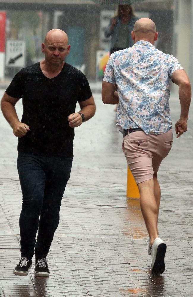
Man seriously hurt, power out until Monday after storm chaos
Some homes and businesses are expected to be without power until Monday after wild storms lashed southeast Queensland leaving trees down, homes and cars damaged and a man seriously hurt. VIDEO
QLD News
Don't miss out on the headlines from QLD News. Followed categories will be added to My News.
Households in parts of southeast Queensland may not have power restored until Monday after severe storms ripped through the region Sunday afternoon.
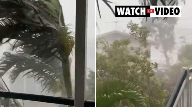
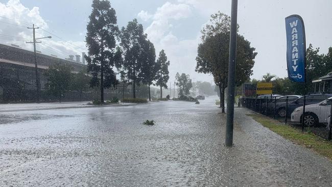
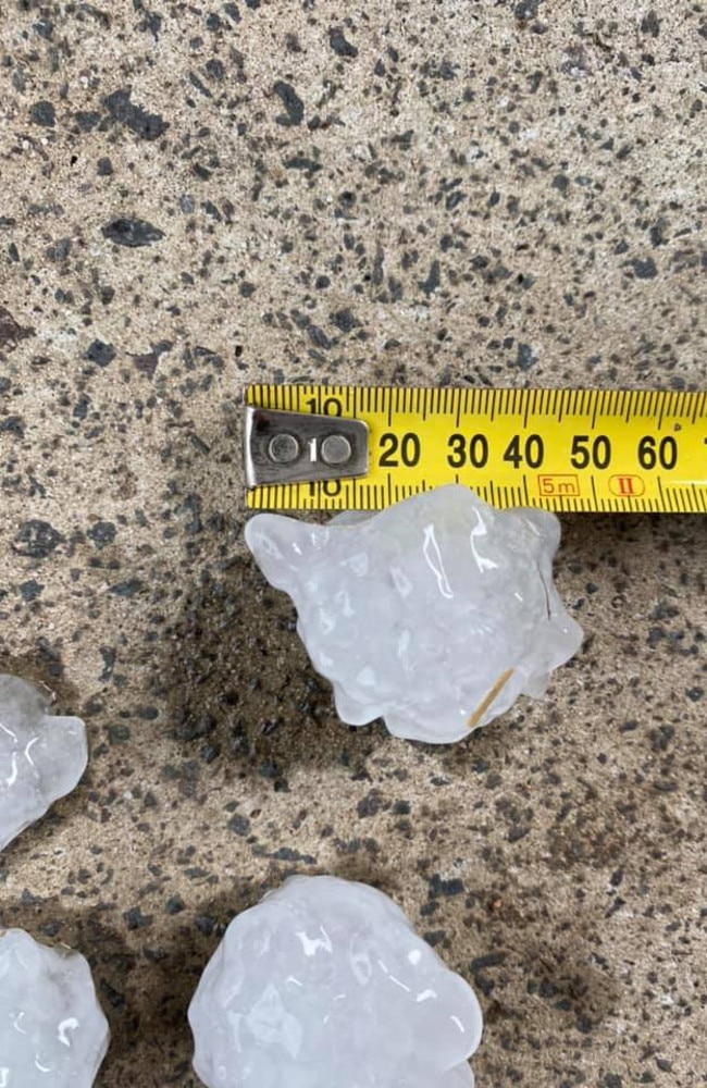
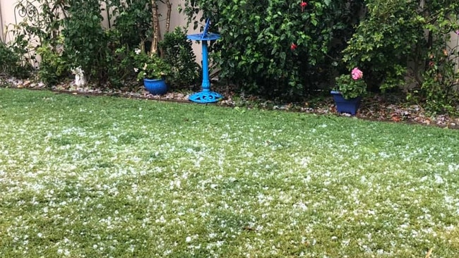
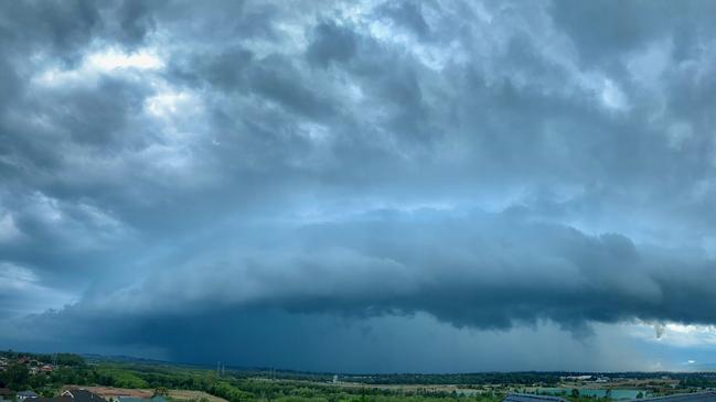
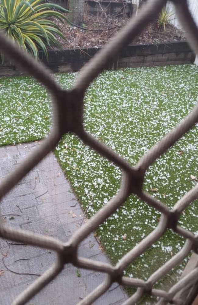
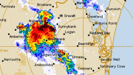
The supercell thunderstorms saw more than 80,000 lightning strikes recorded across the region through from midday to 4pm as well as wild winds, heavy rain and golf ball-sized hail.
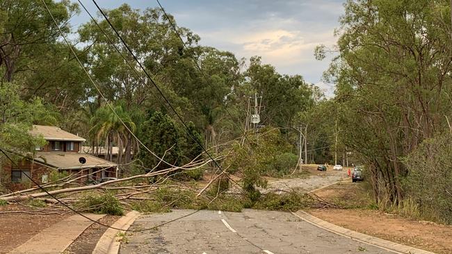
The wild weather saw more than 30,000 homes and businesses without power at 3.30pm, with those in the Redland City area most impacted (15,000 customers), followed by Ipswich (8700) and Brisbane (4700). Power had been restored to more than 5000 customers by 5pm but some were expected to be in the dark until Monday.
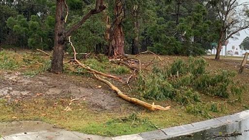
Our marvellous SES, RFS & FRS crews were very busy helping the community responding to more than 200 tasks today which included fallen trees, fallen powerlines & property damage.
— Qld Fire & Emergency (@QldFES) October 25, 2020
Take a look at these photos from just two of the jobs that happened around the State! pic.twitter.com/T9AswFHaT7
By 10pm there were still about 20,000 customers without power including 7855 in Redland City, 6635 in Ipswich and 4144 in Brisbane.
Energy Queensland – which runs the Energex and Ergon networks – said high winds and flying debris brought down 207 power lines in the southeast.
Powerlines were also brought down in the Bay Islands – of Russell, Lamb and Macleay islands.
“Damage to the network has been so significant that some customers in Redland Bay, Mt Crosby, the Bay Islands and surrounding areas – may not have power restored until possibly into tomorrow (Monday),” a statement said.
One man was left seriously injured after a tree fell on him in Ipswich.
Paramedics were called to the incident, off Hume Street in Karalee, about 1pm.
He had suffered head, shoulder and chest injuries when the tree fell on him at a private property.
The man, aged in his 30s, was taken to the Princess Alexandra hospital under lights and sirens in a serious but stable condition after being treated at the scene by critical care paramedics, the Queensland Ambulance Service spokeswoman said.
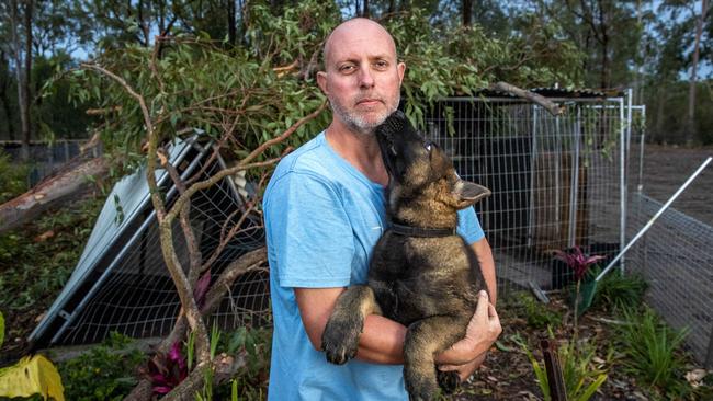
The man’s neighbour, father of two Matthew Steiler, was inside when he saw his neighbour trying to grab a trampoline that was being blown through his backyard.
Mr Steiler then saw a huge branch crush his kennel, which had two German Shepherd puppies inside.
He rushed out in the thick of the storm to get them out.
“I just heard screaming and I thought it might have been for the pup and that she was pinned, but she was okay,” Mr Steiler said.
The screams were coming from his neighbour’s wife after she saw the branch fall onto her husband.
“So I jumped the fence and his wife was already down there and she had seen it too because she was inside and I picked him up and got him inside the house,” Mr Steiler said.
“Paramedics couldn’t get through because there were trees down on the Warrego Highway apparently, the main ambulance couldn’t get here so we were waiting longer than we should have but that was no one’s fault.”
RACQ said it had 24 home and nine motor vehicle claims related to Sunday’s storms by 4.45pm.
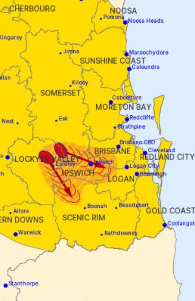
A storm warning from the Bureau of Meteorology, issued at 9.40pm said severe thunderstorms remained over the Lockery and Fassifern valleys.
“The Bureau of Meteorology warns that, at 9.30 pm, a cluster of severe thunderstorms were detected on the weather radar near Laidley, Gatton, Grantham, Rosevale, Mulgowie and Grandchester,” the warning said.
“These thunderstorms are moving towards the southeast. They are forecast to affect Harrisville by 10:00 pm.
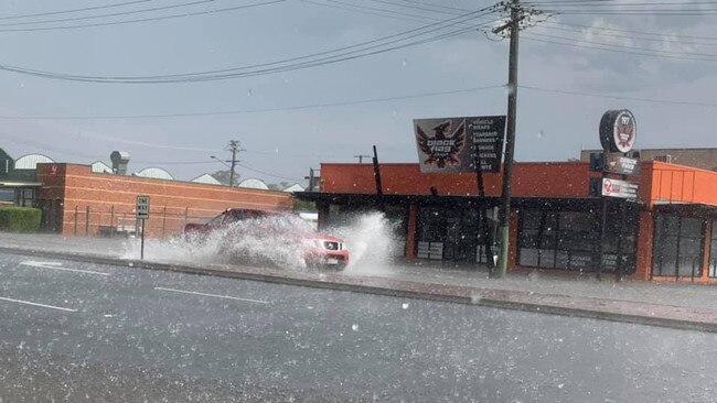
“Damaging winds and heavy rainfall that may lead to flash flooding are possible with these storms.”
Northgate resident Kerry O’Brien had earlier warned of flooded roads in Nundah and Northgate areas around 3pm.
“My rain gauge was measuring a rain rate of 155mm/hr which is a bit hectic,” Ms O’Briend said.
She also added there were “a few things thrown around the yard” and “a couple of cars in the street had water up pretty high”.
The State Emergency Service received reports of fallen powerlines and trees around the state’s southeast, including damage to power lines and roofs in Ipswich.
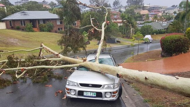
A car was crushed by a tree that fell in Mt Ommaney and a tree fell on a home at Runcorn after a reported lightning strike. Nobody was injured in those incidents.
“Golf-ball sized” hail stones have been reported near Ipswich and Acacia Ridge.
The Bureau of Meteorology reported hail up to 5cm in Oxley, hail about 4cm wide around Victoria Point and hail 3-4cm wide in the Mount Cotton area.
Wind gusts up to 93km/h were recorded at Brisbane Airport, with high winds causing damage to trees across several parts of the southeast.
Fallen trees are blocking the Brisbane Valley Hwy between Moombra and Wivenhoe Hill.
Severe storms are striking the south-east with lightning, giant hail, violent winds and torrential rain. @9NewsQueensland vision is amazing. Stay safe! We're live at the special time of five o'clock with the latest @9NewsQueensland @heinkealex @GarryYoungberry report #9NewsAt5 pic.twitter.com/1QlO7gnxlh
— Jonathan Uptin (@Jonathan_Uptin) October 25, 2020
Underwood residents were hit with a major blast of rain and wind which knocked out power lines on the corner of Logan and Springwood Rds just before 1.30pm.
Emergency crews were called to the area to turn off power and divert traffic around the intersection which was later closed.
Lightning hit a tree on the corner felling the powerlines.
Traffic was banking up about 2.30pm and could not turn from Logan Rd into Springwood Rd to join the M1 into Brisbane.
Drivers were diverted along a service road to Eight Miles Plains to get onto the M1 or told to head south to Springwood.
Energex crews were at the scene and it was expected there would be no power in that area for at least three hours.
Energex said there were 30,000 lighting strikes across the southeast since 12pm with 17,894 customers without power at 2.30pm.
Ipswich was the worst hit with 10,811 properties without power. There were 4835 properties without power in Brisbane and 1151 at Sunshine Coast.
There were 448 properties without power in Redlands and 395 in Logan still waiting for the power to return.
Energex said power was likely to be switched back on in the Brisbane region before 3pm.
A warning from the Bureau of Meteorology, issued at 6.08pm said severe thunderstorms were detected on the weather radar in the South Burnett region, moving towards the southeast.
“They are forecast to affect Lake Boondooma and the area south of Lake Boondooma by 6:35pm,” the warning said.
“Damaging winds, large hailstones and heavy rainfall that may lead to flash flooding are likely.”
An earlier warning, issued at 4.28pm, said severe thunderstorms in the southeast had temporarily eased.
“However, the redevelopment of severe thunderstorms remains likely. The situation is being closely monitored and further detailed warnings will be issued as necessary,” the warning said.
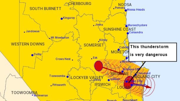
Before that, at 3.25pm, severe thunderstorms were detected near Cleveland, Kallangur, Boondall and Maroon Dam.
“These thunderstorms are moving towards the east. They are forecast to affect Redcliffe, Point Lookout and Mud Island by 3:55pm and Scarborough and waters off North Stradbroke Island by 4:25pm,” the warning said.
“Damaging winds, large hailstones and heavy rainfall that may lead to flash flooding are likely.”
A 3pm warning from the BoM was for severe thunderstorms that were detected on the weather radar near Cleveland, Nudgee, the area south of Cunninghams Gap and Rosevale at 3pm.
“These thunderstorms are moving towards the east. They are forecast to affect Boonah, southern waters of Moreton Bay and Mud Island by 3.30pm and the area between Boonah and Beaudesert, Point Lookout and Amity Point by 4pm,” the warning said.
“Large hailstones, damaging winds and heavy rainfall that may lead to flash flooding are likely.”
Earlier, the Bureau of Meteorology warned that storms were expected into the night after the first lot passed over the southeast at 1.35pm.
The thunderstorms affected Redland City islands including Macleay Island and there were high winds recorded at Victoria Point and at Point Lookout.
South Stradbroke Island also copped a beating.
“Other severe thunderstorms were detected on the weather radar near southern Lake Wivenhoe. “They are forecast to affect Mount Nebo and Highvale by 2:05pm and Brisbane CBD and Samford by 2:35pm.
“Damaging, locally destructive winds, large, possibly giant hailstones and heavy rainfall that may lead to flash flooding are likely.”
It comes after the Bureau of Meteorology issued a warning at 12.14pm for Ipswich and parts of Logan, Somerset, Scenic Rim, Lockyer Valley and Brisbane City Council areas.
“The Bureau of Meteorology warns that, at 12.10pm, severe thunderstorms were detected on the weather radar near Gatton,” BOM warns.
“These thunderstorms are moving towards the east to southeast.
“They are forecast to affect Laidley and Marburg by 12:40pm and Ipswich and Amberley by 1:10pm.
“Large hailstones, damaging winds and heavy rainfall that may lead to flash flooding are likely.”
It comes after large parts of Queensland were warned of dangerous thunderstorms producing large hail, damaging winds and flash flooding this afternoon.
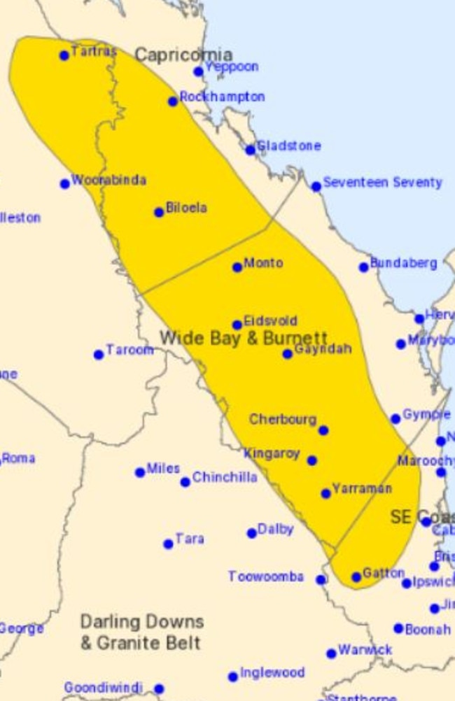
A severe storm warning was issued by the Bureau of Meteorology at 11am stretching from Gatton north to Yeppoon.
It warns that: “Severe thunderstorms are likely to produce large hailstones, heavy rainfall that may lead to flash flooding and damaging winds in the warning area over the next several hours.
“Locations which may be affected include Rockhampton, Kingaroy, Biloela, Gatton, Kilcoy, Laidley, Lowood, Mount Morgan and Nanango.”
It comes as Higgins Storm Chasing issues a warning for very dangerous supercell storms and severe storms this Tuesday.,
Higgins says “large to giant hail with damaging to destructive winds could cause extensive damage to homes and property”.
â›ˆï¸ Thunderstorm forecast for today (Sunday) ⛈ï¸
— Bureau of Meteorology, Queensland (@BOM_Qld) October 25, 2020
Severe storms likely for large parts of #Qld today. Large hail, damaging winds and heavy rainfall are possible with severe storm development. First warning about to be sent! For warnings: https://t.co/C2tHcOK6XT #QLDWeather pic.twitter.com/qkYyEAENAg
It comes after storms smashed through large parts of the southeast yesterday afternoon with 74mm of rain recorded in an hour in Brisbane’s south and residents warned of flash flooding.
Bureau of Meteorology forecaster Peter Markworth said the thunderstorms, which started about 1pm, brought heavy falls to pockets of Greater Brisbane, Moreton Bay and the Gold Coast.
A total of 92mm of rainfall was recorded in Camp Hill by 5pm yesterday, with a whopping 74mm falling between 3pm and 4pm. By 5pm, Carindale had recorded 53mm, Beachmere in Moreton Bay received 50mm, Benobble in the Gold Coast Hinterland took in 36mm, and 32mm of rain had hit Brisbane.
Mr Markworth said a new trough moving through western Queensland would bring a chance of showers and thunderstorms again from Sunday afternoon.
“It’s expected to be pretty active again (Sunday) from the afternoon,” he said.
Forecaster Rosa Hoff said it was possible the storms could be severe.
“We do have a possibility of severe thunderstorms over Brisbane, including the Gold Coast, Sunshine Coast, and that extends up to about Cairns where that is possible,” she said.
“(Severe thunderstorms) are more likely around the Central Highlands and Coalfields.”
Brisbane reached a top of 27C yesterday but temperatures were expected to be slightly above average across today.
Brisbane is forecast to reach a maximum temperature of 29C today and tomorrow.
There is a high chance of showers continuing in Brisbane through until the middle of next week.
WHERE IT FELL (Saturday)
Brisbane area
Camp Hill – 99mm
Carbrook (Riedel Rd) – 60mm
Beachmere (Riversleigh Rd) – 56mm
Carindale – 56mm
Burbank – 53mm
Mansfield – 52mm
Chandler Bacton Rd – 41mm
Rose Creek Rd – 43mm
Caboolture (Pumicestone Road) – 40mm
Redcliffe – 37mm
Strathpine (Gympie Rd) – 33mm
Rothwell – 32mm
Sunshine Coast
Beachmere (St Smith Rd) – 48
Coolabine Creek – 43mm
Meridian Way – 40mm
West Woombye – 39
Moy Pocket – 38mm
Gold Coast
Flagstone Ck (Jimboomba) – 48mm
Forest Lake (Rachele Cl) – 47mm
Benobble 41mm
Bromfleet – 36mm