
Monsoon in the north, thunderstorms to the south: QLD set for a wet second half to the week
Queensland could be in line for its second cyclone in less than a month with heavy rain expected to kick off as early as tomorrow in communities smashed by ex-tropical cyclone Jasper.
QLD weather news
Don't miss out on the headlines from QLD weather news. Followed categories will be added to My News.
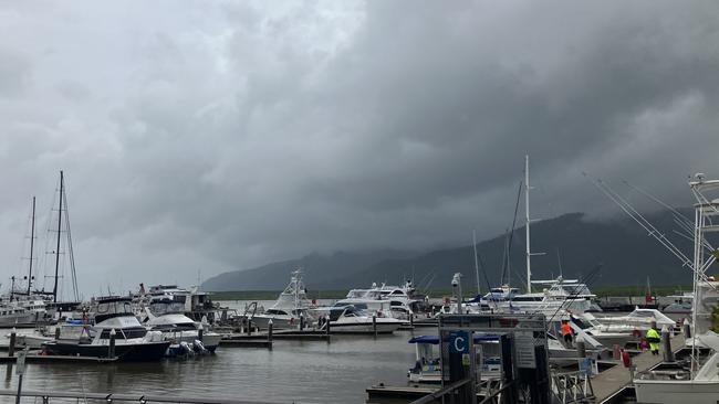
A tropical cyclone could be on the cards for residents in Far North Queensland less than a month after ex-cyclone Jasper brought destructive flooding to parts of Cairns, Port Douglas and other areas in the Douglas Shire.
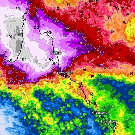
A developing monsoon trough in the north is expected to bring heavy rain and potential thunderstorms to regions still recovering from Jasper.
The Bureau of Meteorology’s Daniel Hayes said the monsoon trough was expected to develop over the Northern Territory and into the Gulf of Carpentaria from Thursday, bringing heavy rainfall to already sodden areas.
Totals of up to 500mm are forecast by some weather models.
If a tropical low develops over water over the next few days, there is a 25 per cent chance it will intensify into a cyclone.
Mr Hayes said up to three lows could develop off the monsoon trough over the next four days.
The first tropical low would most likely develop along the monsoon trough line tomorrow in the Joseph Bonaparte Gulf, or over land across the western parts of the Northern Territory.
“As we head into Saturday, if that low 03U forms over water, there’s about a 25 per cent, moderate chance it would intensify to become a cyclone,” Mr Hayes said.
“That (cyclone development) possibility continues into early next week before conditions weaken.”
If a tropical low and cyclone do not form, there is further chance a separate tropical low will form closer to Queensland in the Gulf of Carpentaria along the same monsoon trough line -bringing yet another risk of cyclone development.
“As we head into the early part of next week the system near the Gulf has a low chance of developing into a cyclone,” Mr Hayes said.
“It may linger in the Gulf. There is some chance it can move across the Cape and into the Coral Sea, but again, nothing has been confirmed yet, so quite a lot of uncertainty.
There is also a third possibility of a low forming out near Cocos (Keeling) Island, west of Christmas Island in the Indian Ocean, which is in the Australian area of Responsibility. but Mr Hayes said there was currently minimal threat to the mainland due to distance.
In the meantime shower activity will continue across the top end of the Northern Territory and northern Queensland tropics, bringing some welcome heat relief for residents.
Mr Hayes said the northern rains were typical of this time of year and showed a “fairly late” onset to the monsoon season.
“We are most likely going to see significant rainfall in the coming days for areas affected by Cyclone Jasper.
“Right across the Gulf of Carpentaria and to the north coast there will be increasing shower and storm activity from as early as tomorrow,” Mr Hayes said.
Amateur weather forecast Facebook page Tim’s Severe Weather has declared that the “north Australian monsoon is going to explode over the next few weeks”.
“With the development of several tropical rain-bearing systems and even a cyclone or 2 thrown into the chaos!”
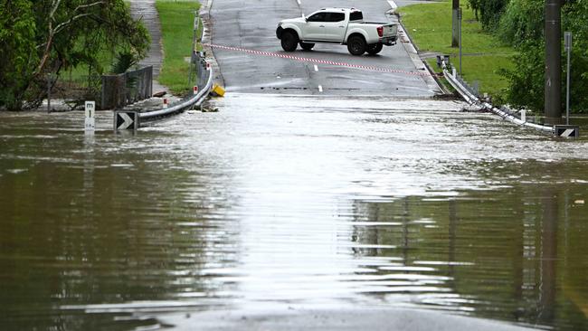
The entire state is bracing for a wet and wild end to the week, with a forecast for showers and thunderstorms that could bring heavy rainfall.
This comes as slow-moving storms hit the state all day on Tuesday, with more than 130mm dumped in three hours in some areas.
Mr Hayes said there was the risk of thunderstorms for a broad area across Queensland, with isolated cells lending to the possibility of significant rainfall.
“The main hazard again will be heavy rainfall. It is really the Southern Downs, Granite Belt and southern parts of the Gold Coast hinterland that we are keeping an eye on today for those severe storms,” Mr Hayes said.
On Tuesday several parts of the state copped a drenching including 136mm in Claraville in the Gulf Country and 118mm in Wondoola.
Storms through the southeast brought 136mm to Springfield Lakes, 123mm to Nerang Dam and 106mm to Jingle Downs.
“On Tuesday we saw individual thunderstorm cells dumping large amounts of rain to isolated areas in the southeast, as well as some bigger falls in the Central West and Warrego Area,” Mr Hayes said.
“[Wednesday] we’re looking at almost the entire state see the possibility for thunderstorm activity, with potentially severe storms tracking through those southern parts.”
The inland trough bringing the shower and storm cells will continue to have influence into Thursday and Friday, with a chance of thunderstorm activity remaining along the coastal areas into the weekend.
“There will be a bit of an easing in conditions for the southern parts of the state, however shower activity will continue right through to the weekend with the potential for heavier falls weakening.”

Why is it so cold? What about these winds? Your Qld weather questions answered
Multiple flights have been cancelled and temperatures have plummeted – so what does it all mean for Qld?

Strong winds, freezing temps as ‘cyclone bomb’ delivers parting shot
Wild winds have continued to smash South East Queensland, as icy blasts from the “cyclone bomb” hitting NSW and forcing the cancellation of multiple flights deliver more knock-on effects in the Sunshine State.