
Brisbane weather: Storm warning cancelled after intense rainfall, flash flooding
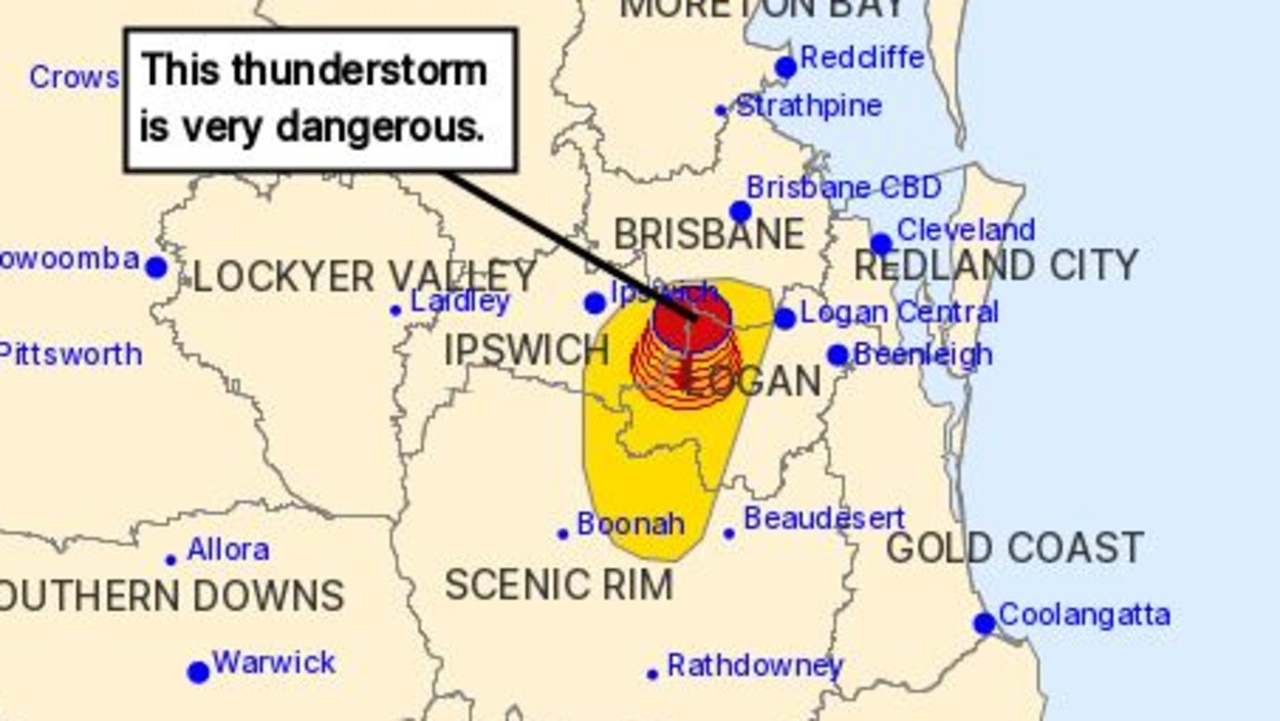
A severe thunderstorm warning issued for parts of the state’s South East on Tuesday night has been cancelled after parts of the state were hit with up to 113mm of rain.
QLD weather news
Don't miss out on the headlines from QLD weather news. Followed categories will be added to My News.
A severe thunderstorm warning issued for parts of the state’s southeast on Tuesday night has been cancelled.
The Bureau of Meteorology said the severe storms are no longer affecting the South-East Queensland area, east of Dalby from Rainbow Beach to Stanthorpe.
The immediate threat of severe thunderstorms has passed, but the situation will continue to be monitored and further warnings will be issued if necessary, the Bureau said.
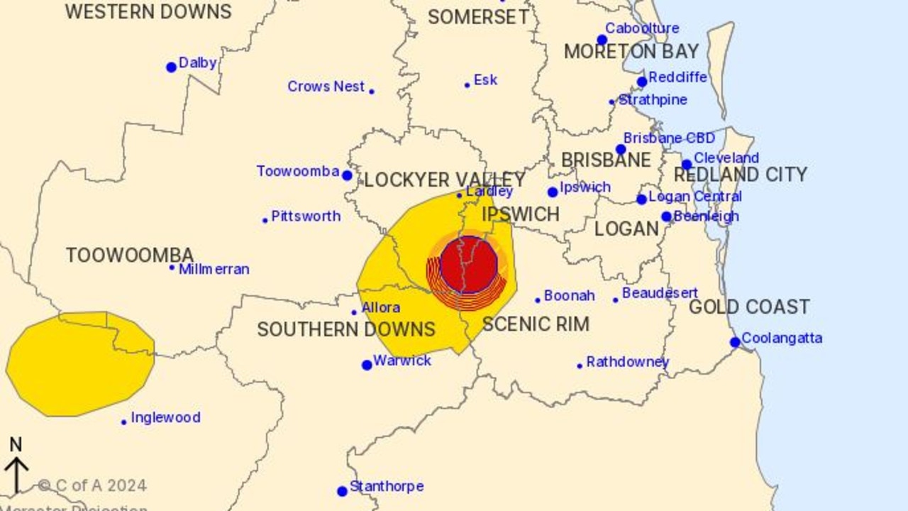
A more general severe thunderstorm warning remains for people in parts of Maranoa and Warrego and Darling Downs and Granite Belt forecast districts.
Severe thunderstorms are likely to produce heavy rainfall that may lead to flash flooding in the warning area over the next several hours.
Locations which may be affected include Dirranbandi and Tara.
Severe thunderstorms are no longer occurring in the Northern Goldfields and Upper Flinders, Central Coast and Whitsundays, Central Highlands and Coalfields, Central West and Southeast Coast districts and the warning for these districts is cancelled, the Bureau said.
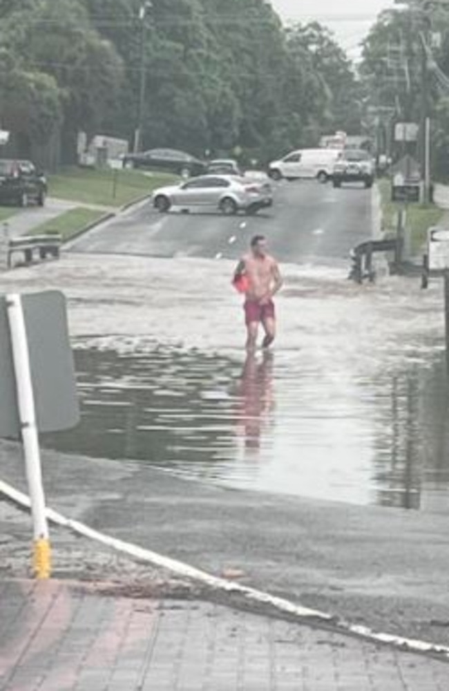
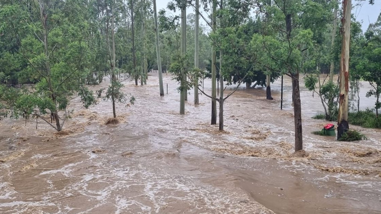
Slow-moving storms have hit the state all day, with more than 130mm dumped in three hours.
Springfield Lakes recorded 131mm in the three hours to 7am.
The Jingle Downs alert in Logan copped 83mm in the two hours to 7am.
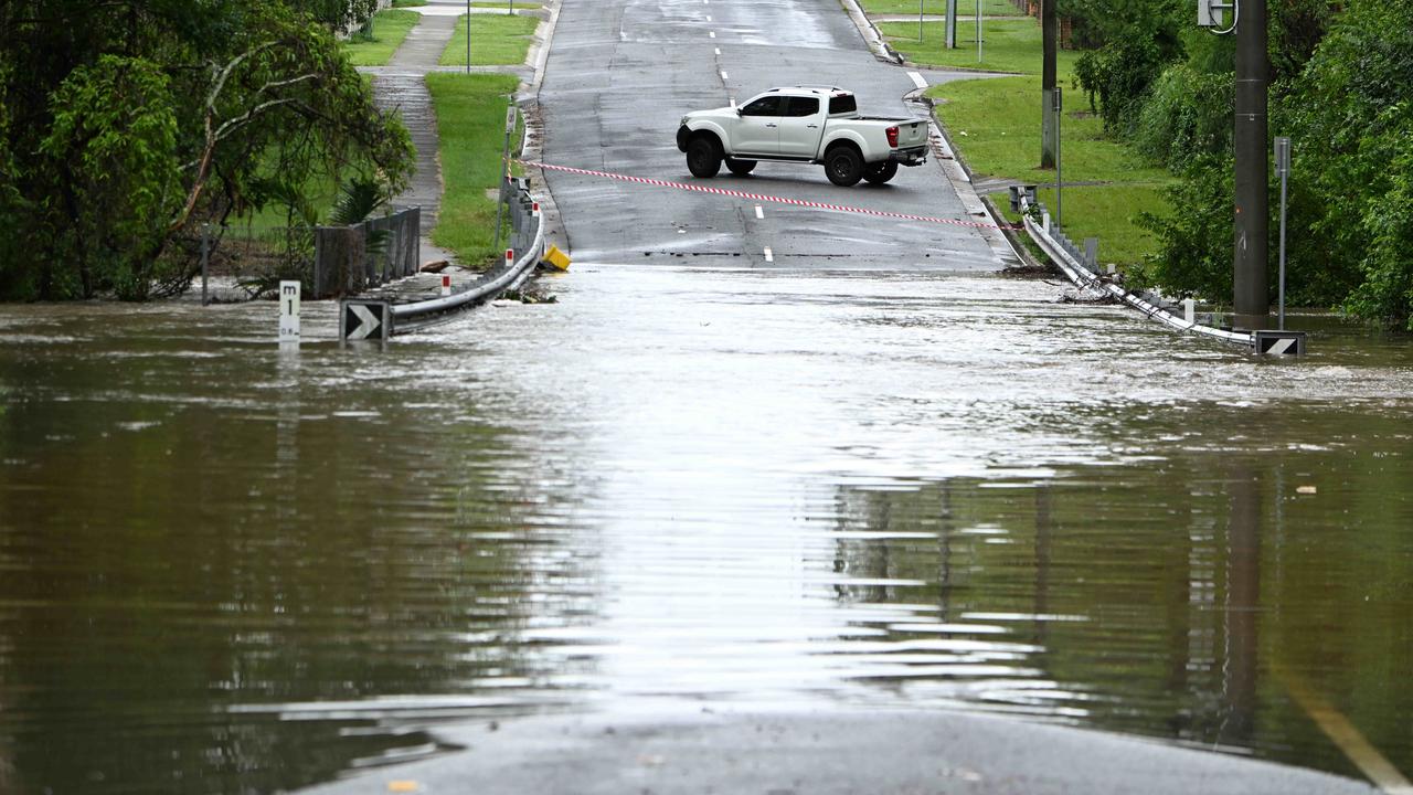
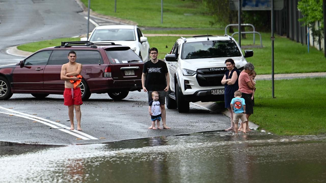
Roads in the areas were affected.
The morning storm moved south before petering out, with the Bureau downgrading the threat just after 8am. However, it warned severe storms could redevelop.
It comes as Federal Emergency Management Minister Murray Watt has denied the Bureau of Meteorology “got it wrong” when it forecast a hot and dry summer due to the El Nino weather pattern, as Queensland continues to mop up from devastating storms and floods.
The bureau declared an El Nino event in September but the Sunshine State has been lashed by storms and heavy rain over the past month, including Ex-Tropical Cyclone Jasper and the Christmas night “tornado” which unleashed widespread destruction on the Gold Coast.
Speaking alongside Prime Minister Anthony Albanese at the Gold Coast’s Disaster Emergency Management Centre on Tuesday, Senator Watt defended the BOM.
“The short answer is no,” he said when asked if the bureau had got it wrong.
“The Bureau of Meteorology’s forecast that we were heading into an El Nino was correct and remains correct. The issue is that just because we have an El Nino doesn’t mean that you don’t get heavy rain in the meantime.
“It is not all unusual to see heavy rain in some parts of the country to see heavy rain during an El Nino cycle, and unfortunately that’s what we’re seeing happen right now.”
Tuesdays rainfall follows a wet Monday, when many areas across the state copped a drenching, bringing over 100mm of rain and flash flooding.
Meteorologist Angus Hines had Tuesday morning said there would be similar conditions in parts of the southeast, central-west and northern Queensland today.
“It was certainly a wet day across much of Queensland on Monday with significant rainfall totals and thunderstorm activity,” Mr Hines said.
“A band of rain and storms which brought pockets of heavy rain across the state on Monday and Monday night has remained on Tuesday.
“Currently the trough is tucked inland, to the west of the major metro areas and that is particularly where we are going to see the slightly heavier rainfall.”
High moisture levels and humidity will continue into Wednesday and Thursday, lending itself to the chance of more showers and thunderstorms.
“There is a fairly broad thunderstorm risk for the next few days, but we are seeing a gradual easing trend as the week moves forward.”
The largest accumulation of rainfall in the state on Monday was in Sandra Downs in the Central Goldfields District, with 160mm of rain recorded since 9am on Monday.
“The central and western areas had pockets of heavy accumulation of around 80-90mm, around the northern Goldfields and southwest of Townsville.”
This comes after 115mm of rain fell at Charleville on Sunday, causing localised flooding.
The southeast also recorded heavy rainfall and experienced localised flash flooding, including 141mm at Clagiraba Road northwest of the Gold Coast since 9am Monday.
“The biggest rainfall in the southeast fell just inland from the Gold Coast where a few weather stations got over 100mm of rain since 9am Monday,” Mr Hines added.
“There was also 50-75mm of rain in places southwest of Brisbane and 40mm in the northern suburbs.”
Other notable rainfall totals included 131mm at Tomewin, 120mm at Little Nerang Dam, 68mm in Dalmeny, 64mm in Miva and 53mm in Oxley Creek.
On Monday night a car was swept away in flash flooding following a sudden storm deluge in Petrie, in the Moreton region, leaving the driver and passenger clinging to the side of their vehicle.
Multiple roads in the Gold Coast region remain closed this morning due to flash flooding including roads in Mudgeeraba, Wongawallan, Guanaba and Canungra.


Ice ice baby: Spectacular images of unseasonal frost as Qld freezes
Queensland’s overnight temperatures will increase to double digits in the coming days, following the coldest start to winter in 16 years, bringing frost and ice to many regions. SEE THE PHOTOS

City’s coldest June start in 16 years, feels like MINUS 9.8C out west
Southeast Queensland is shivering through its coldest morning in more than 15 years but feels-like temperatures have dropped to insane levels in the southern inland.