
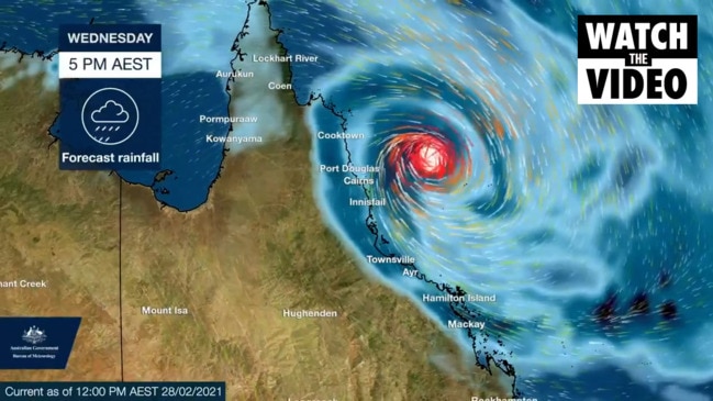
Heavy rainfall, strong winds in north as cyclone expected
A tropical low expected to turn into a Category 3 cyclone is creating wind gusts up to 95kmh, with trees and powerlines down in the Far North.
QLD weather news
Don't miss out on the headlines from QLD weather news. Followed categories will be added to My News.
A tropical low expected to turn into a cyclone on Tuesday is now less than 100km off the Queensland coast and creating wind gusts up to 95kmh.
The Bureau of Meteorology issued an updated cyclone warning for the Far North at 5pm, with the system expected to eventually become a Category 3 cyclone.
The update comes after Townsville Mayor Jenny Hill slammed the Bureau of Meteorology after the Townsville radar went offline.
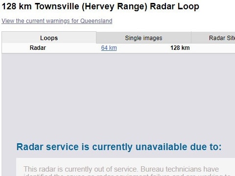
The radar is expected to be out for days, with Cr Hill saying it’s “not good enough” that residents are unable to track the potentially dangerous weather system properly.
SCROLL DOWN TO READ MAYOR HILL’S FULL RESPONSE
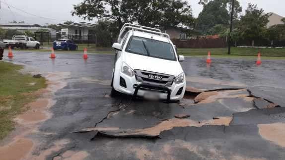
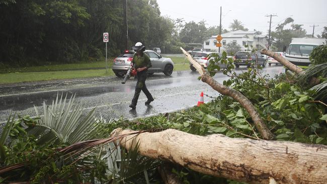
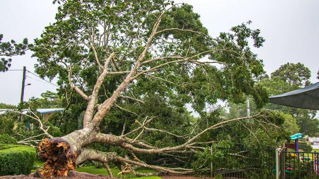
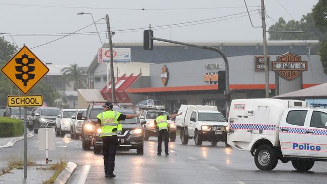
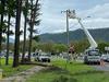
More than 42,000 homes were without power across the Far North at 5pm and power lines and trees were down in multiple locations, forcing the closure of some roads including Gillies Range.
Ergon had crews responding but customers were urged to show patience as weather hampers restoration efforts.
The outages spread from Kuranda, across Cairns, out to the Tablelands and south to Tully.
More than 40 roads were closed at 3.30pm, as were several council facilities.
Several schools across the Far North were closed today due to flooding and the Cairns Catholic Education Diocese of Cairns confirmed that all Far North Catholic schools except for a few on the Cape would be closed Tuesday.
A number of public schools have also been closed.
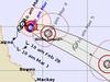
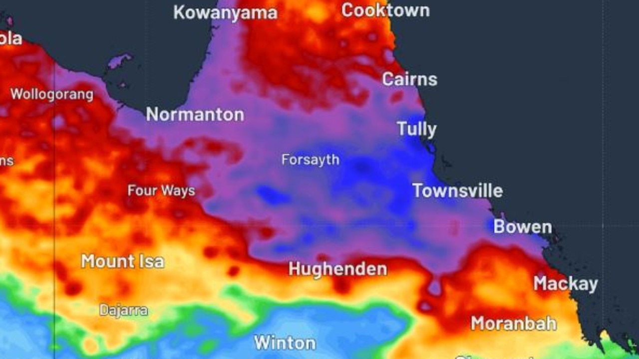
The topical low was 95km east-northeast of Cairns and 110km north northeast of Innisfail at 5pm, blowing sustained winds near the centre of 65km/h with wind gusts to 95km/h.
The low was moving west at a rate of 14km/h.
A tropical low is developing near the north tropical coast of Queensland. https://t.co/rVLE6i5J4y pic.twitter.com/EZnGfRyBCZ
— Bureau of Meteorology, Queensland (@BOM_Qld) March 1, 2021
“The tropical low is slowly moving northwards but is expected to become slow-moving from tonight or early on Tuesday,” BOM said in a statement.
“The low is expected to gradually intensify to tropical cyclone strength during Tuesday.
“Coastal crossing is not expected, however the system is likely to continue to cause gales about the coastal and island communities tonight and on Tuesday.
“While coastal crossing is not expected, the system is likely to cause gales about the coastal and island communities.
“The cyclone is likely to remain slow-moving off the North Tropical Coast while intensifying over the next two days. In the longer term, it is likely to take a south-easterly track away from the coast as a Category 3 cyclone.”
Gales with gusts to 100km/h are likely about the coastal and island communities between Cape Flattery and Lucinda, including Cairns and Innisfail, during today and on Tuesday.
Heavy rainfall is likely about the coastal and island communities between Cape Flattery and Lucinda, including Cairns and Innisfail, tonight and on Tuesday.
A flood watch is current for the north tropical coast between Mission Beach and Rollingstone; refer to that product for more information.
Abnormally high tides and large waves may cause flooding near the foreshore.
People likely to be affected should take measures to protect their property as much as possible and be prepared to help their neighbours.
An emergency alert was earlier issued for Palm Island as the Aboriginal community experiences gale force winds.
The Local Disaster Management Group has issued a warning for gale force winds and heavy rain, which are now affecting the island and are expected to continue into Tuesday.
Residents of Palm Island have been warned to cancel all non-essential travel, secure their premises, find a safe place to shelter and stay home.
Significantly high tides were causing heavy rainfall Monday morning.
“Although a direct coastal impact is not expected, gales are possible about exposed coastal and island areas as the system reaches cyclone strength. Heavy rainfall is also likely,” the forecast said at the time.
“While there remains a range of possible scenarios, a direct coastal crossing is unlikely with the system most likely to meander off the coast for a few days and then track quickly southeast by the end of the week.
Flood watches are in place for a stretch of the north Queensland coast.
“We will see the heaviest from probably Innisfail to Ingham coast over the next 24 hours but it all depends on where the tropical low goes as to where the worst of the rain hits,” a Bureau of Meteorology spokesman said Monday morning.
“People living in areas likely to be affected by this flooding should take measures to protect their property as much as possible and be prepared to help their neighbours.”
A stretch of the north Queensland coast, from Cooktown down to Lucinda, is expected to be slammed on Tuesday morning by wind gusts of up to 100 km/h.
Wind gusts of more than 80km/h were recorded along the Cassowary Coast Monday morning.
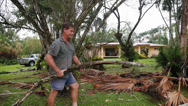
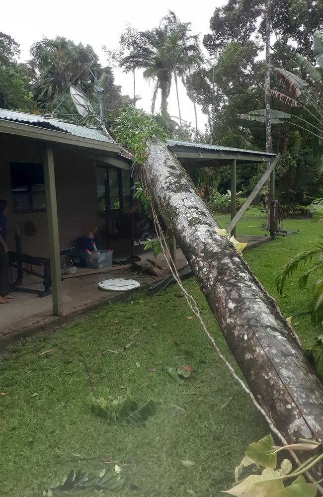
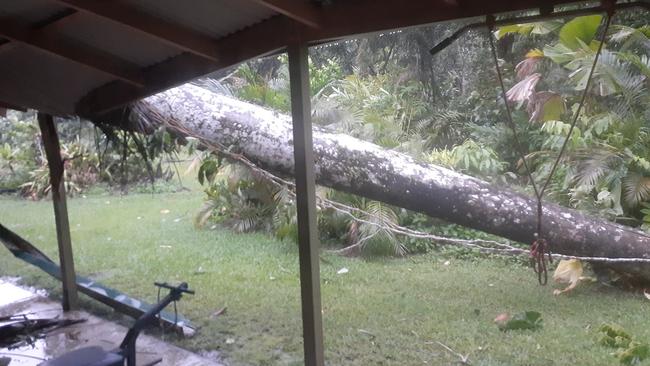
A Bellenden Ker family said it felt like their home was being “taken by a cyclone” as wild weather caused a huge palm tree to crash onto their home in the middle of the night.
Craig Barelds said the family was woken by the “biggest bang” about 2am on Monday morning to find the giant tree had landed on their roof just above his 10-year-old son’s bedroom.
Mr Barelds said the tree had survived multiple major weather events, but had likely caused more than $10,000 to their home as it crashed onto the tin roof, through the gutter and support beams.
“We’d just had some trees removed too, but not that one,” he said.
MAYOR SLAMS BOM OVER RADAR GLITCH
The BoM’s Townsville radar will be offline during this time due to a technical fault and is set to be sidelined for several days.
Townsville Mayor Jenny Hill has lashed out at the Bureau of Meteorology over the radar fault, which makes it difficult for Townsville residents to keep track of the tropical low’s movements.
BOM had suggested the Townsville community rely on the Bowen and Cairns radars, but zoomed out, but Cr Hill said this was not good enough.

“The radar can provide information about what is actually happening in the precinct,” Cr Hill said.
“We have a cyclone brewing that could get up to category two, possibly three by Thursday.
“Quite frankly, it’s not good enough that we’re not seeing the investment in the Bureau.
“The Bureau has been set up by the federal government not just to tell it’s going to be a nice day, but particularly in North Queensland around disaster management and mapping.”
BOM told the Townsville Bulletin technicians had visited the radar and diagnosed the fault that caused it to go offline.
“It will need parts sent from interstate,” a BOM spokeswoman said.
“Radar control components and components that process radar signals need to be replaced.”
The spokeswoman said technicians from the Cairns Observations Operations Hub were onsite shortly after the radar went down, but Cr Hill said this was also an issue.
“To have service technicians only available in Cairns and Brisbane, can I say, is a bloody big stretch,” Cr Hill said.
“This state is nearly three times the size of Victoria, when radars go out or there are problems with sensors, you’ve got to depend on someone from Brisbane or Cairns driving up to fix it for flying up.
“When you’ve got inclement weather, how the hell are they going to get up here.
“We’re very lucky at the moment that the rains haven’t really pushed past the coast and cut off road access.”
STORMS EXPECTED TO HIT STATE’S SOUTH
Storms were expected to set in for parts of the southeast on Monday afternoon as the first week of Autumn brings cooler temperatures across the region.
The southeastern interior was expected to see possible severe thunderstorms, Bureau of Meteorology forecaster Shane Kennedy said on Monday morning.
“Showers and thunderstorms are increasing in the southeast today, with the risk of severe thunderstorms in the southeastern interior today and tomorrow,” he said.
Mr Kennedy said the storms would ease to showers on Thursday after a drop in temperatures on Wednesday.
“Cooler temperatures are expected in the southeast from Wednesday, as a south-easterly change arrives.”
Brisbane is forecast to reach up to 29C on Wednesday, with temperatures dropping to a high of 27C by Saturday.
On the Gold and Sunshine Coasts temperatures are expected to drop to 26C by the end of the week.
More Coverage
⛈ï¸Today's thunderstorm forecast: severe thunderstorms likely around Hinchinbrook and Palm Island and possible around the northeast due to the developing low. Possible severe thunderstorms also over the Peninsula and the south eastern interior. Warnings: https://t.co/IQm7cbTXFypic.twitter.com/tuWOXP7sAW
— Bureau of Meteorology, Queensland (@BOM_Qld) March 1, 2021
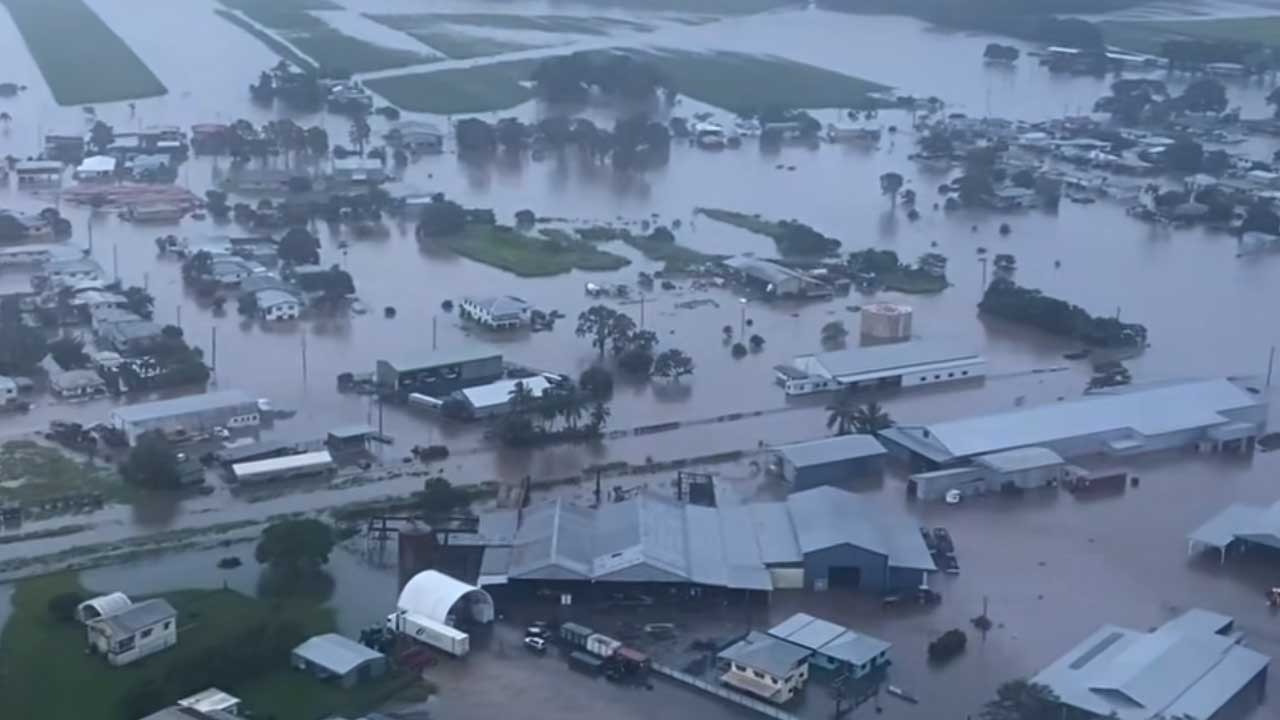
Hell and high water: Inside ground zero of North Qld’s flood nightmare
In the dead of night, as most of Ingham slept, a torrent descended. Nothing will ever be the same again. This is the untold true story of how the North Qld spirit conquered unimaginable tragedy and heartbreak.
Tiny town braced for biggest flood in 30 years, set to cut off Bruce Hwy
Residents in a small town southeast of Townsville are braced for its biggest flood in three decades with the region facing another 500mm deluge that’s set to cut off the Bruce Highway.