
FNQ weather: Tropical Cyclone Lincoln makes landfall on Qld coast
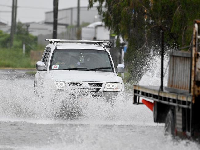
The third Tropical Cyclone of the summer has made landfall on the Queensland coast triggering severe weather warnings for heavy rain and damaging winds.

QLD weather news
Don't miss out on the headlines from QLD weather news. Followed categories will be added to My News.
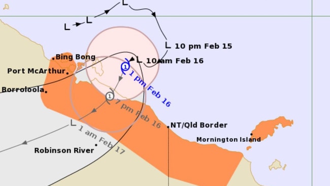
Tropical Cyclone Lincoln has made landfall on the north west Queensland coast with a severe weather warning in place for heavy rainfall and damaging winds.
The Bureau of Meteorology has downgraded its warning for Tropical Cyclone Lincoln making landfall in the southern Gulf Carpentaria this afternoon.
The warning initially said the cyclone would have damaging wind gusts of up to 110km/h but has now downgraded to 90km/h with wind speeds of 50 to 60 km/h.
A severe weather warning for heavy rainfall and damaging winds remains in place for the western Gulf Country.
A flood warning is also in place for areas including Mornington Island, Doomadgee, Burketown, Augustus Downs Station, Westmoreland Station and Lawn Hill.
Emergency services have advised people to their park cars undercover and away from trees, close doors and windows, keep pets safe, not to drive and to keep up to date with alerts.
Earlier, the bureau’s Angus Hines said Tropical Cyclone Lincoln would make its way onshore in the next six to 12 hours.
“It’s only going to be a short lived cyclone though, later on Friday afternoon around 4pm or 5pm Northern Territory time. We are expecting this tropical cyclone to cross over the coastline and start to make its way onto the land,” Mr Hines said.
“Through the course of the weekend it is going to work on a westward trajectory across the Territory bringing some areas of quite heavy rain through these central areas.”
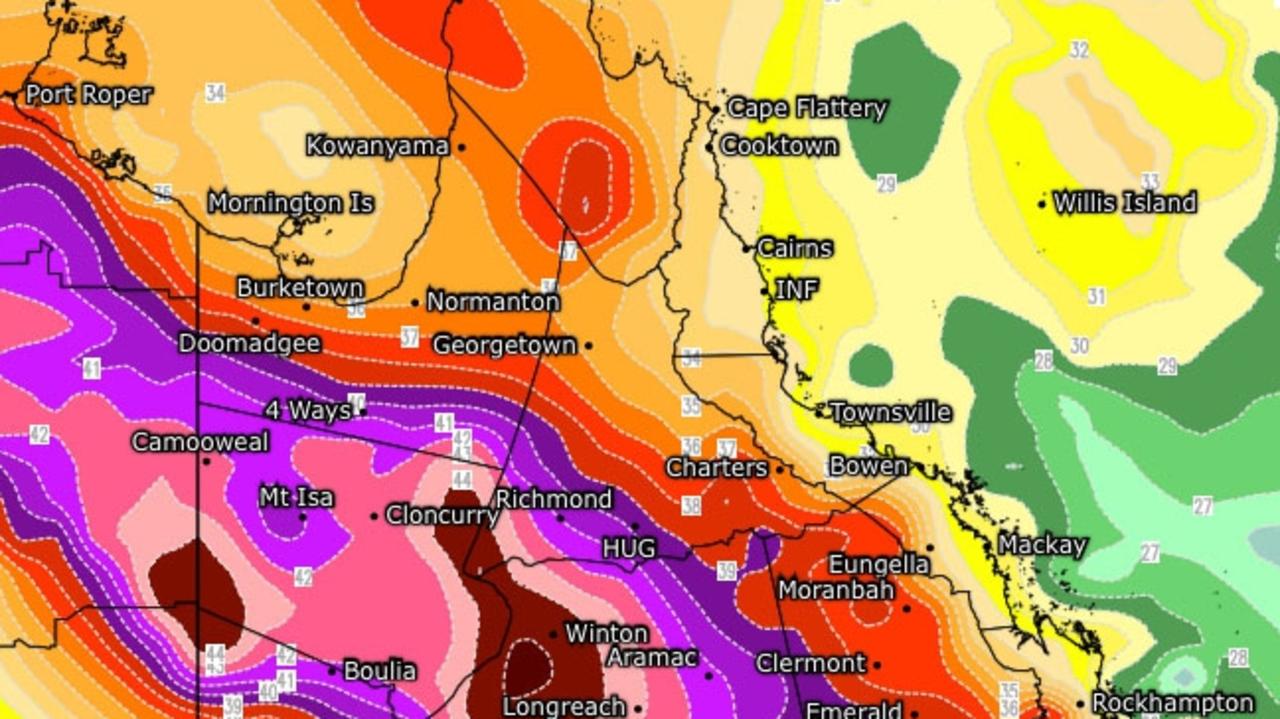
Mr Hines said 150 to 200mm of rain could be expected through central parts of the Northern Territory and northern parts of Queensland over a 24-hour period.
“Because of all this incoming rainfall there is a broad array of flood watches,” he said.
“Of particular note some of these areas in North West Queensland are still experiencing flooding from the exceptionally heavy rain over the past couple of weeks associated with ex-TC Kirrily.”
Mr Hines said areas including Burketown and Doomadgee should remain alert as roads remain shut and communities still isolated in the aftermath of Kirrily.
“Flood waters are still easing through some of these places but with the further incoming rainfall renewed rises are possible,” he said.
People in Queensland have been urged by the bureau to keep up to date with the latest warnings and to take precautions.
It is the third cyclone to hit Queensland in the past two months, following ex-TCs Jasper and Kirrily.
It comes after Brisbane was smashed by some of the heaviest rainfall since the 2022 event overnight with totals rising to as high as 181mm in Paddington.
More Coverage

30C at 10.40pm: Horror overnight temps as state swelters ahead of NYE storm threat
Heatwave conditions continue across Queensland with the minimum temperature remaining above 30C in one spot. It comes as the Bureau warns of a possible NYE storm threat.
Qld to bake in severe 47C heatwave
Queensland is in for a summer scorcher this week with temperatures to soar to 47C as severe heatwave conditions grip the state.