
Explainer: What’s behind South East rain bombs?
Repeat torrential downpours similar to the ones that brought down 300mm in three hours were set to smash “pockets” of South East Queensland on Tuesday night, as leading meteorologists explain what caused the unusual series of events.

QLD weather news
Don't miss out on the headlines from QLD weather news. Followed categories will be added to My News.
Repeat torrential downpours similar to the ones that brought down 300mm in three hours were set to smash “pockets” of South East Queensland on Tuesday night, as leading meteorologists explain what caused the unusual series of events.
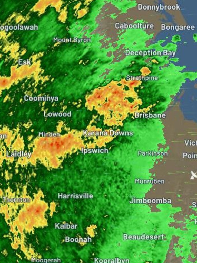
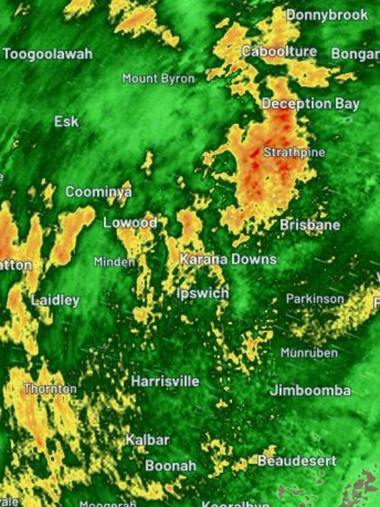
The Bureau of Meteorology warned parts of the South East to expect falls of 80-150mm, but with more “pockets” to record larger “intense” falls that lead to flash flooding.
Senior meteorologist Laura Boekel stressed that which locations might be in the firing line could change and “evolve” into the evening.
“So in terms of more intense rainfall, we are expecting that to continue today and tomorrow,” Ms Boekel said on Tuesday afternoon.
“Moving onto the rest of the week, we are likely to see an easing trend in the rainfall but definitely we are also likely to see more severe weather issued in the next 24 hours.
“In terms of the heavy rainfall that might lead to flash flooding, within the sort of next few hours and into tomorrow that’s 80-150mm.
“While we might see widespread rainfall areas, we will see pockets of more intense rainfall that leads to flash flooding.”

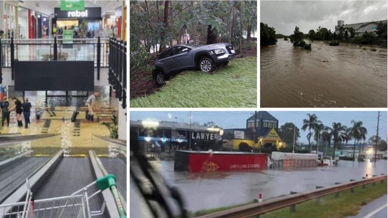
On Monday night, Samford recorded 351mm within a 24-hour period to 9am on Tuesday including 296mm in three hours in an “incredible” burst of rain, the Bureau observed.
Upper Caboolture also recorded falls of 209mm in just six hours and 187mm at Bells Creek.
A total of 16 gauges in the South East record more than 200mm of rainfall and “dozens” recorded more than 100mm.
So what caused the storm to be “stationary” for hours on end?
Ms Boekel explained that “normal” rain events contained steering winds that are high up in the atmosphere that essentially push clouds around.
“Usually they are quite quick, it means you can see the storm coming, you get rain for half an hour and then it moves on,” she said.
“That’s typically common in the South East.
“But if we don’t have steering winds you can get a mechanism where a storm moves very slowly, or stay stationary sometimes, so that’s where it produces a lot of rainfall in one spot.
“You can also get a mechanism that almost becomes a positive feedback loop which keeps triggering the rainfall, usually a trough, that’s causing all this rainfall.”
Ms Boekel said it was “not common” to see whether events of this nature.
Sky News Australia meteorologist Rob Sharpe said the weather patterns were more conducive for intense downpours in individual pockets as witnessed in Samford.
Mr Sharpe said the winds in the atmosphere were “reasonably calm” which helped the downpours virtually be stationary or slow moving.
So how did the conditions trigger this weather event?
Brisbane recorded a record amount of water in its atmosphere on Monday, according to the bureau’s measurements.
“An extra weather balloon was sent up this afternoon to sample the atmosphere ahead of expected severe weather. This showed 73.5mm of precipitable water, a new record for Brisbane Airport,” a bureau’s post on X read.
The records were brought on by ex-Tropical Cyclone Kirrilly, which sparked a heatwave of Bali-like humidity over the weekend.
“So it really is ex-TC Kirrilly. So that system has brought large amounts of moisture to large areas of the state, producing showers or storms that produce more rain, and in some areas, over a short period of time.
“Kirrilly was churning up all those warm oceans in the Coral Sea, bringing all that water and energy with it.
“So that’s bringing this really broad, widespread area of moisture, where we are seeing more rainfall within the showers and storms that you would typically see.”
Mr Sharpe claimed the bureau’s official precipitable water levels had actually been record breaking for Brisbane two days in a row.
Observing the Bureau’s website, Mr Sharpe said a new record of 74mm was set on Tuesday morning at Brisbane Airport.
“The bureau releases weather balloons every day, to see the precipitable water levels. So it broke the record yesterday, and then this morning it broke that record again,” Mr Sharpe said.
“We have never had this much rain above Brisbane ever, higher than the Brisbane floods a few years ago, and higher than in 2011.”


City’s coldest June start in 16 years, feels like MINUS 9.8C out west
Southeast Queensland is shivering through its coldest morning in more than 15 years but feels-like temperatures have dropped to insane levels in the southern inland.
Feels like MINUS 6.5C out west as Brisbane faces brutally cold, windy 24 hours
Residents in parts of southern Queensland have woken to their coldest morning of the year, with temperature dropping below zero in a number of places.