
Cyclone watch issued as Oma approaches southeast Queensland coast
A cyclone watch has been issued from Bundaberg to Ballina including Brisbane, the Gold and Sunshine coasts as Cyclone Oma continues its ominous approach to the southeast Queensland.
QLD weather news
Don't miss out on the headlines from QLD weather news. Followed categories will be added to My News.
A CYCLONE watch has been issued from Bundaberg to Ballina including Brisbane, the Gold and Sunshine coasts as Cyclone Oma continues its ominous approach to the southeast Queensland.
The slow-moving tropical cyclone is in the Coral Sea about 890km kilometres north-east of Brisbane.
RELATED: Cyclone may force southeast dam release | The Courier-Mail
57,000 sandbags as Oma heads towards southeast | The Courier-Mail
Water over roads through Brisbane as king tides and cyclone combine
How to pack an emergency kit for a cyclone
While forecasters predict the system is now only 20 per cent likely to hit the Queensland coast, warnings are in place for severe weather and hazardous surf conditions, and strong winds and up to 300mm of rain are expected in places.
People between Bundaberg and the Queensland-NSW border are being advised to consider what action they will need to take if the cyclone threat increases.
Premier Annastacia Palaszczuk was to receive a briefing on the cyclone this afternoon, with a Queensland Disaster Management Group meeting expected to be held tomorrow morning.
Speaking in Townsville, Ms Palaszczuk said the unpredictable path of cyclone had made it difficult for authorities to prepare.
“We have had unprecedented weather events in Queensland over the last two to three months – unprecedented on a scale of which I’ve never seen before,” she said.
“We will prepare as much as we possibly can. We will put the communication out to families.”

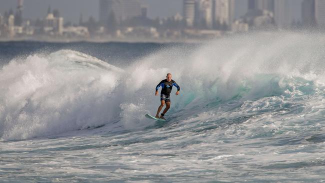
Surf Life Saving Queensland has confirmed all Gold Coast beaches and most beaches on the Sunshine Coast have been closed as a result of the combination of big swell generated by Oma and unusually high tides.
The Gold Coast’s $20 million beach protection defences will face their toughest test the swell builds.
In 2013, Cyclone Oswald’s fury carved a swathe of destruction across Glitter Strip beaches, robbing the Gold Coast of its most valuable tourism asset for weeks.
Now, as Oma tracks towards southeast Queensland, measures put in place since that disaster are in line for a severe battering with waves of up to five metres predicted to lash the coastline.

However, speaking to media on Thursday, Gold Coast Mayor Tom Tate said he was confident the beaches would cope much better with anything Oma could dish out.
“Planning is everything,” he said.
“I don’t see damage as bad as Oswald.
“Since then we haven’t stopped building up sandbanks, retaining walls, installing Geofabric sand bags, we have invested $20 million-plus.
“Now it is going to be tested by Mother Nature but I think the damage won’t be anywhere near as bad as Oswald.”
BEACH CLOSURES
All Gold Coast beaches
Main Beach, North Stradbroke Island
Cylinder Beach, North Stradbroke Island
Kings Beach
Dicky Beach
Buddina Beach
Mooloolaba
Maroochydore
Marcoola
Coolum
Peregian
Sunshine Beach
Noosa Main Beach
Rainbow Beach
All Gold Coast beaches are now closed, along with the majority of Sunshine Coast beaches. All beaches from Fraser Island down to the Qld border are likely to be closed by day’s end. Surf conditions will be powerful – please stay out of the water. #CycloneOma pic.twitter.com/Qf9RMKtHAP
— Surf Life Saving QLD (@lifesavingqld) February 21, 2019
As the category 2 system sits around 950km off the coast of Brisbane, tracking southwesterly at about 10km/h, uncertainty remains on what the cyclone will do, with the Bureau of Meteorology expecting impacts to be felt along the coast even if the cyclone does not cross land.
“The chance of Cyclone Oma hitting is less likely now, however it can’t be ruled out,” BoM forecaster Kimba Wong said. “There is a very low chance of it hitting the coast, about less than 20 per cent chance.”
#GoldCoast - All beaches have been closed by @cityofgoldcoast lifeguards due to #CycloneOma . Do not enter the water.
— Surf Life Saving QLD (@lifesavingqld) February 20, 2019
The BoM is warning of strong winds, high tides and swells along the coast, and potential heavy rainfall regardless of Oma’s direction.
“There are going to be pretty strong winds today of 40km/h, with gales starting tomorrow for Brisbane through to the weekend... quite windy along the coast and in elevated areas,” Ms Wong said.
“The heaviest rainfall will be concentrated further north at the Sunshine Coast and Fraser Island, however that is heavily dependent on what the cyclone will do.
“We could see up to 100mm of rain and in excess of 300mm in local areas – Brisbane will see 10 to 50mm this weekend while the Gold Coast will see 10 to 30mm on Saturday.”
Hazardous surf warnings remain in place for Queensland as well as severe weather warning for abnormally high tides for people in parts of Wide Bay, Burnett, Gold Coast, Maroochydore, Moreton Island, Noosa Heads, Caloundra and Rainbow Beach.
There is even more uncertainty as the weekend comes, with the possibility the cyclone could move further north to warmer waters or linger off the southern coast.
Overnight, forecasters were divided over what happens when Oma gets closer to the southeast Queensland coast, showing 20 different possible paths it could take.

An analysis provided to emergency groups shows a possibility the weather event will spear north and sit near Bundaberg for much of next week.
BoM forecaster Adam Blazak said one of the scenarios was Oma may “linger” off the southeast coast and this potentially could have an enormous impact, creating a sustained deluge.
Mr Blazak said if it hovered, it could produce rainfall totals of up to 100mm a day for a number of days, which could create flooding.
“The beaches will get beaten up and there will be rain and flooding, particularly south of Bundaberg. If it crosses the coast, we could see 500mm in some areas in one day, but it might head inland and help farmers.”
Mr Blazak said Oma was last night a Category-2 system, packing wind gusts of up to 130km/h.
Today, more effects will be felt, with winds increasing to 45km/h and a powerful long-period swell hitting the coast.
Tomorrow and Saturday will see winds reach 60km/h, with gusts up to 90km/h and the swell rising to 4m.
It was expected to close within 400km of the Sunshine Coast on Sunday before hooking in and then tracking north along the coast, but considerable uncertainty remained about where it may make landfall.
A combination of king tides, a super moon and early effects of Cyclone Oma have seen low-lying suburbs in Brisbane’s inner-north inundated with floodwaters. Residents in dozens of other areas also are at risk.
Levels at the mouth of the creek in Newstead were above the “minor flooding” mark yesterday morning, with water washing over Northey St in nearby Windsor.
Brisbane Lord Mayor Graham Quirk said council’s sandbag depots were fully stocked, with 57,000 sandbags available for collection.

Gold Coast Mayor Tom Tate urged all Gold Coasters to stay away from rock walls and the seaway, as large swells start to hit the coastline.
Water Police Senior Sergeant David Edden said people should avoid any type of boating and water activities near surf-exposed areas for at least the next five days.

Storm shield: How AI will protect our state of disaster
Queensland has secured world-first AI storm detection technology in a $3m partnership between Suncorp and the state government to revolutionise natural disaster response.

Hail, rain, wind, SNOW: Winter storm on Qld collision course
A rare winter storm threatens to dump 15cm of snow on Queensland's Granite Belt this weekend as forecasters warn of an incoming polar air mass.