
Cyclone Oma tracking towards southeast Queensland and could hit as far south as the NSW border
Emergency preparations are under way as Cyclone Oma continues her path towards southeast Queensland, bringing up to 500mm in a day, with thousands of sandbags ready and a veteran forecaster it’s never to early to get ready.
QLD weather news
Don't miss out on the headlines from QLD weather news. Followed categories will be added to My News.
SOUTHEAST Queensland could see more than 500mm of rain in a day if Cyclone Oma hits land over the coming days.
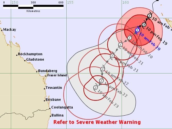
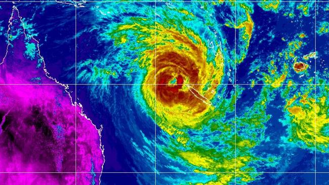
The Bureau of Meteorology is tracking the category 2 system about 1100 kilometres northeast of Brisbane, estimating that areas from the south of Gladstone to northern New South Wales to be affected if the cyclone does make landfall.
‘We’re moving anything not bolted down’
The BOM is also warning of hazardous beach conditions as the severe tropical cyclone is expected to move slowly southwest over the Coral Sea during the next few days.
“There is the possibility Cyclone Oma will cross land, however there is also the potential it will linger off the coast,” Forecaster Adam Blazak said.
“Impacts could be felt along the coast from south of Gladstone, down to northern New South Wales.
“People in that area are advised to keep an eye on updates to see if anything changes.
“We are currently monitoring it and there is a bit of uncertainty over what will happen... a cyclone watch will likely be issued this afternoon or tomorrow.”
He said if it lingered off the coast it would hang around for several days producing rainfall totals of 300mm in a day with falls of 500mm possible.
Those high totals would not be widespread. However the worst of it would see a series of rain-laden storms run over the one location for a number of hours.
He said coastal wind damage would occur as winds on Friday gusted to 90km/h.
Brisbane Lord Mayor Graham Quirk today said the council’s sandbag depots were fully stocked, with 57,000 sandbags ready to go.
“The Bureau of Meteorology has forecast rain over the weekend and Council remains alert, but not alarmed,” he said.
“Parts of Brisbane are also experiencing higher than normal tides and we encourage residents in bayside, riverside and low-lying areas to avoid parking their vehicles on the street.”
The sandbag depots can be found at:
- Darra - South Depot, 38 Shamrock Road
- Morningside - Balmoral Depot, 9 Redfern Street
- Newmarket - SES Depot, 66 Wilston Road
- Zillmere-North Depot, 33 Jennings Street
Mr Blazak said it could also potentially bring much-needed rain to drought-affected inland areas of the southeast corner.
“You don’t really want a crossing,” he said.
“But that would be maybe a better scenario than if it lingers off the coast.
“It would end up decaying and dropping rainfall in those dry areas.”
A severe weather warning remains in place from the Fraser Coast to the NSW border.
Tropical #CycloneOma 🌀 is currently southwest of New Calendonia and expected to approach the southern #Queensland coast over the weekend. A coastal crossing cannot be ruled out and the first Cyclone Watch may be issued later today: https://t.co/kL5As5Ml5e pic.twitter.com/rF2ChAqtXa
— Bureau of Meteorology, Queensland (@BOM_Qld) February 19, 2019
Bureau of Meteorology meteorologist Jonathan How warned that whether Oma makes landfall or not, “high-impact weather” is expected to lash Brisbane thanks to the system, the Gold Coast and the Sunshine Coast this Saturday and Sunday.
He said residents of the affected areas could expected “very heavy rainfall, gale force winds and storm surges,” and these conditions could possibly cause flooding.
Mr How explained that because Queensland hasn’t seen cyclonic conditions like this for some time it’s unknown how severe the effect of Cyclone Oma could be.
The Bureau is predicting the cyclone to move in a general southwesterly direction which will see it come closer to the southeast Queensland coast late in the week or over the weekend.
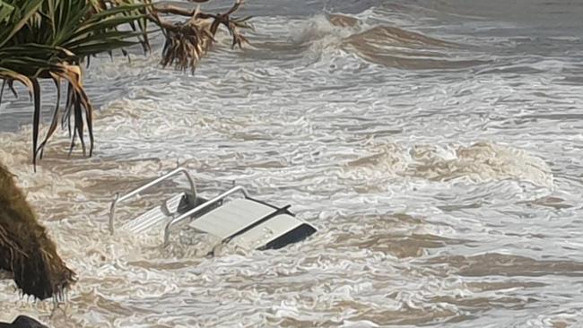
It means a perfect storm bringing king tides and massive swells could hit the region with its fiercest battering in years.
Waves of up to five metres are expected to hit the Gold Coast from tonight, with beaches already experiencing heavy erosion.
Former BoM forecaster Jeff Callaghan said it was never too early to start planning for severe weather.
He said the threat of intense rainfall was the biggest threat for Brisbane.
“As far as Brisbane goes, probably the biggest danger is the creeks,” he said.
“In the ’74 floods most of the damage came from the creeks flooding, whereas in 2011 it was the river flooding.”
He said there was a lot to be concerned about, with creeks all across the south east able to rise “instantaneously” with very little warning.
“It’s never too early to be prepared,” he said.
“People should be concerned and making plans if they are in a vulnerable area, they can go and get sandbags from the SES for free if they are worried.
“They should have a plan on where to move, in case they do get flooding.”
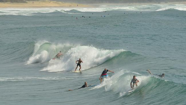
Dangerous surf conditions and severe weather conditions have closed two beaches along the Queensland coast, with more expected to close today.
Surf Life Saving Qld said Main Beach at North Stradbroke Island and Buddina Beach are closed due to the potential of Cyclone Oma causing large dangerous swells.
“We are expecting the swell to pick up around 3pm or later in the afternoon so we will see more beaches closed later in the day,” Surf Life Saving spokesperson Tibor Van-Maas said.
Modelling from Europe and the US shows the system could hit the Queensland coast by the end of the week, bringing 200km/h winds and up to 500mm of rain to the state’s southeast, but meteorologist Kimba Wong said there were still many different scenarios for how the cyclone will develop.
“It’s looking increasingly likely that it will track close to the southeast Queensland coast, (but) it’s difficult to say how close it will get at the moment,” she said.
Weather forecasters typically use dozens of different software programs to track a cyclone’s likely path, with some predicting Oma will about-face and turn northeast back out to the Pacific while other predictive models show it veering south to New Zealand.
However, respected models used in the US and Europe now show an increasing likelihood of the cyclone making landfall in Queensland.
Even if it does not cross the mainland, the BOM yesterday upgraded the likelihood of the cyclone impacting the coast to ‘high’, or greater than 50 per cent.
BOM has issued a hazardous surf warning for the region stretching from 1770 to the Queensland border with the likelihood of a dangerous surf warning to follow in the days ahead.
On the Gold Coast, council crews have begun removing sand dune fencing from vulnerable beaches expected to cop the worst of massive swells expected to roll in.
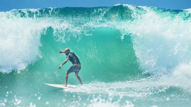
Gold Coast beaches remained open on Tuesday, but to the north, some beaches on the Sunshine Coast and North Stradbroke Island were closed. Further beach closures are expected, with monster 5m waves predicted, with local big wave surfers salivating at the prospect.
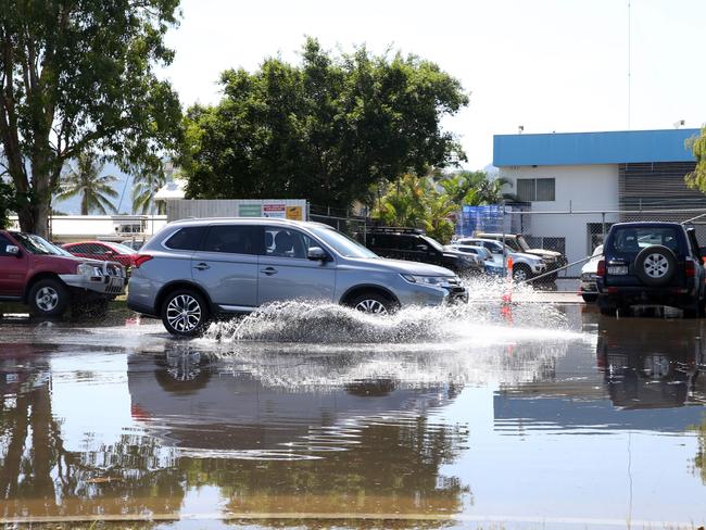
Meanwhile the Bureau of Meteorology (BOM) issued a severe weather warning for high tides for people in the Wide Bay, Burnett and south east coast at 11.00pm on Tuesday.
Increasing swell and abnormally high tides are expected south of Sandy Cap from Wednesday morning.
BOM has forecast the high tide could see water levels exceed the highest tide of the year by about half a metre on the morning high tide on Wednesday morning
They are expected to break high tide records again by about one metre on the morning high tides on Thursday and Friday morning.
The tropical cyclone Oma was still about 1200 kilometres northeast of Brisbane at about 10pm.
It is expected to move southwest over the next few days and will generate an increasing east to north easterly swell at Southern Queensland beaches.
Locations which may be affected include Gold Coast, Maroochydore, Moreton Island, Noosa Heads, Caloundra and Rainbow Beach.
Queensland Fire and Emergency Services advises that people should:
* If near the coastline, stay well away from the water’s edge.
* Never drive, walk or ride through flood waters. If it’s flooded, forget it.
* Keep clear of creeks and storm drains.
* For emergency assistance contact the SES on 132 500.

Storm shield: How AI will protect our state of disaster
Queensland has secured world-first AI storm detection technology in a $3m partnership between Suncorp and the state government to revolutionise natural disaster response.

Hail, rain, wind, SNOW: Winter storm on Qld collision course
A rare winter storm threatens to dump 15cm of snow on Queensland's Granite Belt this weekend as forecasters warn of an incoming polar air mass.