
Cyclone island: Bureau meteorologists in Jasper’s direct path
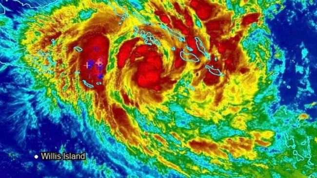
Tropical Cyclone Jasper is now a Category 4 storm with wind gusts of 260km/h and authorities say it could still intensify and reach Category 5 by time it impacts Queensland.
QLD weather news
Don't miss out on the headlines from QLD weather news. Followed categories will be added to My News.
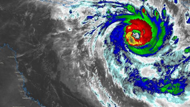
Cyclone Jasper has intensified to a Category 4 and is likely to cross between Townsville and Cooktown by early to mid next week, the Bureau of Meteorology senior meteorologist David Grant said.
The storm system is currently 1250km northeast of Cairns and producing wind gusts of 260km/h, while winds near the centre of the system are reaching 185km/h.
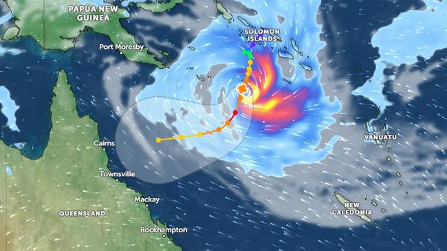
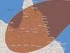
The seven-day tracker shows Jasper likely to cross the coast late Tuesday and into Wednesday before continuing across the far northern interior of Queensland.
There are 22 communities in the predicted impact zone.
“Cyclone Jasper is expected to go through a weakening phase over the weekend, however there is a significant risk the system could intensify as it approaches the North Queensland coast,” Mr Grant said.
Mr Grant said Cyclone Jasper could cross the coast around the middle of next week, but a cyclone warning could be issued as early as Sunday.
He couldn’t discount Cyclone Jasper intensifying to a Category 5.
“However, there is a considerable amount of uncertainty on how strong, and where the system will track over the coming days.”
Mr Grant said heavy showers would develop along the central and north coast of Queensland from Monday.
The Bureau would also closely monitor any possible flooding for coastal catchments in North Queensland.
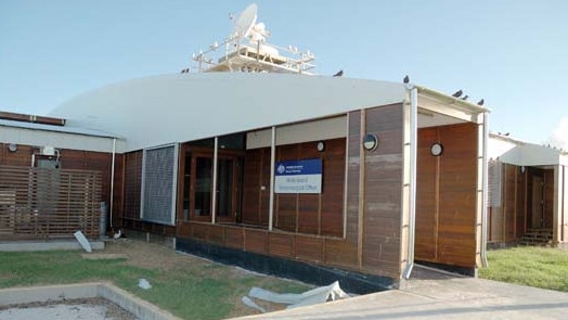
Mr Grant said the Bureau would make a decision on Friday on whether to evacuate four staff on Willis Island, about 450km east of Cairns
The weather station on little-known Willis Island is directly in the path of Tropical Cyclone Jasper.
Queensland Police Deputy Commissioner Shane Chelepy said residents north of Mackay needed to prepare their emergency kits.
“From Mackay, all the way through to Cairns, I have personally engaged with disaster co-ordinators and preparation is well underway in those areas,” Mr Chelepy said.
“We know that if we have a cyclone cross, the first 72 hours is critical for emergency services to be able to get our response mechanisms in place.”
He urged those in the cyclone’s predicted path to keep their car topped up with fuel, have enough food for three days, a charged power bank and a stock of bottled water.
Queensland Fire and Emergency Services Deputy Commissioner Kevin Walsh said crews were making plans and checking equipment to ensure they were ready for the cyclone.
Swift water rescue crews were also getting ready to deploy, if needed.
“When we get a little bit more certainty as to where this cyclone may cross, we will be deploying additional resources into those areas to help the local emergency services in the event that this turns nasty,” Mr Walsh said.
Bureau employees have been stationed at the remote Willis Island outpost since 1921, and play a critical role in gathering real time storm and cyclone data.

A Bureau spokesman confirmed four staff members were currently on the island and would be evacuated via helicopter “well before” Jasper’s arrival.
“The safety and wellbeing of our staff members is of absolute priority,” they said.
“We are monitoring the situation closely and have plans in place to evacuate staff via helicopter well before severe Tropical Cyclone Jasper presents any risk to the island.”
The rest of Queensland remains on alert ahead of the arrival of Jasper in coming days, with the Bureau forecasting it to cross land on the North Coast between Mackay and Cooktown some time “mid-to-late next week”.
Latest mapping shows Jasper producing wind gusts of 150km/h and centre wind speeds of 205km/h.

Jasper intensified from a category 3 cyclone to category 4 on Thursday night and is expected to weaken again on Saturday and Sunday.
Bureau of Meteorology senior meteorologist Laura Boekel yesterday said a cyclone ‘Watch Alert’ could be issued as early as Sunday.
“We … really encourage communities to be across that … it is when we’re expecting impacts between 24 and 48 hours,” she said.
“In terms of any communities affected, that will most likely be between Mackay and Cooktown.
“That’s kind of where the focus is at the moment, noting that there is quite a large amount of uncertainty with the system.”
Townsville and Mackay weather stations were scheduled for upgrades next week however the Bureau has since scrapped those plans and reassured residents they will be fully functional ahead of Jasper’s arrival.
Radar services taken offline for the upgrades will likely be put back in service from today.
In preparation for the potential impact of Cyclone Jasper, the Queensland Fire and Emergency Services (QFES) is proactively dispatching essential supplies to the Mackay and Townsville regions.
Despite the uncertain path of Cyclone Jasper, which is yet to be definitively charted by the Bureau of Meteorology, QFES is taking no chances and gearing up for a “worst-case scenario”.
Acting Superintendent of Technical Response Darren Welsh emphasised QFES’s readiness for the potential impact of Cyclone Jasper on the North Queensland coast, ensuring that all necessary supplies are at hand for the regions that might be impacted.
“In the next 24 hours is that trigger whether we send them off or not, but more than likely we will send three trucks up there, two semi trailers - heading up to Mackay and Townsville regions.”
He further elaborated on the preparation efforts, saying, “The last three or four days our personnel here at the state deployment center have been preparing and loading trucks for the possible deployment up north because we want to pre-position that equipment prior to if the cyclone hits landfall. So our guys here have been busy here, loading up trucks and preparing to possibly move out Sunday, but we’ll know more over the next day or two.”
Anticipating the potential aftermath of Cyclone Jasper making landfall, Mr Welsh highlighted the logistical challenges that might arise.
“So it’s just all about that pre-preparation work because we know in the past, trying to get resources in place after the cyclone hits landfall can be very difficult due to flooded roads, airfields being not being able to be used, so that pre-deployment of equipment is vital,” he explained.
In terms of the supplies being prepared, Mr Welsh detailed a comprehensive range of equipment aimed at dealing with various emergency scenarios.
“We have a whole range of equipment - but it’s all about structural collapse, the worst-case scenario if a cyclone hit a major regional centre,” he said.
“It’s structural collapse, swift water rescue gear, but also damage assessment gear for post-cyclone where we can do damage assessments of all properties and assess whether they’re habitable uninhabitable, what people need, who was in trouble and be able to direct resources to those parts of the townships that are worst affected.”
Mr Welsh also shed light on the comprehensive readiness measures being implemented on the ground.
Firefighters, swift water rescue teams, and State Emergency Service (SES) volunteers are actively preparing the regions for any potential impact of Cyclone Jasper.
“All our career firefighters, our swift water rescue technicians, we’ve got over 430 of them statewide. So they are positioned in each region,” he said.
“SES are also preparing for that as well, putting their volunteers in position and getting them resourced where they need to be, same as Queensland ambulance and police local governments. They’re all preparing and preparing for the worst-case scenario.”
In addition to these preparations, the QFES has issued guidance for Queensland residents to safeguard their properties against potential weather related threats.
“There’s a whole range of things people can do to prepare their properties, particularly for cyclones. Any loose items in the backyard should be secured or put away. Check your roof gutters, make sure there are no loose tiles. Keep all your windows down and secure if the cyclone is due to hit,” Mr Welsh said.
“Most importantly, listen to the radio, commercial radio, ABC Radio, local government webpages. Keep informed about your local area and what you need to do. And also, check the Queensland Fire and Emergency Services webpage.”
“It shouldn’t be anything unique or out of the ordinary for Queensland residents. We are the most disaster-prone state. We are always seeing flash flooding, flooded roadways, and so on throughout the state, not to mention bushfires.”
WHAT ARE THE CYCLONE CATEGORIES?
Category: 1 – Tropical Cyclone
Strongest gust: Less than 125 km/h. Gales
Typical effects: Minimal house damage. Damage to some crops, trees and caravans. Boats may drag moorings.
Category: 2 – Tropical Cyclone
Strongest gust: 126-164 km/h. Destructive winds
Typical effects: Minor house damage. Significant damage to signs, trees and caravans. Heavy damage to some crops. Risk of power failure. Small boats may break moorings.
Category: 3 – Severe Tropical Cyclone
Strongest gust: 165-224 km/h. Very destructive winds
Typical effects: Some roof and structural damage. Some caravans destroyed. Power failure likely.
Category: 4 – Severe Tropical Cyclone
Strongest gust: 225-279 km/h. Very destructive winds
Typical effects: Significant roofing and structural damage. Many caravans destroyed and blown away. Dangerous airborne debris. Widespread power failures.
Category: 5 – Severe Tropical Cyclone
Strongest gust: More than 280 km/h. Extremely destructive winds
Typical effects: Extremely dangerous with widespread destruction.
Source: Get Ready Queensland

Hail, rain, wind, SNOW: Winter storm on Qld collision course
A rare winter storm threatens to dump 15cm of snow on Queensland's Granite Belt this weekend as forecasters warn of an incoming polar air mass.
Read more

‘Can’t be ruled out’: Potential for freak Qld snowfall this week
Queensland could see snow this week with weather models predicting up to 14cm falling on the Granite Belt.
Read more