
Queensland weather: State braces for ‘Jasper’ as first tropical cyclone of the 2023 season forecast
Queensland is bracing for its first cyclone of the season, with the weather bureau keeping a close eye on a tropical low that is expected to develop into a category 3 tropical cyclone by Thursday.
QLD weather news
Don't miss out on the headlines from QLD weather news. Followed categories will be added to My News.
Queensland is bracing for its first cyclone of the season, with the Bureau of Meteorology keeping a close eye on a tropical low that is expected to develop into a category 3 tropical cyclone by Thursday.
Located in the Solomon Sea, the tropical low is expected to track south into Australian waters on Tuesday, before intensifying and entering the Coral Sea.
Weather bureau senior meteorologist Harry Clark said the bureau had high confidence the system would intensify as it continued travelling south and form a tropical cyclone by Wednesday, but that the system wouldn’t threaten the Queensland coast until next week.
“We have high confidence we will see a system develop into a tropical cyclone either late Tuesday or Wednesday and we have high confidence it will continue moving south into the Coral Sea,” Mr Clark said.
“Beyond that, there’s a lot of uncertainty.”
The tropical low system was travelling at a low speed of 13km/h on Monday night.
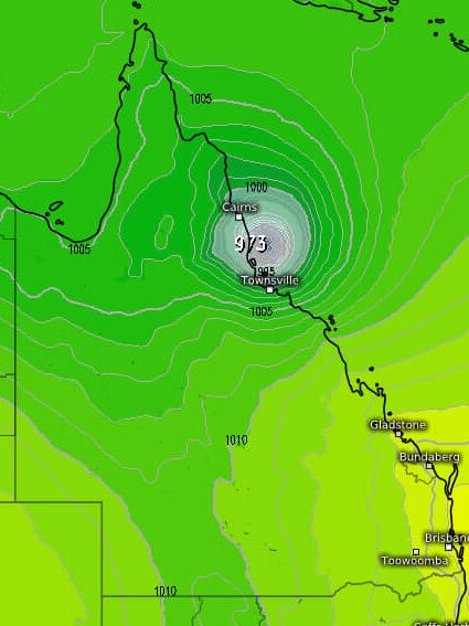
But if a tropical cyclone does form, it has potential to make landfall nearly anywhere along the Queensland coastline, with areas stretching from Townsville to the southeast corner under threat.
“It is a weak system at the moment, but as it does come further down, it could influx fairly severely and quickly,” Mr Clark said.
“We urge people to keep an eye on the forecast and make sure their have done their cyclone preparation.”
If the bureau does announce the cyclone, it will be named Jasper.
It would be the first tropical cyclone to develop during the official 2023 season, which traditionally runs from November 1 to April 30.
But it does come after an off-season tropical cyclone crossed Vanuatu in October.
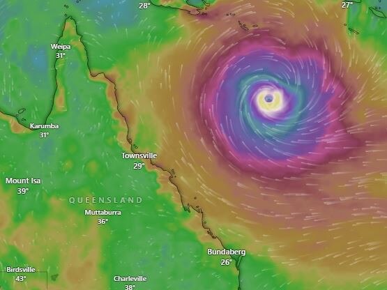
Tropical Cyclone Lola was a category 5 system, and an unusual occurrence in the Coral Sea for that time of year, producing nearly 300km/h wind gusts that ripped through northern Vanuatu.
“The difference between this and Lola is that one stayed in Fiji mainly, but this one will be in our (Australia’s) area,” Mr Clark said.
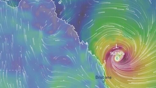
The bureau released its cyclone track map on Monday night that predicts Tropical Cyclone Jasper would form into a category 1 cyclone by 4pm on Tuesday, before intensifying to a category 2 by 4pm on Wednesday and a category 3 by 4pm on Thursday.
Mr Clark said Queensland’s weather next week would largely depend on where the system moved and whether the tropical cyclone remained out at sea.
“There’s a whole range of scenarios,” he said.
“If it nears the coast and remains a tropical low, there will be lots of high winds and rain.
“If it’s a cyclone, and it stays out to sea, there will be drier weather as it will take all of the moisture with it.”
A maximum temperature of 30C in Brisbane on Tuesday, 29C on the Sunshine Coast and 28C on the Gold Coast.
An alert was issued by the Bureau of Meteorology on Friday, forecasting a high chance of a tropical cyclone developing near the Solomon Islands or far northeast of the Coral Sea this week.
The Your Weather Channel JCW on Facebook has detailed three possible tracks, should the cyclone develop this week.
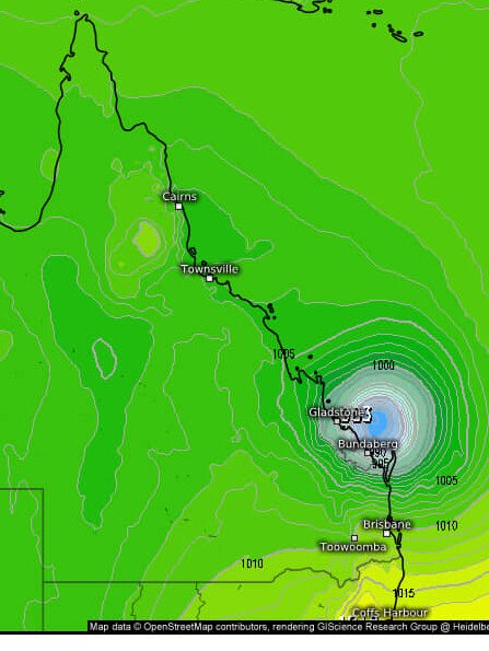
Two of the predicted cyclone pathways have the potential to cross land near Cairns and Townsville or further south at Gladstone and Bundaberg sometime early next week.
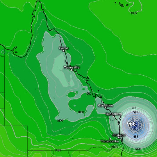
The other possibility include the cyclone tracking further south down the Queensland coastline, but remaining out at sea near the South East corner.
The amateur weather page says if the cyclone forms, it could threaten land anywhere from Townsville down to the NSW coast, with “most models” indicating the potential cyclone to hit or “slide down” the coast.
“Which was our nightmare scenario,” the page states.
Some forecast models have shown the system being off the Brisbane coast by Tuesday or Wednesday next week, however Mr Hayes said the Bureau would have a better idea in regards to its movements in the middle of the week.
“Some modelling suggests that it could be closer to the Queensland coast, but we would need a couple of days as it is still currently forming,” he said.
Daniel Hayes from the Bureau said at this point, the possible cyclone is still a long way out, so there is still uncertainty in the movement.
“It is looking like (the cyclone) will move into the Australian region in the next day or two,” he said.
“At this point in time it is looking like a high chance of being strengthened and organised enough to be categorised as a cyclone by Wednesday.”
From Wednesday to Sunday, Queensland’s east coast will experience a period of intense tropical low conditions, with the chance of heavy rains and damaging winds reaching their peak at 90 per cent on Thursday to Friday.
Throughout the week isolated showers and thunderstorms have been forecast across Queensland, while severe heatwave warnings remain in place for the far north and northeast.
Weather forecasters on social media are predicting the cyclone to form off the northern Australian coastline, before travelling in one of three directions.
While at this point it is not forecast to make direct contact with the Australian coast, Mr Hayes added there is always a chance the cyclone could move with uncertainty.
“Depending how close it comes to the coast there is the potential for strong winds and heavy rain, and if it approaches the coast we have the potential for severe storm impact,” he said.
The system is set to approach The Central Coast of Queensland before turning towards the south or southwest.
“Beyond that it is probably unlikely to turn to the north at that point,” Mr Hayes added.
Queensland is set for a calmer week after supercell storms lashed the state and caused widespread damage.
“There is still some storm activity around, but we are not looking at severe storm activity this week,” Mr Hayes said.
The bureau is forecasting a cooler change along parts of Queensland, with heatwave conditions contracting northwards over the next couple of days.
“We will still have severe to locally extreme heat conditions to the far northern parts of The Cape York region,” he said.
Mr Hayes warned that with dryer conditions, there would be a return of higher fire danger through the inland parts of the state.
“Fire dangers could rise from moderate to high for inland regions and extend to parts of the Capricornia coast and Mackay regions,” he added.
The Bureau have forecasted average temperatures along coastal areas for the rest of the week and warming up through inland parts of Queensland.

Feels like -5.3C: Icy blast sends temps plummeting again
South East Queensland has again shivered through a freezing start to the day, as a brutal cold front continues to blast the region with subzero temperatures, made worse by chilling winds.

Feels like MINUS 7.1C: Brutal cold front blasts southern Qld
A brutal cold front is blasting across southern Queensland with subzero temperatures and widespread frost.