Qld weather: Tropical Cyclone Jasper intensifies, gains speed
The state’s top cop has issued a warning as tropical Cyclone Jasper continues its path towards Queensland, with the Bureau of Meteorology admitting the impact could be far-reaching with severe storms and intense rainfall expected. LATEST ADVICE
QLD weather news
Don't miss out on the headlines from QLD weather news. Followed categories will be added to My News.
Queensland is ‘on alert’ as category 3 Cyclone Jasper continues to intensify, with the possibility it will become a category 5 by Thursday night and will impact regions north of Mackay early next week.

Bureau of Meteorology senior meteorologist Laura Boekel on Thursday said a cyclone ‘Watch Alert’ could be issued as early as Sunday.
“ We ... really encourage communities to be across that... it is when we’re expecting impacts between 24 and 48 hours,” she said.
“In terms of any communities affected, that will most likely be between Mackay and Cooktown.
“That’s kind of where the focus is at the moment, noting that there is quite a large amount of uncertainty with the system.”
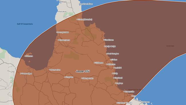
Latest mapping has zoned in on possible areas of impact, with towns between Coen down to Townsville and Ayr and inland to Mount Isa and Doomadgee now in the direct firing line.
Mornington Island is now also included in the red zone.
Ms Boekel addressed the issue of out-of-service weather radars in Mackay and Townsville, saying they’ll be back in service from Friday.
“It will be prioritised to make sure that’s turned on,” she said.
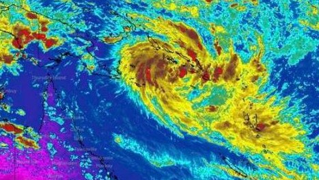
“Tropical Cyclone Jasper is quite a large system, which means that it does have a lot of cloud bands associated with it bringing showers and thunderstorms.
“So while we could see a crossing in a particular area we could definitely see rainfall ranging quite far out from where that core of that cyclone is, so over quite large areas could see severe storms as well as rainfall that can produce flash or riverine flooding.”
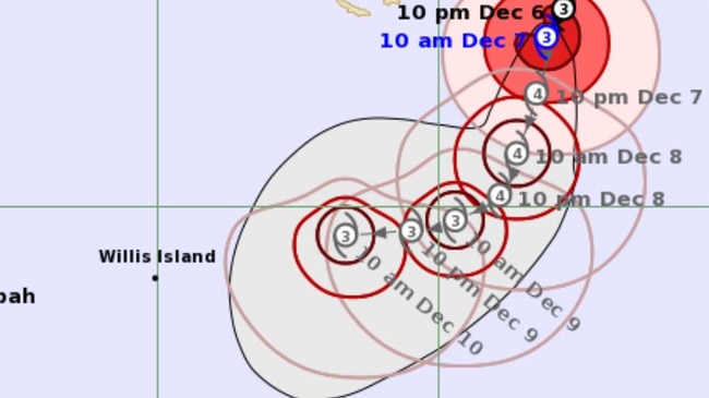
Jasper is currently tracking slowly towards the Queensland coastline, with the Bureau forecasting it to develop into a category 4 cyclone within the next 12 hours, before potentially becoming a category 5.
Latest mapping shows Jasper producing wind gusts of 195km/h and centre wind speeds of 140km/h.
Earlier on Thursday, the Burea said the system was moving very slowly.
“It has been a very slow night and morning so far, it hasn't tracked very far,” he said.
“It’s still tracking along as that category 3, it’s a fairly large system so it will take a while to see further development.
“We are still expecting a high category 4 tonight and a category 5 is on the cards, but certainly it will weaken as it tracks to the Queensland coast.”

Cyclone Jasper has been drawing large amounts of moisture into the upper atmosphere, leaving South West and Far North Queensland in the grips of a severe heatwave. Heatwave alerts have been issued for the Peninsula, Gulf Country, Channel Country, Maranoa and Warrego and Darling Downs and Granite Belt Districts until Saturday.
Ms Boekel said the dry conditions may drastically change from Monday depending on Cyclone Jasper’s path, which could bring cool cloud cover and possible storms to heat stricken areas.
“The heatwave is very high daytime temperatures but also quite high overnight temperatures so we’re really just not seeing a reprieve from that heat,” she said.
■ Bureau of Meteorology cyclone tracker

QUEENSLAND ON ALERT
Queensland Police Commissioner Katarina Carroll said the State Disaster Centre was “on alert” as Cyclone Jasper moved towards the Queensland coast.
“We will be getting a briefing every day now, and well into next week,” Ms Carroll said.
“The State Disaster Centre is basically on alert, monitoring every day and briefing.”
Ms Carroll urged the public to not be complacent.
“We haven’t had a big cyclone since 2017, that was Cyclone Debbie. A lot of the population has changed up and down the coast, there’s a lot of people on holidays at the moment.
“Please just listen to the radio, newspaper... just be well-informed and well-prepared.”
WHAT ARE THE CYCLONE CATEGORIES?
Category: 1 – Tropical Cyclone
Strongest gust: Less than 125 km/h. Gales
Typical effects: Minimal house damage. Damage to some crops, trees and caravans. Boats may drag moorings.
Category: 2 – Tropical Cyclone
Strongest gust: 126-164 km/h. Destructive winds
Typical effects: Minor house damage. Significant damage to signs, trees and caravans. Heavy damage to some crops. Risk of power failure. Small boats may break moorings.
Category: 3 – Severe Tropical Cyclone
Strongest gust: 165-224 km/h. Very destructive winds
Typical effects: Some roof and structural damage. Some caravans destroyed. Power failure likely.
Category: 4 – Severe Tropical Cyclone
Strongest gust: 225-279 km/h. Very destructive winds
Typical effects: Significant roofing and structural damage. Many caravans destroyed and blown away. Dangerous airborne debris. Widespread power failures.
Category: 5 – Severe Tropical Cyclone
Strongest gust: More than 280 km/h. Extremely destructive winds
Typical effects: Extremely dangerous with widespread destruction.
Source: Get Ready Queensland
■ Bureau of Meteorology cyclone tracker
Read related topics:Weather


