
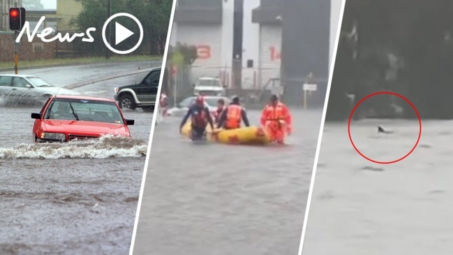
Queensland weather: Flood warnings in place as storms, wet weather continue
As more storms began to roll in across the southeast, flood warnings were issued across 11 Queensland catchments. But QFES have now cancelled many of the flood alerts, meanwhile elsewhere in the state, a heatwave has set in.

QLD weather news
Don't miss out on the headlines from QLD weather news. Followed categories will be added to My News.
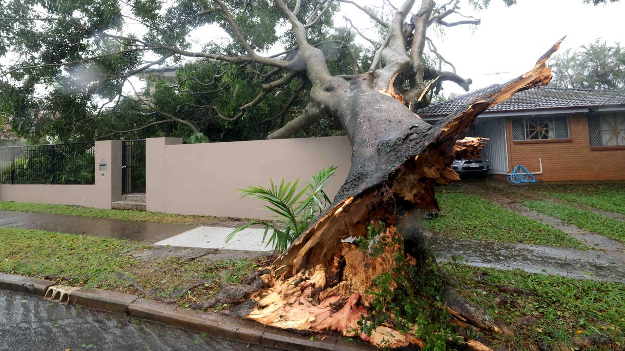
SEVERE thunderstorms have rolled through parts of the southeast, dumping heavy rainfall, including 50mm in an hour, on the region.
Queensland Fire and Emergency Services have just cancelled multiple emergency flood alerts, after local residents were told to secure their belongings and prepare for home flooding.
Western Downs and Toowoomba region residents have been told by QFES the Emergency Alert for Bell, Oakey, Jondaryan, Dalby, Kaimkillenbun and Jandowae have been cancelled just before 1.30pm this evening.
Multiple warnings were issued earlier today, although none are current, with the highest rainfall being recorded at Baroon Boat Camp in the Sunshine Coast hinterland.
Close shave with cyclone to bring rough conditions
Locals were being urged to prepare for flooding, with flood warnings issued for 11 catchments across the state.
Further rainfall in excess of 100mm is expected in the southeast, to add to the downpours already experienced in the past week.
Lyndsay Road, Buderim (west of Jones Road) has been closed due to flooding. Please avoid the area and remember, if it's flooded, forget it! #QldTraffic pic.twitter.com/aeUNo1uf1o
— RACQ (@RACQOfficial) February 12, 2020
Queensland Fire and Emergency Services issued an emergency flood alert for residents in Jandowae, Western Downs at 9.30am, with Jandowae Creek expected to peak today from heavy rainfall.
“This may lead to major flooding in the area. Properties are likely to experience flooding,” the alert said.
“Residents are advised to secure their belongings, prepare to leave and warn neighbours.”
There is one Major Flood Warning for Marion Downs’ Georgina River as flood levels are expected to remain over the next few days.
Flooding in the lower Georgina River has been caused from rainfall in the upper parts of the catchment which fell more than a week ago.
The Georgina River was at 5.65 metres and rising at 9am on Monday with river levels expected to remain above the major flood level for at least the next few days.
There are also Moderate Flood Warnings issued for Burke Development Road on the lower Flinders River, Eyre Creek, Condamine River, Balonne River, Moonie River and Weir River.
Minor flood warnings remain for Myall Creek, Bulloo River, Dawson River, Paroo River Thomson River, Cooper Creek and Upper Brisbane River.
Severe storms with heavy rainfall likely for #SEQld today & possible in the far north. Warning current for storms over the #SunshineCoast. Storms around the #GoldCoast have temporarily weakened, but further warnings are likely to be issued today. Warnings: https://t.co/FBmpsInT9o pic.twitter.com/IVbbW4orgg
— Bureau of Meteorology, Queensland (@BOM_Qld) February 12, 2020
Additional flood warnings are issued for the Fitzroy Catchment, Barcoo River and Diamantina River while a Flood Watch for south east catchments between Bundaberg and the NSW border is also in place.
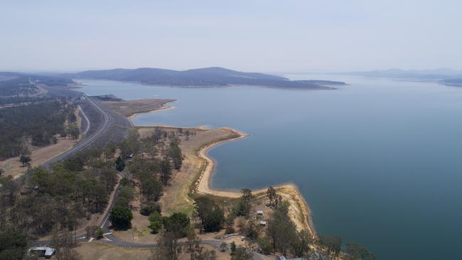
The heavy rainfall still hasn’t been enough to lift water restrictions triggered in November last year with the southeast’s main water supply “still less than half full”.
The 60 per cent Drought Response water restriction is likely to stay in place for a while longer, as SEQWater say it’s necessary to note “Wivenhoe dam – our largest storage – is still below 50 per cent”.
“It’s too early to say if the rain is the start of drought recovery or temporary relief from dry conditions,” a SEQWater Spokesman said.
Wivenhoe Dam is currently measuring at 47 per cent and despite other smaller south east dams spilling, the Gold Coast’s Tugun Desalination Plant is still operating to take pressure off Wivenhoe’s demand.
SEQWater are stressing the importance of wise water use.
“We are still encouraging all south-east Queenslanders to continue using water wisely to help preserve dam storages until they are sufficiently replenished,” a statement said.
“One benefit of the rain is that it allows rainwater tanks to be topped up and helps people conserve water by not having to water their lawns and gardens or top up swimming pools.
“Further rain is expected through to Friday however there remains uncertainty in the forecasts.”
The overall level of the Water Grid storages increased by 1.8 percent since 9am yesterday.
“… mostly due to the catchment flow continuing throughout the region rather than overnight rainfall... The Water Grid capacity is now 61.4 percent”.
Water Grid storages have gained about 11 to 13 weeks of additional water supply since current rainfall began nine days ago on February 3.
“Based on South East water use in the past six months, the Water Grid storages have received approximately 11 to 13 weeks of additional supply,”
“The Water Grid storage volume has increased by approximately 122,000 megalitres (million litres) since inflows commenced on Monday 3 February 2020”.
AROUND QUEENSLAND
Across the state, experts say rainfall conditions are likely to stay similar to those seen over the past few days, with parts of the southeast to see rainfall in excess of 100mm.
“It’s very likely Brisbane will have showers across today and tomorrow … as we go into the week, conditions will ease, with a partly cloudy week forecast and slight to medium chance of showers,” Bureau of Meteorology Forecaster Kimba Wong said.
Several roads across the state are currently fully closed from flash flooding caused by heavy rain, and Ms Wong said most of the affected areas can expect more.
Dalby is among one of those, as Dalby Kogan Road remains closed to all traffic and local residents are said to brace themselves for possible thunderstorms across today and tomorrow.
“These thunderstorms are likely to bring heavy falls … there is definitely potential Dalby rivers will rise in the next few days.”

Meanwhile, while most of the state is reaping repercussions of heavy rainfall, forecasters say north Queensland can expect an extreme heatwave as temperatures reach the low 40s.
Hinchinbrook is in for a big week with “February records for minimum and maximum temperatures” likely to be broken with “very hot and sunny” forecasts.
Bureau of Meteorology Forecaster Kimba Wong said Ingham is forecast to reach 42C on Thursday, with overnight temperatures falling to the low 20s.
“It’s likely Igham and the surrounding areas will experience a severe to extreme heatwave, covering the next several days as the heat builds,” Ms Wong said.
“Tomorrow in the Herbert and Lower Burdekin area it will be hot and mostly sunny with a chance of a thunderstorm in the south,
“Temperatures will rise and Friday is expected to be very hot and mostly sunny with north to northeasterly winds 15 to 20 km per hour turning west to north-westerly during the morning”.
Cyclone insurance claims soar
More than 31,000 claims were lodged across the southeast after ex-tropical cyclone Alfred dealt widespread damage to thousands of houses, properties and cars. See where the most claims were made.
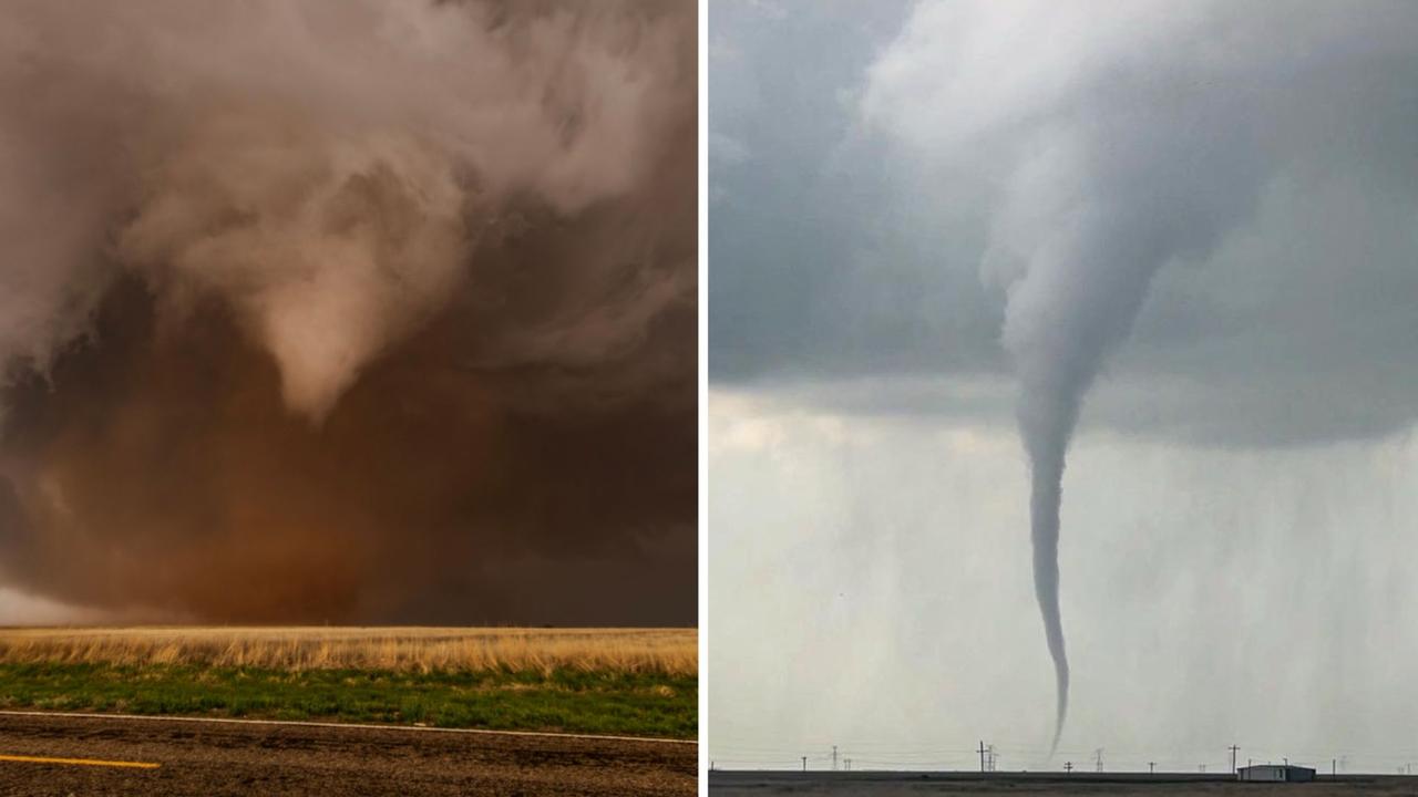
Roof tearing tornadoes captured by Queensland storm chaser
A Queensland storm chaser has captured remarkable photos of destructive tornadoes that have wreaked havoc across Texas. SEE THE PHOTOS