
Brisbane weather: Reprieve as storm activity moves offshore
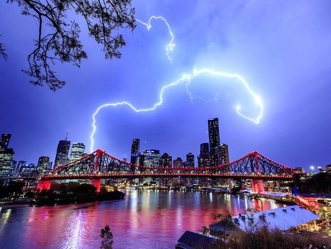
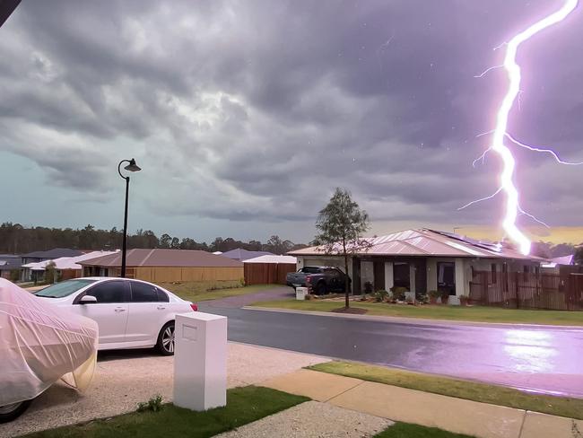
Thousands were without power and a home caught fire as destructive storms delivered 100,000 lightning strikes across southeast Queensland yesterday. Storms are still possible today, with the threat of supercell storms to build into the weekend.
QLD weather news
Don't miss out on the headlines from QLD weather news. Followed categories will be added to My News.
Storms are again possible in Brisbane today as the threat of the destructive supercells that have wreaked havoc across southeast Queensland over the past two days builds towards the weekend.
For a second day, severe thunderstorms with giant hailstones, heavy rain and damaging winds lashed areas of the Sunshine Coast and Brisbane yesterday, with about 100,000 lightning strikes recorded, most between midday and 6.30pm.
More wild weather on the way after severe storms batter southeast
Queensland weather: Brisbane in firing line as supercells bring deluge across the southeast
A house on the Gold Coast caught fire after being struck last night, and almost 4000 southeast properties were left without power by 9pm.
Traffic lights at Queen St in the CBD and Vulture St at Woolloongabba were out in all directions, while Gympie Arterial Rd at Bald Hills north of Brisbane was partially closed due to flash flooding.
Mt Glorious northwest of Brisbane received 60mm of rain from 9am-11pm, Baxters Creek 54mm, Browns Creek Rd 55mm, Upper Caboolture 51mm and Kallungur 52mm.
Gympie was hit particularly hard, with Pomona measuring 60mm of rain and areas just north recording above 65mm.
Giant hail was reported at Toowoomba, Proston and Banana yesterday as 74mm of rain was recorded at the Cedar Vale, southwest of Gladstone.
Home Park west of Fraser Island, received 62mm, while Pomona recorded 43mm.
The Brisbane gauge on Tuesday recorded 72mm, making it the city’s wettest October day since 2010 and its second wettest day since the gauge was set up about 20 years ago.
But the Bureau of Meteorology predicts storms will move offshore in coming days as temperatures peak along the coast tomorrow.
Weather bureau meteorologist Rosa Hoff said rain would briefly return to the southeast on Saturday, with potentially large and severe storms.
“There is a possibility of getting some severe storms on the Scenic Rim or on the Granite Belt, but not really away from there,” she said.
A flood warning remains in place for the Diamantina River, with levels rising slowly.
The southeast Queensland water grid rose 0.2 points in the past week to 57.8 per cent capacity – one of the lowest recordings since February.
Despite the huge rainfall on the southeast coast, central regions of Queensland will be plunged into severe fire conditions today.
Fire danger ratings in the central west and Maranoa and Warrego regions, including Longreach and Charleville, will reach “severe” levels because of a combination of warm and dry air with strong northwesterly winds.
TOP RAINFALL ON WEDNESDAY
Cedar Vale – 74mm
Table Tops – 63mm
Home Park – 62mm
Magnolia – 51mm
Pomona – 43mm
Maroochydore 25-35mm
Northern Gold Coast – 20-30mm

Ice ice baby: Spectacular images of unseasonal frost as Qld freezes
Queensland’s overnight temperatures will increase to double digits in the coming days, following the coldest start to winter in 16 years, bringing frost and ice to many regions. SEE THE PHOTOS

City’s coldest June start in 16 years, feels like MINUS 9.8C out west
Southeast Queensland is shivering through its coldest morning in more than 15 years but feels-like temperatures have dropped to insane levels in the southern inland.