
Australia Day weekend: Southeast set for storms, extreme heat in wake of Kirrily crossing
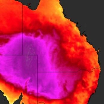
Temperatures in one Queensland town soared past 49C by 3pm, creeping tantalisingly close towards a potential record-breaking maximum of 50C.
QLD weather news
Don't miss out on the headlines from QLD weather news. Followed categories will be added to My News.
Authorities in Queensland were gearing up for the possibility of a long weekend of weather extremes across the state as Tropical Cyclone Kirrily barrelled toward the coast on Thursday.
The Queensland-South Australia border was facing possible maximum temperatures exceeding 50C, with the potential to break the state’s record high of 49.5C, reached at Birdsville in 1972, but fell just short.
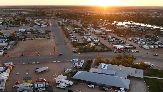
It was Birdsville that came closest to setting a new record, reaching 49.4C by 2.33pm – just 0.2C away from a new maximum.
Nearby, Ballera reached a maximum of 46.3C, while Thargomindah topped out at 43.9C
Other Queensland locations to exceed 40C included Longreach (42.5C), Blackall (41.1C), Winton (40.6C), St George (40.9C), Windorah (43.5C and Julia Creek (40.3C),
With Cyclone Kirrily’s southerly trajectory looking less likely after landfall, southern Queensland would face scorching temperatures and storms.
Kirrily’s arrival coinciding with hot temperatures and a humid burst of humid Coral Sea air was expected to “sear” parts of inland Queensland from Thursday.
The Bureau’s Angus Hines said Birdsville had been forecast to reach 49C, just half a degree off its all-time record.
“The heat across the centre of the country at the moment, including southwest Queensland, is right up there, as hot as that part of the country gets. Forty-nine degrees is exceptionally hot,” he said.
“But those temperatures do not get to coastal areas … with the cyclone comes a little bit of cloudiness as well.”
The forecaster said the coast would still face above average temperatures reaching into the mid-30s in the southeast.
“We could see some spots up at 33 to 35 degrees over the few days following the passage of the cyclone,” he said.
“We’re going for 36C on Saturday in Brisbane, which is fairly warm for that part of the country and of course it will be a very humid 36C as well, so feeling very muggy outdoors.”
Lord Mayor Adrian Schrinner warned Brisbane residents to prepare for “violent storms and potentially flash flooding” over the weekend, if the rain is heavy enough.
“The ground is saturated, that means the run-off can be fast and furious and create flash flooding in certain areas,” he said on Thursday.
“We’ve geared up, we’ve got 100,000 sandbags available for collection, we have teams out there across the city and SES volunteers on standby as well.
“We will be okay if everyone is ready, and we hope it is an anticlimax and a fine weekend, but we need to be ready for the worst.
“We know things can change really quickly when it comes to the weather in Queensland, we saw that happen over Christmas.”
The Bureau of Meteorology’s latest modelling suggested Kirrily’s trajectory in a west-southwest direction with impacts likely to be felt about interior Queensland and then out toward western Queensland and the Northern Territory.
The Bureau was cautiously monitoring three major potential hazards including heavy rain and floods, gale force winds, and a storm swell within the warning area from Innisfail to Sarina and west past Charters Towers.
Mr Hines said the southeast was in for potential storms across the weekend.
“What is going to happen as Kirrily makes its way across central and western Queensland, it brings in more really humid and warm air across pretty much the entire state,” he said.
“So there’s certainly a risk that we will see some showers and storms across the southeast, particularly once we get to the weekend.”
He said a pulse of warm and humid air would come with or behind Kirrily, resulting in another stormy day or two.
“Saturday and Sunday, we see a high chance of showers and the possibility of storms to the likes of Brisbane and the Gold Coast,” he said.
The forecaster expected isolated rainfall of up to 30mm each day.
Read related topics:Weather
Join the conversation

Ice ice baby: Spectacular images of unseasonal frost as Qld freezes
Queensland’s overnight temperatures will increase to double digits in the coming days, following the coldest start to winter in 16 years, bringing frost and ice to many regions. SEE THE PHOTOS
Read more

City’s coldest June start in 16 years, feels like MINUS 9.8C out west
Southeast Queensland is shivering through its coldest morning in more than 15 years but feels-like temperatures have dropped to insane levels in the southern inland.
Read more