
Abnormal cold ocean pocket threatens to flood South East Queensland
Experts have discovered a freak weather phenomenon off South East Queensland that could explode to life post-La Nina, triggering another severe flood event.
QLD weather news
Don't miss out on the headlines from QLD weather news. Followed categories will be added to My News.
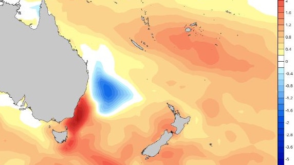
South East Queensland could be whacked with a severe flood event post-La Nina, thanks to an ocean temperature anomaly currently developing off the Gold Coast.
The vortex of cold air could be revived like a zombie once La Nina has unleashed on the state.
Both the Bureau of Meteorology and Brisbane Weather modelling predicts La Nina will weaken from January onwards, reducing the likelihood of above average rainfall.
A spokesman from the BOM climatology team said La Nina is still expected to peak during spring and “return to normal conditions in early 2023”.
“All seven surveyed international climate models show La Niña thresholds (−0.8 °C) will continue to be exceeded during October, with five exceeding the threshold until at least the end of 2022,” he said.
“All but one model is forecast a return to neutral conditions, i.e. an end to the La Nina event, by February 2023.”
However, there are new concerns a for South East Queensland with a “cold pool” currently developing off the east coast near the Queensland New South Wales border.
Forecasters say the cool pool has created an isolated ocean area consisting of below average water temperatures, which could mix with surrounding warmer coastal waters, leading to convection and possibly another serious flood event.

The climatology spokesman said the Bureaus’ ocean temperature outlook showed the cold pool dissipating by January, but could not confirm if it would cause a significant rain event before or during January.
“It is not possible to forecast rainfall leading to specific flood events by local region more than 3 to 5 days in advance,” he said.

But Brisbane Weather forecasters say they are worried about the size of the cold pool and will be watching it closely over the next two months.
“Between January and February, there will be a warming trend along the coast, and if we get some heating temperatures between that cold pool and the coast, it’ll really fed off the moisture, which I believe should create a significant flood for SEQ and NSW,” the Brisbane Weather founder said.
“That’s my biggest worry … I’ve spoken to a few other storm chaser as well and they are concerned too.”
“It’s a real anomaly.”

Ice ice baby: Spectacular images of unseasonal frost as Qld freezes
Queensland’s overnight temperatures will increase to double digits in the coming days, following the coldest start to winter in 16 years, bringing frost and ice to many regions. SEE THE PHOTOS

City’s coldest June start in 16 years, feels like MINUS 9.8C out west
Southeast Queensland is shivering through its coldest morning in more than 15 years but feels-like temperatures have dropped to insane levels in the southern inland.