
Warwick weather: Up to 100mm forecast only days after flood waters sweep Warwick
‘If it’s not flash flooding, it’ll be riverine flooding’: Another deluge is set to hit Warwick and the Granite Belt only days after flash flooding and dramatic water rescues swept the region. Get the full forecast here:
Warwick
Don't miss out on the headlines from Warwick. Followed categories will be added to My News.
Experts are warning the Warwick community that even more rainfall is on the way only days after parts of the region were inundated and residents were rescued from floodwaters.
Latest forecasts from the Bureau of Meteorology suggest Rose City residents could score up to 100mm of rain between Monday and Wednesday, with the possibility of 60mm on Tuesday alone.
Stanthorpe and the wider Granite Belt could see similar figures with 35mm – 50mm on Tuesday and another 10mm – 25mm on Wednesday.
BOM meteorologist Helen Reid said the large downpours would be widespread and affect almost the entire region, with a chance of more concentrated thunderstorms from Thursday.
“There’s lots of moisture in the atmosphere, and that’ll be especially heading into tomorrow and Wednesday,” she said.
“Those flash flooding risks have really increased given there’s just so much rainfall happening, and everything is so wet already that we’ve seen a few rivers go straight up.
“If it’s not flash flooding, it’ll be riverine flooding. It’ll be a bit dependent on where the thunderstorms drop the rain, but it’s something we need to be wary of.”
The wild weather may hit sooner than first expected, as BOM issued a severe weather warning for the region at 3.48pm on Monday for widespread and heavy rainfall.
It anticipated six-hourly totals of 50mm – 80mm from late Monday night into Tuesday morning, which could lead to flash flooding.
BOM data indicates Warwick has now received 184.2mm of rain in November and Stanthorpe 215.4mm, more than doubling each town’s monthly average.
The huge rainfall predictions come only days after a deluge battered the region and left roads across the region closed or damaged by flash flooding.
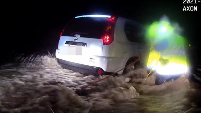
Three women and a six-week-old baby were rescued from floodwaters on Saturday night, with police and emergency services needing to use rope and a human chain to pull those in danger to safety.
The alarming incidents prompted Darling Downs District Superintendent Danny Shaw to issue a stern warning to flood-affected residents.
“As we can see from these incidents overnight, flash flooding can occur very quickly and without any notice, even on roads that you usually travel on without any issues,” Superintendent Shaw said.
“I’m urging residents to use common sense – back away from flooded roadways, delay your journey if necessary. If it’s flooded, forget it.”
The Condamine River at Warwick is continuing to drop after clocking 3.26m at 4.55pm on Sunday, and peaked at Pratten at 5.6m the same day.
The latest update from Southern Downs Regional Council says Warwick Yangan Road at Swan Creek remains closed to all traffic and floodwaters are still receding at Murrays Bridge.
Leslie Dam has now reached 77.12 per cent, while Storm King and Connolly Dams are still both at 100 per cent capacity.


Warwick sale and auction results, week ending July 12
Warwick proved to be a hot market last week with six properties selling for a total value of $3.6 million. See the latest auction and sales results.

Monsters, lawless teens: Inside record number of Qld court appeals
Since taking the legal helm of a state rocked by senseless crimes, Qld’s Attorney-General has challenged a record number of sentences. We speak to the families of victims and get rare insight into the process.