
Sub-zero temperatures continue in SEQ amid rain threat for state
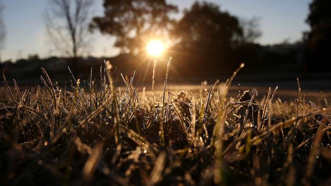
Queensland’s south remains in the grip of a frosty blast that’s producing early morning subzero temperatures while rain threatens to dampen school holiday fun further afield.

QLD News
Don't miss out on the headlines from QLD News. Followed categories will be added to My News.
The first week of school holidays in Queensland may be cold and wet as subzero temperatures and rain forecast about the state.
As the icy grip of winter held tight with sub zero temperatures recorded on Monday morning, The Bureau of Meteorology was expecting rain later in the week.
Meteorologist at the weather bureau Jack Prigg said South East Queensland would likely see between two and five millimetre showers on Thursday.
“There’s a slight chance of showers coming in before that, tomorrow potentially, but Thursday really is the main rain day with a shower or two,” he said.
“That’s just from a trough moving across the state inland and got a bit of moisture ahead of that.”
Mr Prigg said The Bureau had forecast isolated showers possibly developing as soon as Tuesday about the Far North, northern interior and north Queensland into the evening.
“Then Wednesday it will be cloudy with scattered showers or patchy rain in northern and central Queensland and the adjacent interior,” he said.
“On Thursday the falls may be more widespread, clouds with scattered showers or patchy rain across eastern and those adjacent inland districts.”
The trough was forecast to develop in the northern and central interior during Tuesday, drawing moisture well inland and generating cloud and showers over northern and eastern districts.
The rain could be widespread, between Cooktown and the New South Wales border, with moderate falls in Central Queensland and scattered showers about the eastern Peninsula and Torres Strait.
The Bureau expected the trough to likely linger for several days, weakening towards the end of the week, with isolated falls possible in eastern Queensland from Friday to Sunday, tending scattered about the North Tropical Coast.
On Sunday a cloud band with scattered to widespread rain moves across southwestern Queensland.
Some areas in Central Queensland, including Rockhampton and Gladstone, are forecast to record up to 15mm later in the week.
Mr Prigg said after the trough passes through on Thursday, the South East could expect ‘cloudy and average conditions’ for the weekend.
Temperatures remained icy throughout southern parts of the state on Monday as clear skies welcomed a cool morning with frost inland and sub zero minimums about the Granite Belt.
Brisbane residents on Sunday shivered through their coldest morning of the year when the Bureau recorded a minimum temperature of 7.7C.
Mr Prigg said people in Brisbane, Dalby and Oakey all woke up to the coldest morning of 2024 so far on Sunday.
”Oakey was cold this morning but yesterday -3.9C was the coldest of the year so far but not record breaking,” he said.
“Dalby was -2.4C and in Brisbane yesterday was its coldest morning of the year so far. It was 7.7C in the city.”
Applethorpe, Oakey and Warwick were the coldest in the state on Monday morning, with the Applethorpe town dropped to -2.2C and the others -2C.

‘We get bugger all’: Backlash over Brisbane tunnel ’stunt’
A tunnel to bust congestion, or just digging a bigger hole for Queensland? HAVE YOUR SAY

Listen: Massive explosion rocks suburbs
CCTV has captured an explosion that destroyed a caravan and shook homes across several suburbs north of Brisbane. WATCH THE VIDEO