
Central Queensland wet weather to continue all week, SES warn people to prepare their homes
Central Queensland is under a flood watch warning as the state prepares for a big wet over the next few days. Here’s what you need to know.
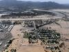
Rockhampton
Don't miss out on the headlines from Rockhampton. Followed categories will be added to My News.
Central Queensland is under a flood watch warning as the entire state braces for a wet next few days.
A flood warning summary was released by the Bureau of Meteorology at 7.45am on Wednesday, listing multiple rivers across the state.
Western and Central Queensland and the Central and North Tropical Queensland Coast are listed under flood watch.
Tuesday’s warning stated moderate to major flooding was likely for the CQ region as an “unreasonably moist north-easterly flow extending across Queensland is combining with a significant upper trough and associated trough over Central Australia”.
As a result, widespread heavy rainfall is expected.
The heavy rainfall is expected to last until around Friday, with more lighter rain over the weekend.
Rockhampton SES controller Eddie Cowie said rews had been deployed to critical areas where rivers and creeks were known to inundate certain areas.
Rockhampton crews have already been doing reconnaissance missions, supplies and assisting members to and from properties.
“We have had numerous phone calls from within the Central Queensland region, predominantly from homeowners that are trying to plan and prepare their homes for what could be quite a wet week,” Mr Cowie said.
“Requests for sand bags, requests from homeowners who might have roofs that have been damaged from previous events, crews securing roofs.”
Mr Cowie is encouraging people to plan for wet weather and access sandbags.
If you are able to get to sand piles, if you are able to fill your own sandbags, that is the first thing we would encourage you to do,” he said.
“To make sure you have got enough in palace, to ensure if that flash flooding does run into your home, you can do what you can to protect yourself.”
Rockhampton Regional Council has sand piles located across the region.
Residents will need to bring a shovel and sandbag.
Livingstone Shire Council is also urging residents to prepare, with up to 200mm forecast for the district.
Chair of the Local Disaster Management Group, Mayor Andy Ireland, said some locations could potentially receive their highest May rainfall on record.
“If it’s flooded, forget it. There’s no situation which warrants risking your life or others, by driving through flooded roads,” he said.
“Residents are reminded to keep up to date with road closures and emergency news via Council’s Disaster Dashboard: https://disaster.livingstone.qld.gov.au/ and follow the latest advice and warnings from the Bureau of Meteorology.”
Sand pile locations:
Exhibition Road, near the Robert Schwarten Pavilion at the Rockhampton Showgrounds
Farm Street, next to the railway line
Dean Street near McLeod Park
Jud Park Norman Road – At the entrance to the Lighthouse Church
Gracemere Swimming Pool, Fisher Street
Patterson Street Mount Morgan – Behind Council Depot
BOM recorded rainfall since 9am, May 10
Marlborough Creek: 102mm
Rockhampton automatic weather station: 7mm
Samuel Hill: 46mm
Byfield: 50mm
Blackwater Airport automatic weather station: 53mm
Moranbah automatic weather station: 59mm
Emerald automatic weather station: 63mm
Tartrus Alert: 112mm
Bingegang Weir: 122
Talagai: 100mm
Comet Weir: 62mm
Biloela: 3mm
Gladstone Airport automatic weather station: 3.8mm
Miriam Vale: 20mm
Visit Rockhampton Regional Council’s emergency dashboard here: https://emergency.rockhamptonregion.qld.gov.au/
For storm damage requests contact SES on 132500.


Two children among four dead in horror Central Qld highway crash
A young boy and girl are among four victims of a horrific head-on smash that closed a Central Queensland highway on Sunday.

North Mackay man, 45, killed in motorcycle 12 hours after triple fatal crash
A 45-year-old motorbike rider has been killed in the same Qld region where three teenagers tragically died in another crash just hours earlier. *Distressing.