
CYCLONE WATCH: 200mm falls predicted as low develops
UPDATE: Heavy rainfall and possible gale-force winds are expected in Mackay and the Whitsundays as a low continues to develop
Mackay
Don't miss out on the headlines from Mackay. Followed categories will be added to My News.
UPDATE 2.45PM: The Bureau of Meteorology has declared a cyclone watch for north Queensland as a low-pressure system off the coast continues to develop.
As of 10am Sunday it was tracking 270km east of Cairns and 255km east northeast of Innisfail.
It is expected to become Cyclone Niran by Tuesday morning
"It's looking like it meanders around off the coast for a few days and then just moves further off into the Coral Sea towards the southeast," meteorologist Matt Marshalls aid.
"The modelling isn't suggesting it will cross the coast itself."
But Mr Marshall said the system's impact would still be felt across coastal areas especially the coastal fringes and in the coastal water areas.
"The boaties will really be feeling the wind pick-up," he said.
"We currently have a warning on for gales within 24 hours … that's basically stretching from Cape Flattery down to Lucinda."
Heavy rainfall and abnormally high tides are also expected over the next few days.
Mr Marshall said the next update would be issued Sunday afternoon.
EARLIER: Meteorologists are eyeing a low off the north Queensland coast which is expected to develop into a cyclone early to mid this week.
The Bureau of Meteorology's Michael Gray said the low in the Coral Sea would likely become Tropical Cyclone Niran by Tuesday afternoon.
"Most likely at this stage we'll see it wobbling around offshore," the meteorologist said.
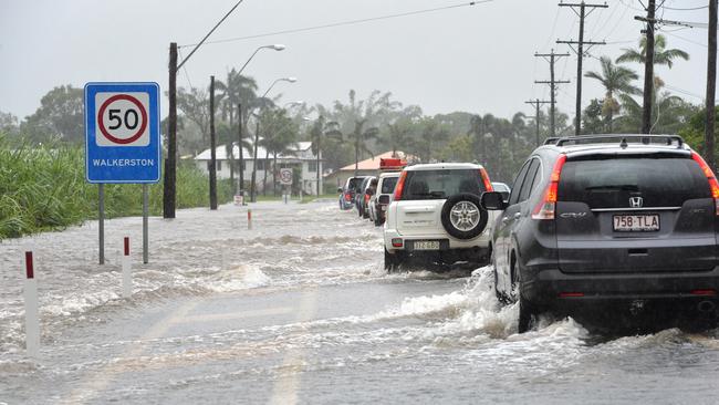
Mr Gray said BOM had been monitoring rain activity from Mackay up to Cairns with falls of up to 125mm at Proserpine and Cannonvale on Saturday.
"As we get further on through the week, it will still be fairly wet," he said.
"We'll see quite a bit of rainfall.
"Over localised areas, we might see 150mm, up to 200mm (of rain).
"There's a couple of wind warnings out now, these are strong marine wind warnings for the Cairns coast and the Townsville coast.
"For Monday, these will include the Cooktown Coast, Townsville Coast and Mackay coast.
"We may see some gale warnings issued tomorrow as well."
More stories:
10 new bus shelters to be built in Mackay
Fees slashed to make 'basic' Mackay campsites good value
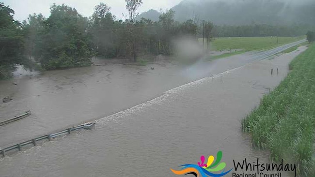
Whitsunday Regional Council's flood cameras show the road at Crofton Creek, Airlie Beach, was under water on Sunday morning.
See 'How to prepare for a cyclone' for more information on how to get your home ready.
Saturday's rainfall totals elsewhere:
Mount Jukes, 27mm
Hamilton Island Airport, 69.6mm
Proserpine Airport, 26.6.mm
Mirani Weir, 4mm
Gargett, 16mm
Bowen Airport, 10mm
Subscriber benefits:
How to activate your free Courier-Mail subscription

Man killed in ride-on lawnmower rollover tragedy
A 56-year-old man has died in a horror tragedy after the lawnmower he was riding rolled and landed on top of him. The death has sparked a workplace health and safety investigation.
Mine worker dies on site
The resource industry’s health and safety watchdog has given control of a Central Queensland mine site back to the owners following a sudden early-morning death.