
Flash flooding, thunderstorms hit southeast Queensland
After a chaotic day of flash flooding, road closures and rescues, BOM experts say Brisbane residents can expect a “calmer” night after a day of wild weather. However a severe thunderstorm warning remains in place further north.
QLD News
Don't miss out on the headlines from QLD News. Followed categories will be added to My News.
THE southeast is in for a “calmer night” of weather, following a day of widespread storms that caused chaotic flash flooding and train lines to close.
Bureau of Meteorology forecaster Matt Bass said showers and thunderstorms will continue for a couple of hours in areas north of Brisbane, particularly in areas around the Sunshine Coast, and in the inland Burnett region.
‘Weather gods are smiling’: Mary River flowing again
Flash flooding and transportation nightmares across southeast
At 10.05pm, BOM issued a severe thunderstorm warning for parts of the Sunshine Coast and Moreton Bay with severe thunderstorms were detected on the weather radar near Palmwoods, Mapleton and Maleny.
The storms are moving towards the southeast and are forecast to affect Landsborough, Crohamhurst and Nambour by 10:35pm and the area southwest of Caloundra, Mount Beerwah and Beerwah by 11:05pm.
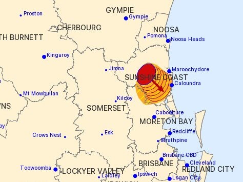
A storm warning issued earlier this evening for parts of Kingaroy and Nanango has since been cancelled.
“Those showers and storms are likely to continue over the next couple of hours but probably are on an easing trend,” Mr Bass said.
“Most of the activity with have died off around about midnight so it should be a calmer night overall than last night, but still a risk of the odd shower or thunderstorm about.
“We’ll see showers and storms reforming across the southeast, Darling Downs, Wide Bay and Burnett during tomorrow so we’ll get those showers and storms popping up again tomorrow, with heavy falls still possible. It’s pretty similar for Tuesday too … A bit of a groundhog day as the upper trough that’s driving all of this isn’t moving too far.”
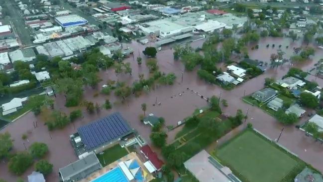
Today’s deluge brought widespread flash flooding across southeast Queensland, with Mt Lindesay Hwy closed and the Ipswich train line between Wacol and Gailes closed in both directions.
Trains have resumed, although a number of roads still closed across the southeast and south west regions.
Heavy rain this morning brought widespread flash flooding across southeast Queensland, with Mt Lindesay Hwy closed at Browns Plains and police saying the Logan Mwy could be closed at short notice.
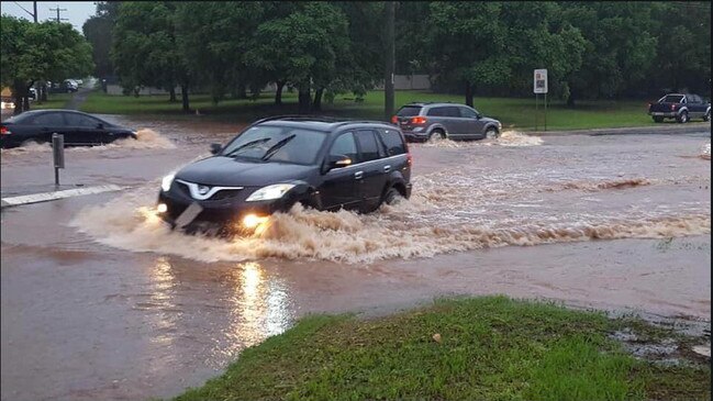
Several roads across Brisbane’s southside and in the city’s west have been closed or partially closed due to flash flooding.
Traffic wasn't the only problem caused by this morning's flash flooding! Some cars were caught in a tricky spot on Didswith Street, East Brisbane. Please keep an eye on weather warnings and move vehicles to higher ground if necessary. #BneStorm pic.twitter.com/lgjsfksJRa
— RACQ (@RACQOfficial) February 6, 2020
BRISBANE ROADS AFFECTED BY FLASH FLOODING
– Mt Lindesay Hwy, Browns Plains
– Vulture St, South Brisbane
– Beaudesert Rd, Rocklea
– Granard Rd, Archerfield
– Gap Creek Rd, Kenmore Hills
– Illaweena St, Drewvale
– Main Ave, Coorparoo
– Compton Rd, Slacks Creek
– Fairfield Rd, Yeerongpilly
– Paradise Rd, Larapinta
– Lancing Street, Pullenvale
– Grandview Road, Pullenvale
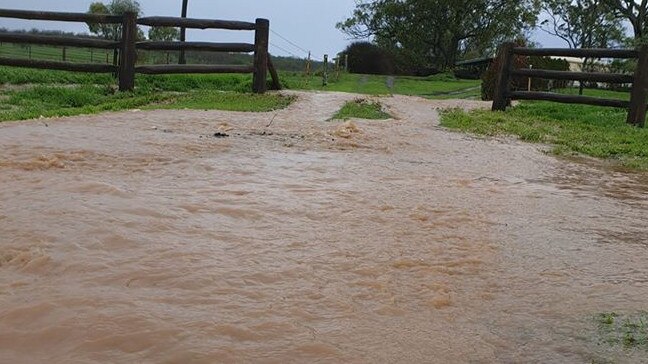
An emergency alert was issued for Dalby residents, with Myall Creek reaching moderate flood levels, peaking at 3.15m at 6.00am. It is expected to remain above 3m throughout Sunday morning as floodwaters continue to arrive.
Residents have been advised to monitor the situation, notify neighbours and take action to protect lives and property, if necessary.
The New England and Cunningham highways have been cut by flash flooding near Mount Marshall and Glengallan, north of Warwick.
DALBY REGION ROAD CLOSURES
– Bunya Hwy, Dalby. Approximately 9km north of Dalby. All lanes affected.
– Drayton St – Myall Creek Bridge, both lanes affected.
– Tara/Wieambilla – Chinchilla Tara Rd, Day St, Sara St
– Warkon – Warkon Rd, Litani Rd
– Noorindoo – River Rd, Yuleba Surat Rd
– Wallumbilla North – Kangaroo Creek Rd
– Dargal Road – Bungeworgorai Lane
– Bungil – Roma Southern Rd
– Ballaroo – Naldera Rd, Maranoa Rd
– Wycombe – Roma Southern Rd
GOLD COAST ROAD CLOSURES
– Maudsland – Birds Rd (Coomera River Causeway flooding)
– Clagiraba – Clagiraba Rd (Coomera River Causeway flooding)
WARWICK REGION ROAD CLOSURES
– Warwick – Killarney/Morgan Park – Warwick Killarney Rd
– Allora – New England Hwy
The Toowoomba area bore the brunt of the chaos overnight, with at least nine separate rescues last night, including two 19-year-olds who were taken to hospital as a precaution after being saved from a car in Greenmount.
Campervan tourists pulled into landslide after torrential rain in Byron Bay
Queensland weather: Rain records smashed, much more on the way
Falls of up to 145mm were recorded in the region, cutting multiple roads. Many areas around Toowoomba received more than 100mm, including Oakey.
The Gold Coast was also hammered, with more than 180mm falling at Coolangatta, while further north Amberley was drenched by more than 75mm.
The weather bureau earlier said the rain had been having little impact on dam levels and arrived too late to save many farmers from a disastrous summer.
Heavy falls are set to continue today and tomorrow, with Gold Coast and Sunshine Coast beaches facing a potential pounding from a looming Coral Sea cyclone.
Parts of the southeast have had more rain in the past three weeks than all of last year, but the deluge has barely registered when it comes to topping up dams drained by the drought.
While smaller dams are spilling over, Wivenhoe – the region’s biggest – was at 42.6 per cent capacity after a rise of just 0.1 per cent.
Despite falls of more than 200mm in some catchments, combined dam levels in the southeast’s water grid had risen less than 1 per cent yesterday to 56.6 per cent. That level is expected to change as inflows arrive.
Forecast rainfall of more than 100mm across the region in the coming days was expected to add just 1 per cent to combined dam levels – two weeks’ supply – and Seqwater is urging people to continue to conserve water.
Brisbane and Northern NSW was also lashed with heavy downpours last night, while the Scenic Rim, Southern Downs, Toowoomba and Lockyer Valley had storm warnings in place.
Roads were closed across the Southern Downs, with flash flooding closing two streets in central Toowoomba. Flooding also closed parts of the Cunningham Highway between Warwick and Inglewood.
Darling Downs farmer Kim Bremner said his 480ha property had received more rainfall in the past three weeks than all of last year.
“Total rainfall from January to December last year was 130mm and we’ve had 170mm in the last three weeks,” he said. “It’s been a godsend, because it was really bad before Christmas. Hardly any summer crops were planted across the Downs.”
But Mr Bremner said the rain had arrived too late to save the summer crops.
Emma Arkinstall, 7, was dancing in the rain after her Christmas wish was granted.
Like many of her neighbours in Running Creek, near Rathdowney, she could not wipe the smile from her face when the rain began.
Her family’s farm has received 200mm this year alone. It only had 240mm of rain last year. Emma’s father, Matthew Arkinstall, said the green countryside had slowly returned.
“By the end of February we should have made last year’s total,” he said.
The heaviest falls have been on the Gold and Sunshine coasts, with Tin Can Bay recording almost 400mm in the past week. Coolangatta had more than 170mm and Brisbane almost 190mm.
CURRENT RAIN TOTALS
Darling Downs
Athol Westbrook Creek – 145mm
Wellcamp Airport – 129mm
Oakey – 126mm
Goomburra – 123mm
Warwick – 104mm
Toowoomba – 66mm
Southeast
Coolangatta – 180mm
North Stradbroke Island – 87mm
Brisbane – 21mm
Ipswich – 76mm
Tallebudgera – 52mm

What Alfred really did to Queensland’s economy
Ex Tropical Cyclone Alfred dampened Queensland’s economic performance - but not in the way you might think.

Qld’s trade outlook more bullish than expected amid US wrangling
Queensland is punching above its weight, ranking third in CommSec’s latest quarterly economic performance report.