
Qld storm Chaser Justin Noonan records rare tornado that hit Kaimkillenbun during Western Downs supercell storm
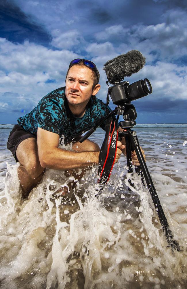
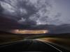
While most people’s first reaction would be to flee from a tornado, Queensland storm chaser Justin Noonan runs towards them camera in hand. This is how he found himself in the right place at the right time to capture one that formed in South West Queensland.
Dalby
Don't miss out on the headlines from Dalby. Followed categories will be added to My News.
The Western Downs region was battered with heavy winds on Thursday afternoon with gusts upwards of 60km/h leading to a rare phenomena, and one dedicated storm chaser was in the right place at the right time.
Severe thunderstorms lashed South West Queensland on Thursday afternoon as supercell storms delivered strong winds and heavy rain, while leaving hundreds around Dalby without power.
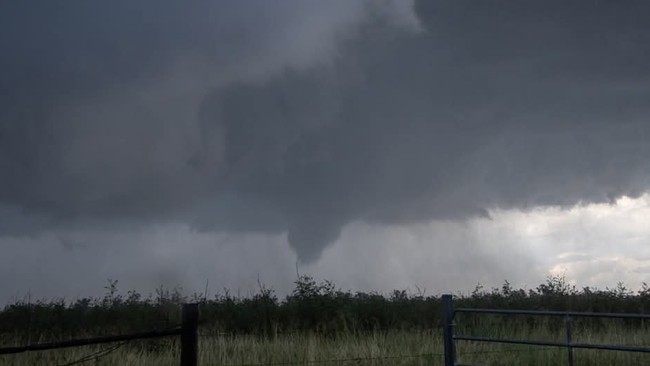
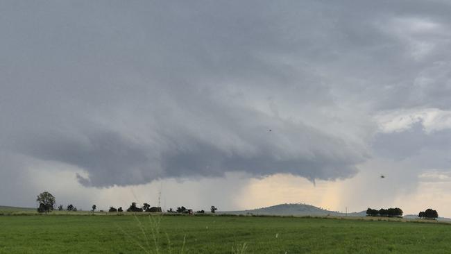
Forming in the supercell 5km out of Kaimkillenbun, a tornado was also seen by residents, and storm chaser Justin Noonan captured stunning footage as the funnel formed and touched the ground.
Mr Noonan, who has been storm chasing for 20 years including stints in America, said it was rare and exciting to capture a tornado in Australia.
“It was pretty amazing, it was a day we were expecting to see some higher end supercells, but to see a tornado the way we did was unusual,” he said.
“Tornados in Australia are much rarer than in the US, we typically get 50 to 100 a year but to see one close to populated centres is rarer.”
The Queensland storm chaser said he has been fascinated with storms since he was a kid.
“I grew up in South East Queensland and had a big farm in 1996 when Tropical Cyclone Justin hit,” he said.
“I was a teenager and I was always harassing the bureau for data, I got my driver’s licence in 2001, chased my first storm and never looked back.”
Mr Noonan said the recent hot weather had created the perfect conditions for a tornado to form.
“We had a dry line set up to the east which is warm and unstable while to the west it was dry, when the winds converge they can't go through the earth’s surface so they rise and that’s how the storm develops,” he said.
“It really tapped into necessary the ingredients and went 0 to 100.
“This it the fourth Australian tornado I’ve seen, we do get a lot of storms across the eastern seaboard but the tornado is less common because we don’t have the lower level wind shear.”
Mr Noonan said he had been tracking the storm for several for several days and had rushed to the Western Downs to capture it.
“A couple of days out from the storm we are looking at the models, looking for ingredients which produce those storms,” he said.
“The morning of we are looking at the radars and satellites, then you choose your target area, for us it was around Dalby and you wait and wait until you get a sunburn. When it initiates you take off and position yourself in the best place to document.
“Once we have the data and footage we try to refer it back to the bureau, our report goes into the warnings and helps prepare people downstream from the storm.
“We also get some great videos and photos.”
Mr Noonan said it was exciting to be up close and personal with the rare tornado.
“From our vantage point we saw it touch the ground for five to 10 seconds but the funnel lasted four to five minutes so it was probably on the ground for 60-90 seconds,” he said.
“It was such a beautiful scene and I’m an adrenaline junky so it is a great phenomena.
“There is a lot of excitement and joy and it was a little bit of disbelief, to score an Australian tornado.
“You also have this sense of panic because you know it won't last long and you don’t want to miss it.”
Bureau of Meteorology meteorologist Pieter Claassen said there would be just one more day for the heatwave condition for southeast Queensland.
“Today is expected to be a very warm day across the southeast in line with the temperature that we saw on Wednesday,” he said.
“We’re seeing temperatures five to seven degrees above average across Queensland.
“There’s a very side chance or a slight risk of a thunderstorm in the afternoon, which may provide some localised cooling, but any thunderstorms are likely to be very isolated this afternoon.
“We are likely to see a cooler change move through late tonight across the southeast.”
Mr Noonan’s photography can be found here.
More Coverage
Originally published as Qld storm Chaser Justin Noonan records rare tornado that hit Kaimkillenbun during Western Downs supercell storm
How a supermarket trip landed a Chinchilla woman in court
A Chinchilla woman who pointed and laughed at her ex made the outlandish claim she didn’t know it was him because he was wearing a bucket hat.

Drunken man uses pram to smash partner’s windows
A 20-year-old Kingsthorpe man has been told to ‘do better’ after he drunkenly smashed up his partner’s house windows in front of their young child. DETAILS.